|
THE GRAND JUNCTION CANAL
A HIGHWAY
LAID WITH
WATER.
STATE OWNERSHIP
“I need not say more than that every inquiry into the problem
since and including the valuable report of Mr. Neville Chamberlain
in 1921 has been unanimous in saying that there was no alternative
to compulsory amalgamation if the canals were not to go further into
decay. We cannot escape that conclusion. While we cannot
encourage the hope of any large expansion of canal traffic, we
believe that with the economies to be secured by amalgamation and
with the aid of new capital to be raised on the basis of public
credit, something can be done to restore their position.”
Lord Pakenham ― House of Lords debate on the
Transport Bill, 20th May 1947
. . . . but despite the best efforts of the Docks and Inland
Waterways Executive, and then of British Waterways, British canals as
commercial carriers had had their day and the next two decades were
to see considerable uncertainty about their future.
NATIONALISATION
Following the Labour Party’s election victory in 1945, Clement
Atlee’s government set about implementing a mammoth programme of
nationalisation. Utility companies and major industries were
taken into state ownership and by 1951 some 20% of the British
economy was in the public sector.
Under the Transport Act, 1947, railways, long-distance road hauliers
and some inland waterways were nationalised [1]
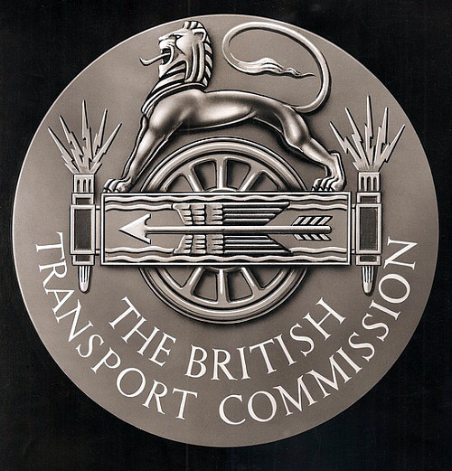
and placed under the control of the newly formed British Transport
Commission (BTC) whose remit was to provide “an
efficient, adequate, economical and properly integrated system of
public inland transport and port facilities within Great Britain for
passengers and goods”, but excluding air transport. The
different modes of transport were to co-ordinate their activities to
supplement each other rather than compete, but little of the
intended integration ever materialised.
The BTC was steered by the Ministry of Transport on matters of
general transport policy. It exercised control over its vast
empire through a number of ‘Executives’ set up to manage specific
sections of the transport industry. As from 1st January 1948,
the Grand Union Canal Company’s assets were taken over by the ‘The
Docks and Inland Waterways Executive’. [2] The
former Grand Union Canal (excluding the section north of Leicester),
the Birmingham Canal Navigations (to the east of Birmingham), the
Oxford and Coventry Canals, and the Lee and Stort Navigations were
grouped together to form the Executive’s South-eastern Division.
Thus, the thrust of the 1906 Royal Commission’s recommendation on
state control was fulfilled, although not quite as the Commission might have
imagined: [3]
“I think that hon. Members opposite must congratulate themselves
on their Transport Act, 1947, which while all its provisions were
not, perhaps, entirely acceptable to this side of the House, did in
one respect implement the recommendation of every Royal Commission.
It got our inland waterways under uniform ownership. That was
the first real ray of light shed on our canal system for nearly a
hundred years.”
David James M.P. ― House of Commons Debate on Inland
Waterways, 4th December 1959.
During the following decade, the Executive (and later the BTC itself
[4]) invested in British canals, [5]
but the large backlog of wartime neglect coupled with the high cost
of remedial work and the rapid growth of road haulage [6]
made significant modernisation uneconomic. Canal carrying
continued its decline, relying increasingly on subsidy to make good
its losses. Between 1954 and 1962, the total tonnage conveyed
by inland waterways decreased by 8% (that conveyed by the British
Waterways fleet fell by 18% during the same period) while the annual
deficit [7] increased from £153,000 to £1,068,000.
[8]
――――♦――――
A DECADE OF REVIEWS AND REPORTS
During the 1950s, two important reviews of our Inland Waterways took
place. Although neither had immediate impact, taken together
their recommendations were to shape future policy.
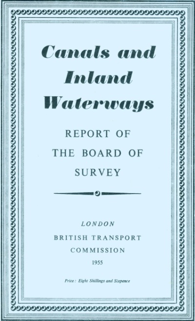
In 1955, a ‘Board of Survey’ under the chairmanship of Lord Rusholme
recommended that canals and inland waterways should be categorised
under one of three headings, their future being determined
accordingly:
Group 1, comprising commercially viable waterways (mainly
river navigations), should be retained and improved. This
group comprised the River Trent, the River Severn, the River Lee
Navigation, the River Weaver, the Aire and Calder Navigation and the
section of the Grand Union main line south of Berkhamsted.
Group 2, comprised most of the narrow canals and some wide
canals, such as the Leeds and Liverpool Canal and the Grand Union
main line north of Berkhamsted, which still carried some commercial
traffic. Attempts should be made to increase commercial use,
but if that failed, the waterway should be relegated to group 3.
Group 3: comprising the remainder, should be considered for
disposal to organisations other than the BTC, or closed.
Following consideration of the Rusholme Report, in 1956 the BTC
embarked on a £5.5 million improvement programme, some of the
investment being spent on the Grand Union Canal’s southern section
where work included:
“. . . . dredging, and the reconstruction of Thames and Brentford
Locks and certain lock sills, culverts and bridges, will enable
Lee-type barges of 135 tons to reach wharves and warehouses at
Brentford Depot, and craft carrying at least 90 tons to navigate as
far as Berkhamsted . . . . Bank protection and new dredging plant
are all part of these programmes.”
Report of the Committee of Enquiry into Inland
Waterways, H.M.S.O., July 1958
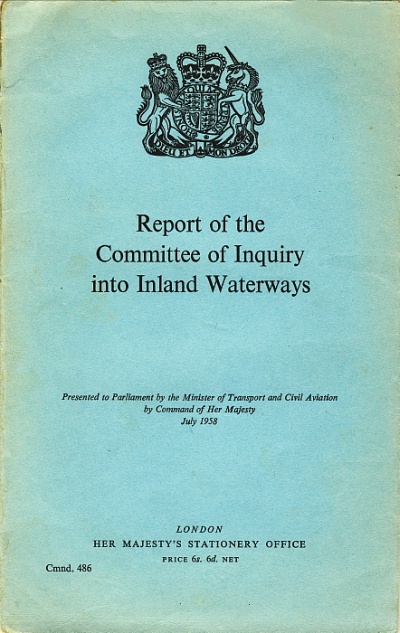
Rusholme was followed in 1956 by a wider ranging survey under the
chairmanship of Leslie Bowes, Managing Director of the Pacific Steam
Navigation Company. The Bowes Committee reported in 1958; by
then only 1,400 miles of the 2,170 miles of waterways controlled by
the BTC remained in commercial use. Bowes recommended much the
same categorisation of waterways as Rusholme ― the Grand Union Canal
still being divided at Berkhamsted ― but made three further
important recommendations. First, that an annual licence fee
should replace the chaotic toll structure that had existed since the
canals were built and which was recognised to be an anachronism:
“If any of us tried to operate a lorry on a road which may not be
in existence in ten years’ time and which is, in any case, subject
to varying charges between points A and B, which could not be
determined in advance, we should have some idea of the difficulty
facing operators of canals, and a uniform annual charge based on £1
per ton per annum would seem to be a very effective answer.”
David James M.P. ― House of Commons Debate on Inland
Waterways, 4th December 1959
Second, waterways, which Rusholme classed as Group 2, should have an
assured a life of 25 years. The Bowes Committee were
“convinced that confidence in the future existence of the latter
waterways is an indispensable condition of a revival of traffic upon
them”. And third, that more emphasis be placed on deriving
revenue from other sources, such as water sales, angling and
pleasure boating ― although on the latter, the Committee concluded
that “the amount of additional revenue which can be foreseen from
pleasure boating is small in relation to total revenue”, for
even as late as 1958 Bowes still held the view that had prevailed
within the Grand Union’s boardroom some 30 years earlier, that with
sufficient investment in the infrastructure, canal carrying could be
revived. With regard to completing the Grand Union Canal
Company’s abandoned improvement of the Birmingham main line, Bowes
had this to say:
“A tentative estimate of the cost of making this canal navigable
by vessels of 14ft beam carrying about 90 tons which could load or
unload alongside ships in the Port of London, [9]
through to Birmingham without transhipment, is £4.2 million,
including works on locks, bridges and culverts, bank protection,
dredging and additional water supplies, but does not include the
cost of acquiring any additional land. The estimated cost does
not appear a high one in relation to the addition to the nation’s
transport facilities which could be expected to result from
efficient water transport between Birmingham and the London docks,
apart from any increase in intermediate traffic which might arise.”
Report of the Committee of Enquiry into Inland
Waterways, H.M.S.O., July 1958
It is difficult to understand the basis for this conclusion, for in
the years 1955 and 1956, the southern (commercially viable) section
of the Grand Union Canal turned in a small operating surplus (£7,359
and £4,475 respectively) while the northern section made a
significant loss (£64,592 and £61,301 respectively). On the
eve of the UK’s motorway network, [10] the
position was hardly likely to improve, even assuming the Treasury
was persuaded to put up the required £4.2 million.
Finally, Bowes was divided equally on whether inland waterways
should remain the responsibility of the BTC or whether they should
be placed in the hands of a separate canals conservancy. But
on this point any continuing debate was settled by the Transport Act
1962, [11] which abolished the monolithic BTC, its
inland waterway assets being transferred to the newly formed British
Waterways Board (the Board), the gist of whose brief was to:
“. . . . manage the undertaking with ‘due regard to efficiency,
economy and safety of operation’ and, secondly, to review the whole
problem of waterways which are no longer self-supporting and to
formulate proposals with the object of putting these waterways to
the best use.”
The Facts About the Waterways, the British
Waterways Board, December 1965
The Board commenced work with yet a further review of its estate.
In their interim report, published in 1964, the Board found the
Grand Union Canal to be a heavy loss-maker, but despite this they
took a relatively optimistic view of the waterway’s future
including, for the first time, its use as part of a “pleasure
network”:
“The Board are also disturbed by the losses on the main line of
the Grand Union Canal. These amount to about a quarter of a
million pounds a year. Toll revenue has been falling for a
number of years and there is no immediate prospect in sight for
arresting this decline. Revenue from water sales is
appreciable but total income falls far short of meeting the heavy
cost of maintenance. However, given the crucial position it
occupies in the pleasure network and its potential importance in the
water supply field, and given that some existing commercial traffic,
and possibly some further potential traffic, remains on this
waterway, we think that there will probably be general endorsement
of the view that the Grand Union main line should be one of the
waterways given a reasonable security of tenure ― which is so
necessary to make the best use of those canals which are to be
retained. We shall continue to investigate all possible
methods of reducing expenditure to accord with the present usage
pattern of the Grand Union Canal.”
The Future of the Waterways: Interim Report of the
Board, 1964
Dr. Beeching ― by then applying his axe to the railway network with
vigour ― might well have reached a different conclusion.
The Board published their final report in the following year. [12]
In it they identified nine waterways (mostly ‘navigations’, such as
the Aire and Calder) that they considered to be commercially viable,
plus a further three that were in substantial commercial use despite
being unprofitable. Among the latter was the southern section
of the Grand Union Canal, [13] which remained in
regular commercial use by short-haul traffic. The Board
recognised that this section offered “a great potential in
avoiding road congestion in and around the Metropolis”. It
was in good condition, the BTC having invested in extensive dredging
and bank protection, and it fulfilled an important land drainage
role in that area of West London. With regard to the remainder
of the main line from Slough Junction to Birmingham, the Board had
this to say:
“The Grand Union Canal main line to Birmingham is financially
perhaps the Board’s most intractable single problem. For both
historical and geographical reasons it has always been considered as
a major trunk route in the canal system, linking London and the
Thames to the Birmingham canal network. Physically it is in
good condition. Its commercial traffic, however, has steadily
declined over the years and is now negligible, and there is a very
heavy financial deficit.”
The Facts About the Waterways,
the British Waterways Board, December 1965
The Board divided the Canal into two sections, above and below Slough Junction,
for which they costed three options; to continue operations (the ‘do nothing’
option), to convert the canal to a water channel (i.e. merely
to convey water) and elimination. Despite its heavy
maintenance costs, the Board concluded that the southern section
should have an assured a life of 25 years with its annual deficit,
estimated initially at £70,000 p.a., being met by subsidy while
attempts were made to increase commercial traffic. But the
costed options for the northern section of the main line
demonstrated that conversion to a water channel was the most
economic (economy of operation being a key requirement in the
Board’s brief):
(a) The deficit incurred in maintaining the Grand Union main line
(above Slough Junction) to navigational standards was well over
£150,000 a year.
(b) The existing deficit would be reduced to about £87,000 a year if
the canal were to be converted to a water channel.
(c) Elimination would scarcely be realistic except on the middle
length, where however it would cost more than conversion to a water
channel.
The Facts About the Waterways,
the British Waterways Board, December 1965
Elimination was considered unrealistic due to cost and the
engineering difficulties involved. It could at any rate only
be considered for the central section, [14] for
south of Tring Summit the canal supplied water to the viable
waterway below Slough Junction, while parts of this section
consisted of canalised rivers that performed an important land
drainage function. Similarly, the Braunston Summit reservoirs
supplied water to the North Oxford and the Warwick and Napton canals
(there being appreciable water sales at Leamington). The
problems attendant on elimination were by then well known, and while
the following claim made during an earlier parliamentary debate was
not universally true, it did apply in some cases:
“We have an inescapable form of expenditure in that it costs more
to fill in a canal than to dredge it and make it available to use.
In particular, we know that the cost of filling in the Avon Canal
[the Stratford-upon-Avon Canal] was to be £120,000, while the
National Trust hopes to redevelop it for about £55,000.”
David James M.P. ― House of Commons Debate on Inland
Waterways, 4th December 1959
There was also a heavy deficit ― £44,000 for 1964 ― on the operation
of the Leicester Section, with negligible commercial traffic and
pleasure traffic that was “not extensive”. Here the
‘water channel’ option appeared the most viable, for although
elimination would deliver a somewhat greater saving in the long
term, the Foxton summit and the Saddington reservoirs provided an
indispensible water supply to the Grand Union Canal at Norton
Junction. The Aylesbury Arm was also subject to the Board’s
scrutiny. It too was in deficit, ― £6,404 for 1964 ― but here
the Arm’s need for water from the main line made elimination an
attractive option (£3,500 p.a. reducing to £2,200 p.a.) and also
slightly cheaper than conversion to a water channel (£2,300 p.a.).
And so ‘The Facts About the Waterways’ was passed to ministers and
their civil service advisors to await policy decisions.
――――♦――――
THE END OF NARROW BOAT CARRYING
While the Board pondered the commercial viability of what remained of the
UK’s inland waterways, they made a prompt decision on the future of
their narrow boat carrying operation on the Grand Union Canal.
By 1962 the South-eastern Division’s operational narrow boat fleet
had fallen to 45 pairs, with manning continuing to be a problem as
crews retired or left the waterways for shore-based employment.
The position was exacerbated by the severe winter of 1962-63 [15]
which, when taken with the continual losses incurred by their narrow
boat fleet, was probably the last straw. Unlike the Bowes
Committee, who a few years earlier had reached the extraordinary
conclusion that “. . . the operation of British Waterways’ fleet
is generally welcomed, particularly on the narrow waterways, and we
recommend that it should continue”, the Board recognised that
the decline in narrow boat carrying was both accelerating and
irreversible and they withdrew from this business during 1964.
Narrow boat carrying on the Grand Union Canal did not cease
immediately. Willow Wren Canal Transport Services took over
the remaining BW contracts and leased 25 pairs of their boats.
Their boatmen carried the operational expenses of the boats and paid
a percentage of their earnings to Willow Wren, but the firm found
that the business did not pay and ceased trading in 1970. Blue
Line Canal Carriers took over the Samuel Barlow coal carrying
business in 1962, and continued carrying coal from Baddesley
Colliery near Atherstone on the Oxford Canal to Kearley & Tonge’s
jam factory at Southall until the factory closed in 1970. The
last regular cargo was barrels of lime pulp, shipped from Brentford to Rose’s factory at Boxmoor until
it closed in 1981.
――――♦――――
THE 1968 TRANSPORT ACT
The Labour Party was returned to office in 1964 and in December of the following year Barbara Castle
was appointed Minister
for Transport. In this role she was to be responsible for
introducing the mammoth Bill that eventually became the 1968
Transport Act, now remembered mostly for its introduction of seat
belts, tachographs into commercial vehicles and passenger transport
executives. At the time the Treasury was planning further
growth in road transport ― which
then accounted for 90% of passenger miles and 60% of freight ton
miles ― and with this end in mind they intended a Beeching-style elimination of the canal
network, with some canals being transformed into roads (transforming
canals into roads was not, at the time, a new idea ―
House of Commons Debate, 27th April
1954).
Although Mrs. Castle presided over Beeching closures amounting to
some 2,000 miles of railways, she staved off the assault on canals
by emphasising their essential role in land drainage and the high
cost of constructing alternative drainage measures (or letting
arable land revert to bog) if they were to be eliminated. The
outcome was that the Treasury plans were shelved and an
“extensive and exhaustive” consultation process commenced, its
principal aim being to establish the size of the pleasure cruising
network to be retained. The views of quangos, trade
associations, local clubs and “many hundreds of individuals”
were taken from which one key point to emerge was the need to
“retain waterways forming part of through or ring routes”.
At the close of consultation, the Ministry summed up the situation
in the following prophetic words:
“Pleasure cruising on inland waterways and rivers is no longer a
pastime within reach of only the well to do. The Government
welcomes this and believes that in the next few years more and more
people will want to use the waterways for spare time relaxation and
quiet holidays. Therefore, the Government intend, at the
outset, to retain for pleasure cruising substantially the existing
network available for this purpose. The British Waterways
Board will be given the new and positive duty of maintaining these
waterways to a standard of navigability suitable for powered
pleasure craft. It is thus the Government’s intention that for
the first time, this recreational purpose of the nationalised
waterways should be recognised by public Act of Parliament.”
British Waterways: Recreation and Amenity
(Cmnd. 3401) – Ministry of Transport, 1967
The report also recognised the important role of volunteers in
canal restoration:
“In recent years voluntary societies have put forward a number of
schemes for restoring lengths of disused canal to navigation.
Many of these schemes are highly attractive because they would
reopen waterways running through lovely countryside. On the
other hand the capital cost of such schemes can be very high and
each restoration, when carried out, brings in its train a new and
continuing liability for maintenance. Despite this the
Government is keen to encourage volunteer effort to develop the
amenity network of waterways.”
British Waterways: Recreation and Amenity
(Cmnd. 3401) – Ministry of Transport, 1967
And so the category of cruising waterways came to be recognised in
law and enshrined in the Transport Act, 1968. Although Mrs. Castle
moved office before the Bill completed its passage through
Parliament, the resulting Act did provide a measure of safeguard for
the remaining canal network. It classified the nationalised
waterways into three distinct categories:
-
Commercial ― waterways that could still support commercial
traffic; these were mainly located in the North East of England;
-
Cruising ― waterways that had a potential for leisure use, such
as cruising, fishing and recreational use;
-
Remainder ― waterways for which no potential commercial or
leisure use could be seen.
By
this time the Grand Union Canal had ceased to have any commercial
significance and had found its place among the cruising canals,
from:
“. . . . its junctions with the Birmingham and Fazeley Canal at
Digbeth and Salford to its junctions with the River Thames at
Brentford and at Regent’s Canal Dock, including the branches to
Northampton and Aylesbury and the Hertford Union Canal leading to
the River Lee at Old Ford . . . . [and] from Leicester to
Norton Junction including the branch to Market Harborough.”
British Waterways: Recreation and Amenity
(Cmnd. 3401) – Ministry of Transport, 1967
――――♦――――
THE AFTERMATH
Despite the 1968 Act recognising their amenity value, inland
waterways continued to attract little development funding, with
canal restoration relying greatly on the help of canal enthusiasts
and societies. Volunteer-led canal restoration began with the
Stratford-upon-Avon canal in 1960 (re-opened in 1964) to be followed
by the Kennet & Avon, Stourbridge, Ashton, Peak Forest, Caldon,
Monmouthshire, Brecon & Abergavenny canals among others.
Leisure boating continued to grow, and by the early 1980s the number
of craft using the waterways for leisure purposes exceeded 20,000.
Entrepreneurs began to see the profit potential in canal-side
locations for property development, the construction of marinas to
service the needs of the growing leisure-boating community, boat
hire and the operation of trip boats. And on the Grand Union
Canal, when the Blisworth Tunnel fell in need of major repair in
1980, the £4 millions necessary to finance the four-year project was
found.
By the late 1990s the canal network was flourishing. Revenues
generated for canal maintenance reached £100,000,000 for the first
time in 1998, large grants from the Heritage Lottery Fund allowed
the canal network to expand again by restoring former canals, and
additional funding was announced for British Waterways in 1999 by
the then Deputy Prime Minister, John Prescott. By the early
2000s, boating numbers had overtaken the previous industrial
revolution high, and the canal network was officially classed as
‘safe’ following the completion of all outstanding safety works.
There are now about 2,200 miles of navigable canals and rivers
throughout the United Kingdom.
The role of British
Waterways has now been taken over by the Canal & River Trust (Glandwr
Cymru in Wales), thus bringing to an end over 60 years of state
control. The Trust will be funded through a combination of
income from Government, boat licences, third party grants and
commercial activities. The main change will be through the
establishment of a guaranteed, long-term contract with Government
(giving greater certainty over funding); a ‘charity lock’ on British
Waterways’ property endowment; and growing income from tax relief
and charitable sources (e.g. donations, legacies etc).
It is also expected that the inland waterways currently managed by
the Environment Agency will transfer to the Trust in 2015.
As for the Grand Union Canal, it continues to carry canal boats
across the Chilterns while volunteers from the Wendover Arm Trust
are hard at work returning our town’s northern boundary to
full operational use . . . . |