|
“WENDOVER, a market town and borough of
England, in the county of Buckingham. It is but an
inconsiderable place, consisting chiefly of mean brick
houses, and possesses no trade or manufacture of any
consequence, except lace making, from which the
inhabitants derive their chief support. A branch of the
Grand Junction Canal, called the Navigable Feeder, has
been brought into the town, which may be of some
importance to its trade.”
The Edinburgh Gazetteer, or, Geographical Dictionary
(1822)
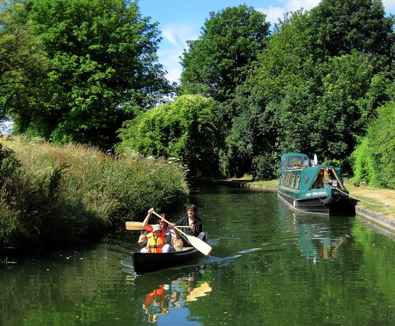
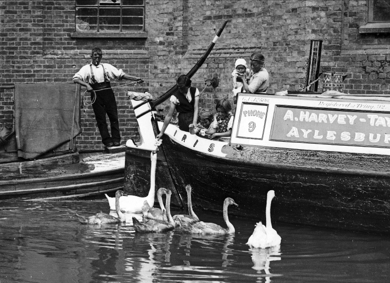
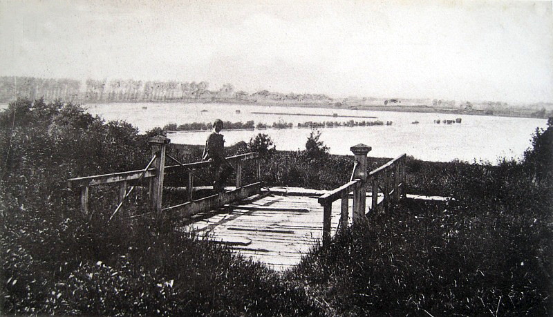
Navigating the Wendover Arm at Little Tring.
――――♦――――
――――♦――――
WATER FOR THE SUMMIT
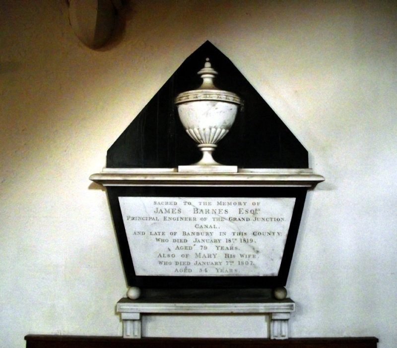
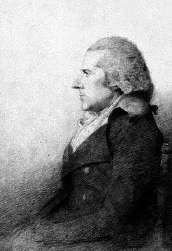
IN addition to
the many construction problems facing James Barnes and William
Jessop [1], the
Grand Junction Canal’s (GJC)
civil engineers, was that
of locating sufficient water to flood the Tring summit (the Canal’s
other summit at Braunston posed less of a problem).
During the canal carrying era, water shortages, when they occurred, adversely affected the flow of trade and the canal company’s
revenue. But keeping a canal flooded was often no easy task,
particularly at high points along its route where obtaining
sufficient water could prove challenging. Here, the canal
engineer had to resort to various strategies: seeking a route that
avoided high ground so far as possible (which might involve excavating tunnels,
as at Braunston and Blisworth); diverting into the canal
what rivers, streams and drainage channels existed in the locality
(which often gave rise to conflict with local water millers); and
using steam-powered pumps to raise water from low-level sources,
such as reservoirs, bore holes and lower sections of the canal
itself. Maintaining a sufficient supply at the GJC’s
summit at Tring has proved a particular problem, for despite all the usual
strategies having been employed, reports of low water levels
adversely affecting
trade during prolonged periods of dry weather arose throughout the
Canal’s commercial life and continue to the present day. [2]
The Chiltern Hills, a 47 mile-long chalk escarpment, lie
across the path that the Marquis of Buckingham commissioned Barnes
to survey in 1792. Confronted with this unavoidable barrier, Barnes
routed the canal through the ‘Tring Gap’, a lowering in the ridge of
the Chilterns that has been used as a crossing point since ancient
times. [3]
Taking account of the likely traffic levels across the summit and
the water requirement for lockage, it must have appeared that the
springs that rose in the Tring Gap together with local drainage were
unlikely to be sufficient and it
was therefore necessary to import supplies from further afield.
As shall be seen, this task was to present its own challenge over
many years.
The Chiltern Hills are composed of chalk, some 90 million years old.
Because chalk is porous, it absorbs and stores rainwater, in effect
forming a massive underground reservoir (aquifer), which is
maintained by a stratum of impervious clay (gault) beneath it.
Natural springs appear wherever the base layers of chalk come close
to the surface. At Wendover, some 6½-miles to the west of the
Canal‘s summit pound, such a spring
emerges at Wellhead, near to St. Mary’s Church, where water from a
point at which the Coombe and Boddington hills meet wells up to the
surface. This abundant supply formed the Wendover Stream,
which flowed northwards through the valley driving numerous water
mills on its way to join the River Thame. In the absence of a sufficient supply closer to hand, Barnes
planned to divert the Wendover Stream into a channel, which was to follow
the contour eastwards along the northern face of the Chilterns
intercepting other spring-fed streams en route [4]
to join the main line at Bulbourne [thus ― unlike its near
neighbour, the
Aylesbury Arm ― the Wendover Arm is an
example of a ‘contour canal’, one that by following the contour
avoids the need for locks and (for the most part) other engineering
work, such as cuttings and embankments].
|
“A meeting of the commissioners who are named in the
act, for deciding all differences or disputes between
the Company and individuals or bodies of men, began on
Monday morning last, and continued its sittings until
Wednesday, at Aylesbury; when the long existing disputes
between the Company and the Millers on the Thames River
were fully gone into. We are happy to hear, that
the Millers at the conclusion, unanimously agreed to
withdraw all claims for satisfaction, for the water of
which, they have been hitherto deprived; so satisfied
were they, that the measures adopted within this two or
three years past, on the Tring and Wendover summit level
of the Canal, will amply supply it in future, without
sensible injury to the mill-streams.” |
|
Morning Post,
30th August 1805 |
Having received authority under the 1793 GJC Act to construct
whatever feeders were necessary to obtain canal water, the Grand
Junction Canal Company (GJCC) entered into purchase
negotiations with local landowners and the inevitable water-millers
to construct what at the time was to be no more than a feeder
ditch. To placate the millers, whose livelihoods would
inevitably be damaged by the diversion of the Wendover Stream, the GJCC bought the water mills at Weston Turville and Wendover, and the
water rights to the mill at Halton, [5]
only then to find that other millers further downstream at Aylesbury
were also affected. To address this, a new reservoir was built
at Weston Turville. Eventually, the GJCC bought the Aylesbury
mills, thus avoiding the need to supply them with ‘compensation
water’.
Weston Turville reservoir lies about a mile to the north of
Wendover town centre and adjacent to the Arm. It accumulates
water mainly from two streams below the level of the canal and from
any overflow from the canal itself. Built in 1797-8, it is the
earliest and most westerly of the five reservoirs that lie along the
foot of the Chiltern escarpment. Although not intended to
supply the canal, in 1814, following several years of poor water
flow, a temporary Newcomen-type pumping engine was installed to
raise water from the reservoir as and when required. No clear
information remains as to the capacity of this pumping station, but
it is known that its outflow pipe into the canal was four inches in
diameter. Weston Turville pumping station remained in use
until about 1838, and was eventually scrapped in April 1841.
Since then water has occasionally been taken for the canal during
periods of drought, but today the reservoir is used for recreation.
Further to the east lie the four Tring Reservoirs.
They comprise Wilstone (1802, heightened in 1811 and 1827, and
extended in 1836 and 1839), Marsworth (1806), Tringford (1816) and
Startops End (1817). Of these, Wilstone is by far the
largest.
The opening of the GJC in 1800 [6]
resulted in more traffic than had been anticipated, added to which
the Aylesbury Arm (opened c. 1815) imposed a significant
drain on the main line. Consequently, the demand for water
at the summit increased. To address this, the Tring reservoirs
were built in stages to provide further supplies, which
they accumulated from local streams and any surplus from the canal
itself.
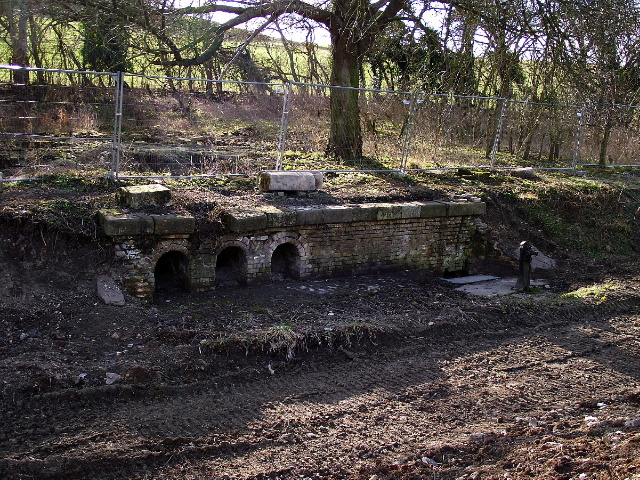
The visible remains of Whitehouses pumping station.
Originally, the reservoirs were worked by three pumping stations
located above them on the Wendover Arm; Whitehouses pumping station
(between Drayton Beauchamp and Little Tring, capacity believed to
have been 30 locks per day) worked Wilstone
Reservoir, a pumping station near Bulbourne Junction worked
Marsworth Reservoir, and Tringford pumping station (sited by Thomas
Telford) worked the Startops End and Tringford reservoirs.
Each pumping station lifted water into the Arm to flow into the main
line at Bulbourne Junction. In his Encyclopædia of Civil
Engineering (1847), Edward Cresy states that:
“. . . the principal engine at Tring is estimated as a 70
horse-power; its consumption of coals is about 1½ cwt. per hour,
with a 40 feet lift; this engine works at a pressure of 24 pounds,
makes ten strokes per minute, and pumps up sufficient for eighty
locks in 24 hours.”
Writing some years ago, Tring local
historian Bob Grace stated that:
“. . . the great reservoirs at Tring were not constructed in their
present form in the first instance. First of all they were
just ‘heads’ - the Ashwell Head at Wilstone and the Bulbourne Head
at Marsworth, which were dammed up and small pumping engines put in
to pump direct into the Wendover navigable feeder, one pump being
halfway between the main arm and New Mill and the other pump being
at the White House, above Wilstone reservoir. These were the
first engines of the neighbourhood and the men who came to work them
were, of course, engineers, the first to come into this part of the
world.
The engines were vacuum engines, which meant that they worked on
very little steam pressure (about 5 p.s.i., I think), from very
simple boilers. The engine was activated by the weight of the
pump bucket drawing up the piston and the piston cylinder being
filled with steam from this boiler, then a jet of water was squirted
in condensing the steam. The vacuum then formed drew up the
bucket and brought up the water to the canal level. These two
engines were extremely inefficient, even by the standards of those
days, and they were soon replaced by engines put in at the Tringford
station. These were two great beam engines.”
When Tringford pumping station was built in 1817, it was equipped
with a Boulton and Watt beam engine of 80 locks per day capacity, so
it is probably this engine that Cresy refers to. However, in
the period 1836-38, the Tring reservoirs were interconnected by a
system of tunnels to enable all pumping to be centred on Tringford.
A second (second-hand) steam pump (capacity unknown) — named the
‘York’ — was then installed to handle
the increased load, and this engine remained in operation until 1911
when it was replaced by
diesel-electric plant.
Following the centralisation of pumping on Tringford, the pumping
stations at Weston Turville and Whitehouses were demolished ―
Marsworth pumping station had been dismantled in 1819, as this
reservoir could then be pumped from Tringford through the new
Startopsend reservoir. Nothing remains of
the pumping stations at Weston Turville and Marsworth, but some brick
foundations and culverts on
the canal bank mark the site of Whitehouses. [7]
In 1927, Tringford pumping station became wholly
electrically-driven. The original Bolton and Watt engine was
then removed – it was offered for preservation, but in the absence
of any takers it was sold for scrap – and the building
greatly
altered (and much for the worse!) including the removal of its prominent chimney.
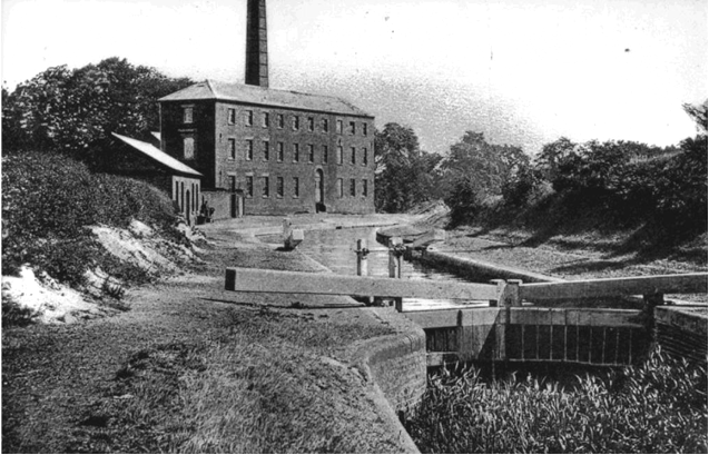
Above: Tringford pumping station and stop lock, c. 1910.
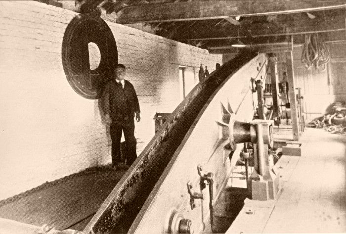
Below: the beam of one of the station's steam pumping engines.
.jpg)
|
A
Mirrlees 2-cylinder slow-speed diesel engine
of the type employed at Tringford Pumping
Station.
The York engine was removed in 1911 and
replaced by a diesel electric pump to work
the original deep well. A second diesel
electric pump was installed in a newly
constructed high-level well with a new
incoming heading from Tringford Reservoir
only. These pumps designated No.1 and No.2
were powered by two diesel generating sets,
one a 50hp single cylinder, and one a 100hp
twin cylinder (pictured above), supplied by
Mirrlees, Bickerton and Day. These
generators remained in use until the 1960s
when the pump motors were replaced with A.C.
motors powered by mains supply. |
In 1870, the GJCC came into legal conflict with the Tring
Local Board of Health over contamination of Tringford Reservoir and
the spread of disease:
“Part of the drainage of this town [Tring] is carried away
by a sewer which empties itself into the canal-reservoir to the
north. Before this sewer was made the reservoir received only
spring-water, a matter of some importance, as some neighbouring
villages drew their water from the stream that flows from the
reservoir. After the turning in of the sewer, in summer, when
the water in the reservoir was low, it stank abominably; and worse,
diphtheria, typhoid fever, and other such diseases, were frequent in
the villages.”
The water supply of Buckinghamshire and of
Hertfordshire by W. Whitaker (1921)
The GJCC sued for damages. They complained of the pollution
and of the additional expense incurred in pumping water up from
Tringford reservoir that would otherwise have flowed directly into
the Wendover Arm along Tring Brook. However, the Master of the
Rolls dismissed the case (with costs) on the grounds that the Board
of Health were acting in the lawful exercise of their powers.
The following year, the GJCC mounted an appeal. The Master of
the Rolls had apparently misdirected himself, for according to The
Times the GJCC were granted an injunction against the board of
Health (with costs), the Lord Chancellor ruling that “the right of
enjoyment of surface water in a flowing stream must not be
interfered with” ― public health issues did not appear to enter into
the argument! Standards of public health have of course
improved out of all measure since 1870, and today the summit pound
obtains a useful supply of cleaned water from Tring sewage works,
which is pumped into the Wendover Arm just to the east of Gamnel
Bridge.
And where does the Wendover water released from the Tring
Summit finish up? That which flows southwards along the canal
eventually reaches the Thames at Brentford. That which flows
down the sixteen locks of the Aylesbury Arm eventually enters the
River Thame, discharging into the Thames in the vicinity of
Dorchester (Oxfordshire). Water that flows northward along the
canal discharges over weirs into the Rivers Ouzel and Nene until at
Cosgrove, where the canal commences its ascent towards Braunston
Summit, it discharges into the Great Ouse, this flow eventually
reaching the Wash.
――――♦――――
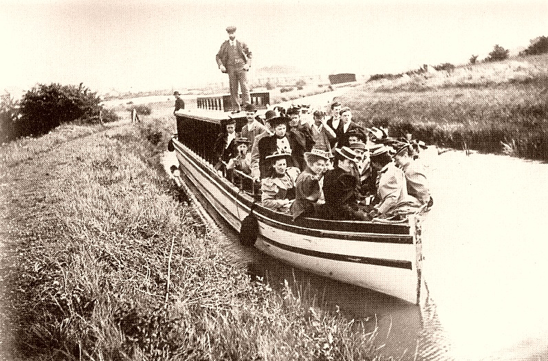
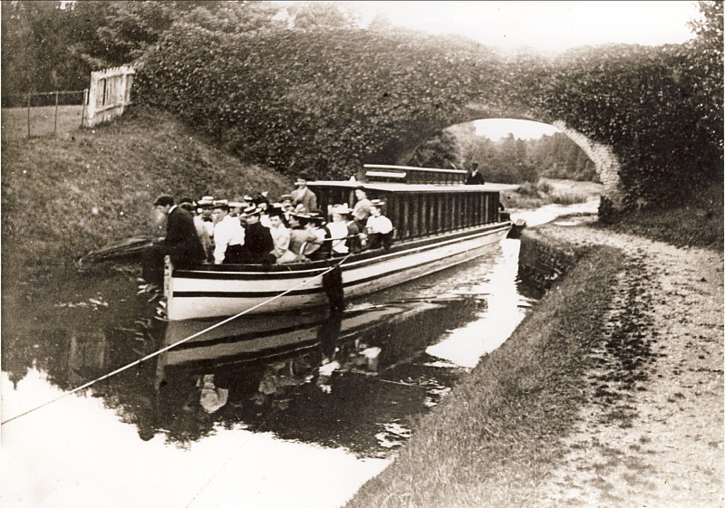
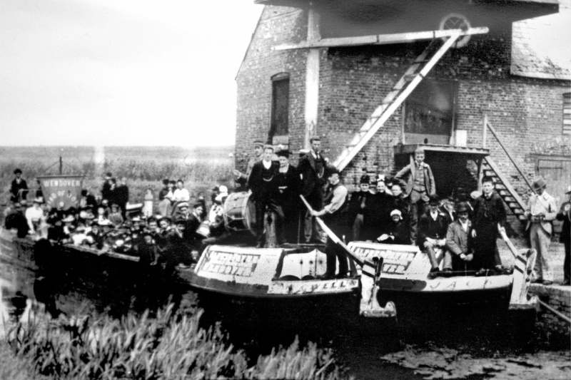
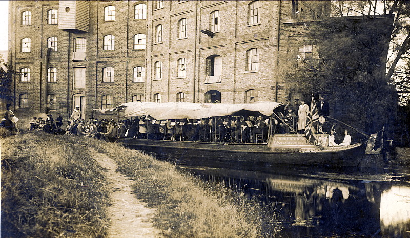
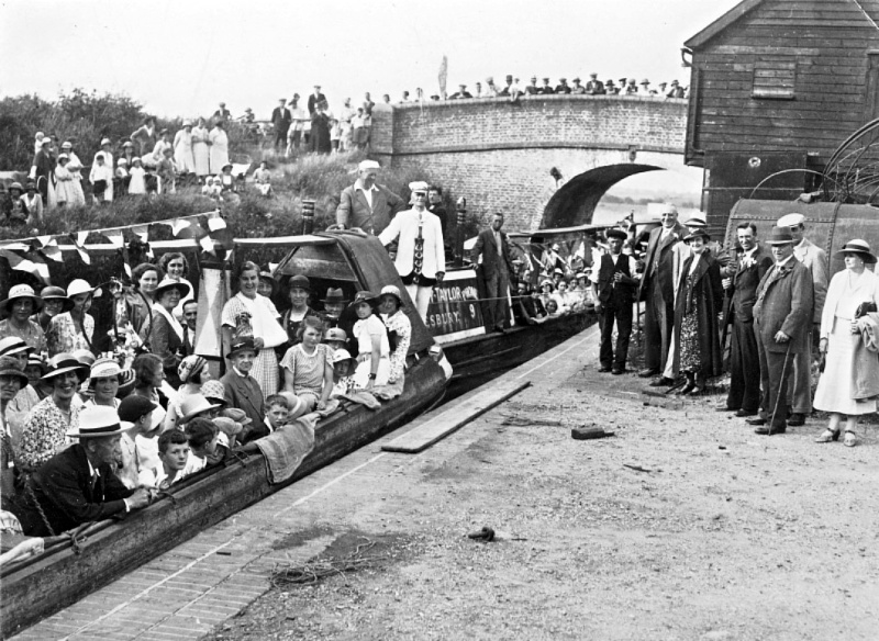
An outing to Wendover by members
of the Akeman Street (Tring) Baptist Church in 1897.
Top: approaching Little Tring. Bottom: at Hare Lane bridge
(No. 8).
THE COMMERCIAL CANAL
IN addition
to its role as a feeder for the Tring Summit, the Wendover Arm
enjoyed a century of commercial life; indeed, on its eastern
section, shipments of grain to Tring Flour Mill continued
until the end of WWII, when road transport took over, while the
adjacent Tring Dockyard survived until 1952.
Plan of the Feeder ditch as originally conceived.
The route that was to be followed at New Mill differs considerably
from that eventually constructed.
Plan
(jpeg, 3.3MB - back arrow to return)
Although originally planned as a feeder channel,
at some stage during the land purchase negotiations the GJCC decided
― believed to have been in response to local lobbying ― to make the
feeder navigable and thus revenue-earning. Enlarging the feeder
involved little extra cost, but its change of use did require a
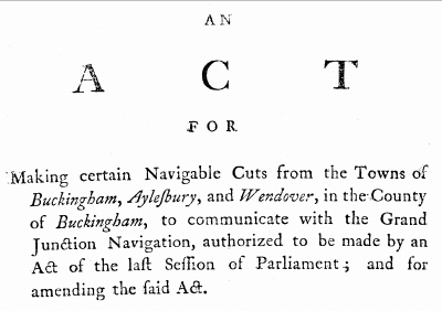
further Act of Parliament. Thus, the following statutory
notice appeared in the newspapers published along the line of the
GJC, giving notice of the Company’s intention to apply to Parliament
for an Act which, among other things, would authorise them:
“. . . . to make navigable, the cut or feeder now making, and
intended to be made, by the company of Proprietors of the Grand
Junction Canal, from the town of WENDOVER, in the said county of
Buckinghamshire, to the summit-level of the Grand Junction Canal, at
Bulbourne, in the parish of Tring, which is to pass in, to, or
through the several parishes of Wendover, Halton, Weston-Turville,
Aston-Clinton, Buckland, and Drayton-Beauchamp, in the said county
of Buckingham; and the parish of Tring; till it joins the said
summit-level at Bulbourne aforesaid. Dated this 5th day of
September, 1793.”
E. O. Gray, Aston Chaplin, Clerks to
the Company
|
 |
|
Title of
the 2nd GJC Act; 34 Geo, III. C. 24 |
Reference to the “feeder now making” illustrates that
construction of the Arm commenced at an early date, well before the
main line reached Tring Summit (probably) early in 1799. The new
Act (34 Geo, III. C. 24) was obtained on 24th March, 1794, together
with statutory authority to build branches to Buckingham, Aylesbury and
Saint Albans (the latter not proceeded with).
Although the exact date of the Wendover Arm’s completion is
unknown, it was probably during 1794, for in his progress report of
May of that year, Jessop states that “About seven-eights of the
Wendover Canal is cut”, and in a GJCC circular of November,
1797, reference is made to “The Wendover collateral line, now
finished for the sake of the water”. However, as the main
line, which opened to Berkhamsted late in 1798, probably reached
Tring Summit early in 1799, trade on the Arm would not have
commenced until then. The first clear intimation that the Arm
was fully in business appears in Jackson’s Oxford Journal,
which reported that the section of the GJC from Tring to Fenny
Stratford was officially opened on 28th May, 1800.
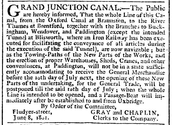
|
Morning Post ― announcement of the opening of the GJC, 18th
June, 1801. From the south, the GJC probably reached
Stoke Bruerne late in 1800, where a break in the Canal (bridged by a
horse-drawn railway) existed until the Blisworth Tunnel
was completed in 1805. |
For most of its working life the western section of the Arm
avoided railway competition, and until the opening of the Aylesbury
Arm (c. 1815), also carried traffic destined for Aylesbury:
“The Oxford canal, constructed under the superintendence of
Brindley, was finished in 1790, and was opened with great
rejoicings; it materially affected Aylesbury; coals and heavy goods
were brought by it to within 25 miles of the town, the intervening
distance being accomplished by road-waggons. The main supply
of coals for Aylesbury was then obtained from Oxford. In the
year 1799 the Wendover Branch of the Grand Junction Canal was
completed, which was a great advantage to this district. The
traffic in coals and heavy goods was transferred from Oxford to
Wendover Wharf, within five miles of Aylesbury.”
Buckinghamshire: A History of Aylesbury,
Robert Gibbs (1885)
‘Wendover Band of Hope’ outing at Wendover
Wharf, 1889.
The narrow boat owner is Alfred Payne of Wendover.
Wendover Wharf lies a short distance to the north of the town
centre, [8] the
original access being from the end of Clay Lane across grazing land
belonging to Manor Farm. In 1796, Wharf Road was built (at
that time ending at Wendover Wharf) to give proper access to the Arm
from Aylesbury Road. Wharf Cottage, which still stands, was
the wharfinger’s
residence and warehouses (long gone) were built at the wharf
opposite the tow path. It is known that grain was landed there
for milling at the great octagonal brick-built tower mill (now
converted into a beautiful private dwelling) that stands on the opposite side of Aylesbury
Road, perhaps including that referred to in the following report:
“Philip Goodenough was indicted for stealing four bushels of
wheat, the property of Joseph Hoare. The prisoner was the
master of a barge . . . . in which a quantity of wheat was sent from
London to Wendover, consigned to Mr. Hoare . . . when this wheat
arrived at Wendover, four bushels of it were found missing.
The only evidence against the prisoner was that of a lad, named
Merchant, who had acted as his servant in the barge. He said, that
after the barge had passed Chelsea bridge, the prisoner took a spare
sack and filled it, by taking a small quantity from each of the
other sacks that were full; when the barge arrived at a place called
Harwood, on the Grand Junction Canal, a man came up and took this
sack so filled from the prisoner.”
The Times, 15th January,
1801.
Shrinkage of the sort described must have been common ― it
certainly was with coal. Hay and straw were also brought to
the wharf from the surrounding fields and shipped to London, and
manure was received in return. Slater’s Directory for
1852 lists several coal merchants at the wharf; indeed, a
correspondent writing in the Bucks Herald in 1906 had this to
say about the Wharf’s coal
trade: “Fifty or 60 years ago [c.
1850] waggons from places as far off as Lewknor and Aston Rowant
were to be seen en route through Bledlow all the way to Wendover
Wharf, for coal brought there by canal”. The wharfinger at
that time was John Bell, who offered water conveyance “To London
and forward, goods to most parts of the kingdom”.
|
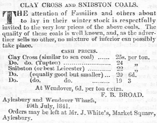 |
|
Coal from Wendover Wharf – Bucks Herald, July
1841. |
There were a number of other wharfs on the Arm (App.
I.), the main ones being at Gamnel (also known as Tring
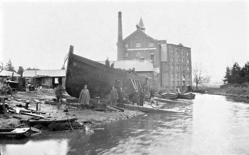
Wharf) and at Buckland to the south of Aston Clinton. A trade
directory listing of 1854 suggests that Buckland wharf was managed
by the landlord of the adjacent New Inn, whose other listed
activities were “coal
merchant and collector of taxes”.
A pair of Alfred Payne (Wendover) narrow boats at Buckland.
The New Inn is in the background, Buckland Gas Works was opposite
the narrow boats.
The site of Gamnel Wharf had previously been occupied by a
water mill that had been bought for its supply of water and
dismantled by the GJCC. The first reference to the Wharf itself
occurs in the GJCC Minutes. On 14th October 1800, a wharf at Tring
(presumably Gamnel Wharf) was auctioned for three years from 29th
September. It was taken by James Tate, a coal merchant, for £15 per
annum (the Company Minutes for this period also record that the
fishing rights for most of the Wendover Arm were let in June 1800 to
Acton Chaplain, the GJCC’s Clerk, for twenty one years, at £2 10s a
mile). A deed of transfer records that on 5th July, 1810, the GJCC sold to William Grover, for £400, “all that wharf land and buildings thereon
containing one acre and three roods more or less situate next Gamnel
Bridge in the Parish of Tring.” Grover must have seen a
business opportunity to continue the milling previously done on the
site, but by wind power; the tower
mill that he erected at Gamnel became the seed from which eventually
grew Heygates Mill, the large flour-milling complex that occupies the
site today.
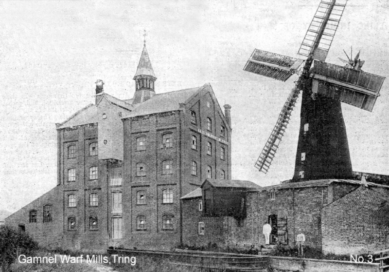
Gamnel Wharf windmill ( built c.
1812, pulled down in 1911) and steam mill (built 1875) ― note the
lightening boat in the foreground.
Mr. & Mrs. Ward, daughter Phoebe and
her family from Startops End,
discharging Manitoba
wheat at Tring Flour Mills c. 1930s.
The 50th birthday
celebration for William Mead (owner of Tring Flour Mills -
background) in 1918, during which
he entertained wounded soldiers and airmen from RAF Halton Camp
hospital, near Wendover.
The narrow boat Victoria is registered to Frederick Mead of
Paddington.
Grover was also active as a canal carrier, his listing in Pigot’s
trade directory for 1839 advertising “To London
and all places on the line of the Grand Junction Canal, and goods
forwarded to all other parts of the Kingdom, by Grover and Son, from
Gamnel wharf, and Thomas Landon, from Cow Roast wharf, daily”.
Nothing then is known of Gamnel Wharf until the business changed
hands in January 1843, when the following notice appeared in the
Bucks Advertiser:
“William Grover, in the town of Tring in the County of
Hertfordshire, having on the 28th day of January last disposed of
the business of wharfinger, coal and coke merchant and mealman, and
dealer in hay, straw, ashes, and other things, lately carried on by
him in partnership with Thomas Grover, at Tring Wharf, and at
Paddington in the County of Middlesex, under the firm of ‘WILLIAM
GROVER & SON’ to his sons-in-law, William Mead and Richard Bailey.
Messrs. Mead and Bailey beg to announce that they will continue to
carry on the same business, upon the said premises, in partnership
under the name of ‘MEAD & BAILEY’. All debts due to and owing from
the said William Grover, will be received and paid by Mead &
Bailey.”
Bucks Advertiser,
January 1843.
The notice gives a good indication of the nature of the business
carried out, not just at Gamnel Wharf, but at Wendover and at many
wharfs in rural locations at that time.
|
 |
|
Transhipping grain from lighter to narrow boat
at Brentford. |
Mead and Bailey continued to offer a diverse range of
services, later advertising themselves as millers, coal merchants,
wharfingers, and water carriers. [9]
A few years later the partners advertised London horse manure
(mountains of it were generated in the horse-powered Metropolis of
that age), which they shipped by canal from their wharfs at
Paddington. Paddington Basin was also the scene of another
William Mead & Co. activity, that of transporting by canal London’s
rubbish for disposal in worked-out gravel and sand pits, and at
nearby brick-yards (which recycled the cinders) ― a magazine article (App.
II.) written in 1879 describes both the early use of
electric light for illuminating the refuse wharfs and the unsavoury
nature of Mead’s rubbish disposal business.
Shipments of imported grain were also delivered to Mead’s flour mill
at Tring by canal from the London docks via Brentford, where the
grain was transhipped from lighters to narrow boats for its
journey up the GJC. Grain shipments to the mill continued until the end of World War II, when road haulage took
over.
In addition to the commercial wharfs on the Arm, there were
two small canal-side gas works, which supplied town gas to the
Rothschild mansions at Aston Clinton and at Halton. Wendover Gas,
Coke & Light Company was also located near the Wendover canal wharf. The
close proximity of these plants to the Arm suggests that they
received supplies of coal by narrow boat and might also have
exported the by-products of the town gas manufacturing process (coke, coal tar, sulphur and
ammonia) by this means.
The last business to use the Arm was Bushell Brothers, a firm
that over the years built and repaired a wide range of craft
including canal barges of various types, pleasure boats, maintenance
flats, tugs and a pair of fire floats for John Dickinson’s paper
mills. The firm ceased trading when the brothers retired in
1952, although by then the boat trade had diminished and the firm
were building bodies for a range of commercial motor vehicles.
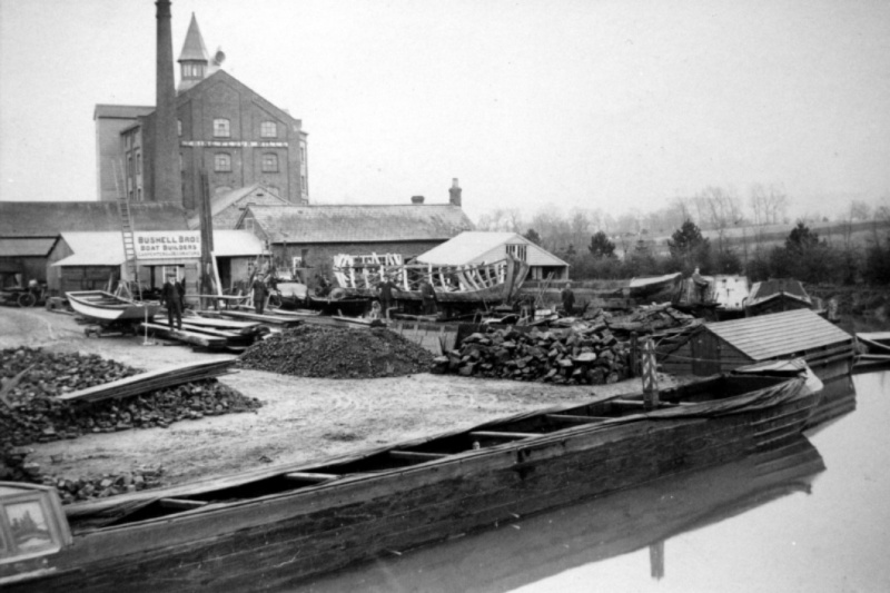
Bushell Bros. boatyard (Tring Dockyard) ― Tring Flour
Mill to the rear.
Reproduced by kind permission of Miss Catherine
Bushell.
Tug ‘Bess’ under construction at Tring Dockyard, 1921.
At 75ft x 14ft 6ins x 5ft 6ins draught, her size was such she could
only just pass along the Canal to London.
Reproduced by kind permission of Miss Catherine
Bushell.
――――♦――――
|
 |
 |
|
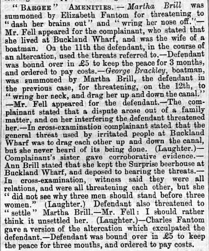
Canal-side trouble at
Buckland Wharf.
Bucks Herald, 27th September 1884. |
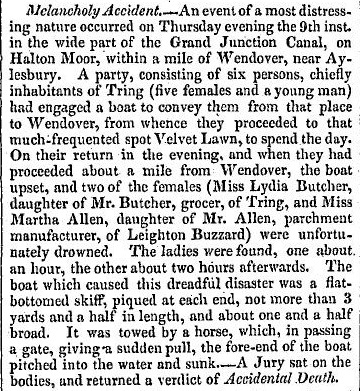
Melancholy
Accident at Halton Moor.
Jackson’s Oxford Journal, 18th September 1824 |
Sunday school outing about to depart from Gamnel
Wharf, 1931.
Reproduced by kind permission of Miss Catherine Bushell.
――――♦――――
LEAKAGE AND PARTIAL CLOSURE
CONSTRUCTION of
the Wendover Arm started soon after the 1793 Act had been obtained,
for in a report submitted in May 1794, Jessop informs the Board that
the Arm was almost complete, but not yet flooded. From the
outset it appears that he knew that the chalk terrain over which
part of the Arm was to pass would prove difficult and that leakage
might be a problem:
“About seven-eights of the Wendover Canal is cut, — the remainder
having corn on the ground, will rest till after harvest; in the mean
time what is done will be gradually tried with Water, for much of
the ground in this line is very leaky, and must be lined with Earth,
and be saturated with muddy Water: the rule that has been generally
observed — of avoiding plain cutting until necessity calls for it,
has a reasonable exception in this case, for by exposing it to the
changes of Weather, and particularly to Frost, the Chalk will
dissolve into a pulpy substance, and facilitate the operation of
Puddling.”
William Jessop, London, 27th May 1794.
The first reported leakage was in 1802, and in the following
year the Arm was closed for some months for remedial work.
This was carried out under the supervision of the canal engineer
Benjamin Bevan, who during the project procured more water for the
Arm at
Wendover (App. III.)
and submitted his proposal for what was to become Marsworth
Reservoir. When the civil engineer Thomas Telford inspected
the GJC in 1805, his report picked up on Jessop’s concern, expressed
a decade earlier, about leakage on the Arm:
“A great proportion of the Wendover Branch is cut through loose
chalk; and Mr. Bevan appears to have laboured with much activity and
zeal to render the whole watertight: in this he has partly
succeeded; but much perseverance is requisite to make this important
part of the canal perfectly secure; the lining with clay must be
continued, and the banks must, in several instance, be made stronger
and higher. As much depends upon the perfection of this summit
I cannot help strongly recommending that every attention be paid to
it.”
Report on the General State of the Grand Junction
Canal, Thomas Telford, May 1805.
Further problems with leakage occurred for the remainder of
the Arm’s working life, the costs of significant repairs being
announced periodically in newspaper reports of the Company’s Annual
General Meetings. In 1855, the Arm was closed due to leakage,
but on this occasion repair was effected using a new form of lining,
asphalt, in place of the traditional puddle clay. This was
applied to the section of the Canal between Little Tring and Aston
Clinton and although it stemmed the leakage to some extent, it
became damaged by a combination of earth movement, by canal boats
brushing against it and through the use of poles. (App.
IV.) By 1897, the leakage had reached such an
extent that the Arm was drawing water from the main line. This
led to the Canal being dammed at Little Tring, where much of the
stop lock (built c. 1901) remains.
A number of schemes were then considered for restoring
navigation or, as an alternative, reverting the Arm to its original
role as a feeder. With the arrival of the Metropolitan Railway
at Wendover in September, 1892, the commercial future of the Arm
must have looked bleak, added to which the numerous attempts to stop
leakage over the years had proved expensive and unsuccessful.
These factors probably influenced the GJCC’s decision to abandon the
Arm as a navigable waterway west of Little Tring. However, the
closure was contested in the High Court, where their Lordships,
sitting as the Railway and Canal Commission, ruled unanimously in
favour of the GJCC, the gist of their argument being that the
Company was under no legal obligation to maintain the Arm as a
navigable waterway, and at any rate the economics of so doing would
have been prohibitive (the legal costs of the case would probably
have paid for the Arm to be repaired!).
The report of the case (brought by Lord
Rothschild, Lady de Rothschild and Mr Alfred de Rothschild) in
The Times also provides some interesting information on the
level of traffic on the Arm during its final years of commercial
operation:
“The earning, which at one period yielded a good profit, had been
on the decline for some time before 1898. In 1883, the number
of tons carried was 12,800, but the tonnage fell to 4,800 tons in
1893, 2,600 in 1894, and to less than 2,000 in 1896-7; and the
decrease in the receipts from tolls was from £1,100 in 1883 to £423
in 1893, and to about £200 between 1893 and 1898. One reason
of the traffic falling off was in 1894 the Metropolitan Railway was
opened to Wendover [reported elsewhere as Sept., 1892], and
from that time the Wendover traffic in coals was transferred from
the canal to the railway. On the other hand it is estimated
that the sum, that would have been expended on the part of the canal
at present closed, before it could again be used as a navigable cut,
would not be less than £22,000. The ground on which the canal
is constructed is chalk, and the necessity of preventing the loss of
water from the porousness of the chalk accounts for a large part of
the £22,000.”
Rothschild and others vs. the GJCC, The Times,
9th May, 1904.
The Arm was finally abandoned as a navigable waterway west of
Little Tring in 1904, although for some years before (probably since
at least 1897) it had only been in intermittent use. However,
as late as 1906, an appeal (typical of those that were to arise
during the branch-line closures of the Beeching era) was made to the
newly-convened Royal Commission on Canals to bring pressure on the
GJCC to reopen the Arm to navigation:
“. . . . With capable handling, however, the Canal could be made
to hold water effectively, and at no unreasonable cost. The
following figures represent part of the traffic in the year 1897,
immediately before the canal was closed:
Manure ― 500 tons were sent to Wendover, and 120 tons to Buckland
Wharf;
Hay and straw ― 350 tons were sent from Wendover, and 150 tons from
Buckland Wharf.
This represents part of the traffic when the Canal was only half
full of water, and boats had a difficulty in getting along partially
laden . . . . In many ways those living in the parts of the counties
served by the two branches are injuriously affected. By
increased cost of carriage of goods, equal to 2s. per ton to the
nearest railway Station. By inability to obtain manure for
farmers at a reasonable cost. By wear and tear of roads
through having to cart goods and coal which ought to come by water.
By having to cart hay, straw and cereals to the Railway Stations,
which represents 2s. in the ton extra cost to the farmers, and a
reduced rental to the landowners, besides extra rates to the general
public to cover wear and tear on the roads . . . .”
Bucks Herald, 2nd
November, 1906.
It is interesting to note the Arm’s importance to its local farming
community. Reference to it being “half full of water”
refers to the use of stop planks to block off the Arm prior to
construction of the Little Tring stop lock (c. 1901).
It appears that, as early as 1891, boats navigating the Arm to the
west of Little Tring had first
to be lightened to reduce their draft on account of its shallow water:
“The Clerk [to the Council] had also received a letter
from Mr Thomas Mead, of the [Tring] Flour Mills, complaining
that boats bearing dung [were] lightening their loads (for
the purpose of entering the shallow water of the Wendover Arm) near
their mills, and he wished the practice, if the matter came under
the jurisdiction of the Board, to be stopped. ― Mr Clarke
corroborated the facts of the complaint. ― Mr Baines [the
Council’s surveyor]
said that he had been to the spot, and told the boatmen that the
practice must be stopped, and that they must lighten elsewhere.
They asked him to allow them to lighten in the middle of the night,
and he gave permission for this to be done.”
Bucks Herald, 4th July,
1891.
Following closure, the section between Wendover and Drayton
Beauchamp was relined, the water level lowered and the flow from
Wendover diverted into Wilstone Reservoir. This scheme was
later changed, the water being channelled from Drayton Beauchamp
direct to Tringford pumping station through a pipeline laid along
the canal bed.
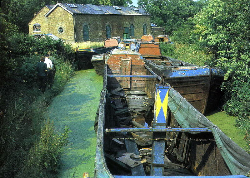
The much disfigured Tringford pumping station in the
late 1960s ― the Arm was then being used as a
dump for redundant narrow boats. Note the
condition of the tow path!
――――♦――――
RESTORATION
THE formidable
project of restoring the Wendover Arm to a navigable waterway beyond
Little Tring is being undertaken by members of the
Wendover Arm Trust. The Trust is a charitable body
formed in 1989 with the aim of restoring and promoting the Canal.
Its membership ranges from organisations with a specific interest
(such as the environment) to individuals who support the aims of
restoration in general. The Trust does not own the Canal; it
is owned by The Waterways Trust, who work closely with the Trust on
planning and undertaking its restoration, and are represented on the
Trust’s Board.
The engineering problems in restoring the Arm are believed to
be relatively straightforward, although the solutions are expected
to be expensive, with funding being a major obstacle. At the
time of writing, progress has been slow but significant.
Although some work had been completed earlier, the first
phase of the planned restoration was completed in March 2005.
It comprised the refurbishment of the stop lock at Little Tring; the
replacement of a road embankment across the canal bed at Little
Tring with a concrete road bridge, built to a traditional design and
faced with bricks to provide an authentic appearance; construction
of a winding basin at the terminus to allow boats to turn; and the
reinstatement of about ¼ mile of canal.
The second phase (expected completion in 2016) involves
restoring to navigation the section between Little Tring and an
isolated section of restored and re-watered canal to the west of
Drayton Beauchamp. The latter was constructed during the
building of the Aston Clinton Bypass in 2003, [10]
and involved a slight realignment of the Arm to provide navigable
headroom under the new bypass road bridge. Restoring the phase
2 section includes re-profiling the Canal to its original shape and
lining its sloping sides with concrete blocks on top of waterproof
Bentomat© lining [11]. Two new timber footbridges have already been erected
to enable the Canal to be crossed safely, and reinforced concrete
covers are being laid over the 100-year old buried pipeline to
prevent any subsidence should it collapse.
.JPG)
Relining the Wendover Arm - the upper part of the Bentomat liner, visible above the
protective blocks,
is about to be covered with turf.
At the canal bed, the liner is covered with 300mm of earth.
The main obstructions to be met during Phase 3 concern bridge
restrictions, these being the accommodation bridge at Buckland
Wharf, the ex-A41 road bridge and the lowered Halton Village Bridge.
The restoration of this section is technically feasible but
expensive.
――――♦――――
RECREATION, SPORT ― AND ALGAE
ANY large expanse
of water holds a certain fascination and from their early days the
Tring Reservoirs have been sites of recreation. Walking and
fishing provide much enjoyment, but at the head of the list must
come interest in wildlife. In recognition of this, the
reservoirs were designated a National Nature Reserve in 1955; in
1987, they were redesignated a Site of Special Scientific Interest
on account of their wealth of wildlife, particularly birdlife.
Because there are few natural lakes in Southern England, the
reservoirs provide an important haven for wintering water birds.
Weston Turville Reservoir is outside this group.
Although it continues to be owned by
The Waterways Trust, it is no longer
used to supply canal water. Managed by the
Berkshire,
Buckinghamshire and Oxfordshire Wildlife Trust, it too is
recognised as an important nature reserve while at the same time
providing an expanse of water for the enjoyment of members of the
Aylesbury Sailing Club, a nice mix of uses.
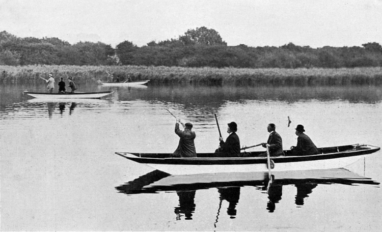
Lord Rothschild and
party duck shooting on one of the canal reservoirs, 1921.
Somewhat at odds with the above, for 130 years the sporting
rights to the reservoirs were retained by the landowners of the
Tring Park Estate, who arranged shooting parties for their
distinguished guests, which included on one notable occasion King
Edward VII. Until recent times the owners were entitled to
shoot on up to six days per year, their quarry being captive-bred
mallards reared on Marsworth reservoir and the smallest of the
reservoirs at Wilstone. A gamekeeper employed by the Estate
also managed the three reservoirs stocked with coarse fish and the
fourth with trout. From April 2008 British Waterways acquired
both the fishing and shooting rights, of which the latter has now
been discontinued.
As for swimming, during the first decades of the 20thC this
was a popular pastime and organised swimming galas were a regular
fixture. They were probably supervised and safe enough, but
the general practice was eventually banned due to several fatalities
caused by swimmers becoming entangled in water weed.
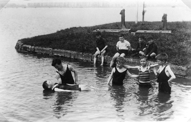
Swimming lessons, Wilstone Reservoir in the 1930s.
Prolonged dry spells, when the water levels fall drastically,
cause deep cracks in the reservoir beds and the growth of a toxic
phenomenon,
Blue-green Algae (Cyanobacteria).
These algae grow so rapidly they are difficult to control and can
produce toxins that are dangerous to humans as well as to animals
and marine life in general. Although susceptible to
herbicides, the problem can also be addressed with the use of barley
straw, which, in a complex chemical action, inhibits their spread.
Each of the reservoirs except Tringford, which is not affected, is
now strung with lines to which barley-straw mattresses are attached.
――――♦――――
APPENDIX I.
THE WHARVES.
TODAY it is
difficult to imagine that during the canal carrying era ― and
particularly before the onslaught of the railways (c. 1840s)
wiped out many of our canals (vide, for example, the fates of
the Kennet & Avon and the Thames & Severn canals) ― these waterways
were the trunk roads, even the motorways of their day.
Communities who were lucky enough to live near a canal route saw the
prices of coal, timber, building materials and even food fall
dramatically when the canal came to town. Those in rural areas
especially found a cheaper and quicker route to market for their
farm produce; there is much evidence, for example, that the Wendover
Arm was used to export hay and straw to the horse-powered
Metropolis, where it was converted into horse dung (manure) and
shipped back by canal for use as an agricultural fertiliser.
Although it was never particularly common, even humans travelled by
canal:
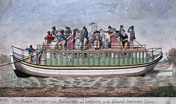
Passengers by canal on the Paddington branch of the GJC.
It is recorded that the poor left Aylesbury by barge on
the first stage of their journey in search of a better life in the
colonies or the New World, while newspaper reports of troop
movements by canal were quite common before the railway age:
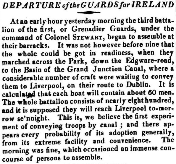
The Morning Post, 5th December, 1821
Indeed, the military even constructed a large barracks and
arsenal adjacent to the GJC at Weedon, and into which Barnes built a
short branch canal that entered the walled site through a portcullis.
Much cargo-handling on the Wendover Arm was probably carried out by
boatmen drawing up their craft adjacent to a farmer’s field, and
loading/discharging over planks between the boat and the bank. Where
an accommodation bridge was conveniently placed, it would probably
have been easier to moor under the bridge and transfer goods over
the parapet. But there is archaeological evidence of other
wharfs on the Arm in addition to those generally known about.
Research carried out by Barry Martin suggests there were wharfs of
some type at the following locations (moving upstream from Bulbourne
Junction):
-
on the right (non-towpath side), a few hundred yards above the
overspill weir, was the wharf edging for the Marsworth
Engine/Pump;
-
on the left bank just before Gamnel Bridge (bridge 2) there is
evidence of a wharf;
-
above Gamnel Bridge wharves associated with the various mills
and the boatyard;
-
further upstream, beyond the Tring Feeder, there was a small
wharf on the off-side, its edging being visible during
wintertime when the foliage recedes. Local
recollection is that it was a coal wharf;
-
the wharf edging associated with bringing coal supplies to the
Tringford pumping station remains in place;
-
the next definite wharf edging was for the Wilstone (Whitehouses)
pumping station;
-
just before Drayton Bridge (bridge 5) there was a brick wharf,
on the off-side, adjoining Bridge Farm. This was
certainly very evident when the first undergrowth clearance was
done in about 1977, but when BW restored this section of canal
the wharf was demolished;
-
next upstream was the wharf behind the New Inn, then beyond
bridge 6 (the old A41) there was the wharfage for the Buckland
Gas Works;
-
upstream of the Stable Lane (Wellonhead) Bridge (bridge 7) there
was a further slewing bridge which provided access from the Aston
Clinton House to the towpath side; although this is the site of
the “concreted narrows”, a brick-fronted wharf was visible a few
years ago;
-
if there were wharves at Halton, in the area of the now lowered
road bridge, they would have disappeared during the construction
of that bridge;
-
on the off-side, about 200 yards
further on, there is another small brick-fronted wharf which may
have been associated with the Dashwood estate. An old map (see
fig. ‘5’ at
Halton) of the
area shows that the Canal was widened locally and there was a
boathouse;
-
just before Perch Bridge, the Halton Gasworks would have had a
wharf on the off-side. Working boats were also known to
have moored upstream of Perch Bridge (out of site of Sir John’s
residence) and their crews visited the nearby Perch Inn, but
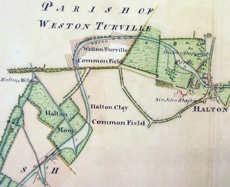
there probably wasn’t a wharf at this location.
-
the final wharf was probably that at Wendover, of which very
little remains today other than the name, Wharf Road, and the
wharfinger’s house.
――――♦――――
APPENDIX II.
FILTHY LUCRE
From GOOD WORDS
(Volume 20, 1879)
by
CHARLES CAMDEN.
I HAVE chosen my
title with reference to the nature of the materials from which the
gain of which I have to speak is extracted — very fertile “farms of
two acres,” some of our dingy dust yards prove — not with the
slightest to the character of the extractors. Through the courtesy
of Messrs. W. Mead and Co, I have been allowed to pay a visit or two
to a “contractor’s yard,” which claims to be the largest, at any
rate to do the largest business, in London. It is one of
several bordering the Paddington Basin, which from that circumstance
might be called, by a trade pun, a “slop” basin.
Most of the London dust-yards are at the water-side, for the
sake of the water carriage which the canal or river gives them for
their dust and cinders to the country brick makers.
In Messrs. Mead and Co.’s yard, the electric light is used
after dusk in winter, to enable the men to go on with the loading of
the barges. Wandering along the muddy North Wharf Road, with
its dozens of empty tumbrils resting with their shafts up in the
air, or crossing the canal and railway bridges in Bishop’s Road, you
catch sight of an aurora in the sky, and on entering the yard you
see a big meteor star, pulsing white and bluish white, suspended in
solitary brightness over the black heaps from which the weary
sifters have gone home to rest, weirdly lighting up the men plying
pick and shovel down by the canal, and making part of the sluggish
water seem to be phosphorescently afire. As far at the
influence of the light extends, the separate stones can be
distinguished on the gravel wharf, and within that circle the
lamp-posts and the buildings of the yard stand out clear as by
daylight, or rather clearer, since the mysterious brilliance seems
to purge them of their grime. But all gas-jets are turned into
mere faint bilious blotches and outside the magic circle the
darkness, both on land and water, is intensified into ebon gloom.
And now for the daylight aspect of the yard, or rather yards.
An apology for untidiness on a contractor’s premises has a somewhat
droll sound, but one is made for the “muddle” in which the
“slop-yard” is found. The slop is just thawing after long
frost. A wide mass of dark, very unappetising batter-pudding
is pent up on the wharf, waiting for a barge to come alongside; when
a trap will be opened and the unsavoury mess cascade in a mudfall.
This accumulation of scavenging is indiscriminately called slop, but
formerly street dirt dirt used to be divided into mud and “mac,” the
latter being the product of traffic friction on macadamised roads,
and the more valuable for builders purposes because freer from
manure than mud. When I asked my obliging guide at what rate
the yard sold its slop, I was astonished to hear, “We get nothing,
give it away to brick-makers fifteen or sixteen miles down the
canal. Yes, the cost of the carriage falls on us too. We
own twenty barges, with two men and a horse apiece, and we hire as
well. The brick-makers know that we must get rid of the slop,
and so they won’t give us anything for it. If” he added, “the
yard were close to a country district, so that farmers could come
with their carts, they would be glad enough to pay us for it, it
makes excellent manure.”
Separate from the slop wharf by the gravel wharf, which, from
its contrast to its neighbours on both sides looks strangely clean
and almost goldenly bright, is the dust-yard. Outside the
gates empty dust and mud carts, so thickly furred with mud and dust
that the owners’ names are often almost illegible, are congregated
in the manner I have described. Other carts are rolling out
empty and rolling in full. One of them unfortunately goes over
a poor follow, who is taken up tenderly by two brother dusties and
lifted with care into a cab, backed into the yard to receive him,
and in this he is carried off to hospital in charge of a clerk.
The firm owns a hundred and twenty horses, manifestly well
fed, and they are well housed also. In their stables under the
granary which contains their hay, straw, chaff, and crushed oats,
hot as well as cold water is laid on for use at night. Their
drivers look as if they would be all the better for similar
accommodation. The dust that thickly covers the tracks in the
yard is much like that one flounders through in iron-works.
Here the foot sinks over the ankle in dry, black powder, and there
sticks fast in viscous, blacking-like mud. Even on a winter
afternoon, with the mercury dropping to freezing point, the perfumes
floating, or, rather brooding in the atmosphere are not those of Araby the Blest. On a sweltering summer day, after a shower,
what must be the odours steaming up from such a conglomeration of
ashes, egg-shells, oyster-shells, herring-heads, greasy rags and
bones, old boots and shoes, and miscellaneous rubbish! And yet
the people employed in the yard, both men and women — so far as
their flesh can be made out through the dirt with which they have
peppered and besmeared it — look healthy, some quite plump and
ruddy; and the same may be said of the men who go out with the dust
carts and the scavengers.
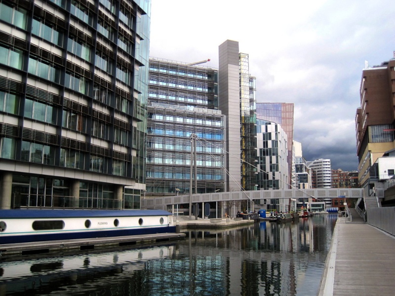
Paddington Basin today.
――――♦――――
APPENDIX III.
OBTAINING A WATER SUPPLY FROM WENDOVER
(From “On the Utility, Structure and Management of
Canals” by Joseph Townsend: published in
The Universal Magazine of Knowledge and
Pleasure, Vol. XX, July-Dec 1813.)
MOST canals are
distressed for want of water, because either they are above the
springs, or they are not permitted to derive a supply from mill
streams. A knowledge of geology will, in most situations,
relieve the engineer from distress, and teach him distinctly to what
distance he must drive a level, or to what depth he must sink his
shaft, that he may find ample supplies of water, such as no one can
claim, because they nowhere break out in springs, till they issue
either into the narrow seas, at the bottom of the ocean, or in the
great abyss. . . .
It was this knowledge, derived from Wm. Smith, which enabled
Mr. Bevan to direct his shaft into the chalk hills at Tring, by
which he secured a supply of water for the Grand Junction Canal. . .
.
In Dr. Rees’s
New Cyclopedia we have a very interesting account of the manner
in which Mr. Bevan supplied a part of the Grand Junction Canal with
water. This ingenious artist discovered, that on the north
side of the chalk summit between Tring and Wendover, different
water-tight beds in the lower chalk held up springs a considerable
height above the canal, and, in order to avail himself of these, he
began a tunnel in the upper bank of the canal near Wendover, which
he drove half a mile southward to intercept the springs in their
descent. But observing that the principal of this water was in
the winter and spring months, when the other sources were more than
sufficient for the supply of the canal, he placed a strong
water-tight valve in the most favourable part of his tunnel, which
as soon in the autumn as the canal is amply supplied from its other
feeds, he keeps shut until these begin to slacken in their supply.
The water in the immense planes of these beds of chalk
accumulate, as in a vast subterranean reservoir, the springs rise to
the level to which they originally rose, before this tunnel was
begun, that is, twenty feet above the canal, and for many weeks
after the opening of the valve in the beginning of summer they pour
forth a most surprising stream of water into the canal, which
otherwise would have found a vent miles off in the chalk vallies, or
have slowly made its way down through the joints and fissures in the
strata, to springs which issue at the bottom of the chalk below the
level of the canal.
Had the Grand Junction, like the Kennet and Avon canal, been
cut to the south-east of the chalk hills instead of being on the
north side, as it is near Wendover, and had this canal been formed
in a bed consisting of chalk rubble and of flinty gravel, Mr. Bevan
would have had no need of penning up his chalk feeders in the
autumn, in the winter, and in the spring. Of this we can have
no doubt, when we take a view of that immense quantity of water,
which flows in the thick bed of gravel, far beneath the surface, all
the way down the valley from Crofton, Bedwin, and Hungerford, to
Kintbury, Newbury, and Reading.
――――♦――――
APPENDIX IV.
THE CAUSES OF LEAKAGE AND THE ASPHALT LINING
The following text draws on research undertaken by
Barry Martin and Professor Timothy Peters
THE Wendover Arm
and the Llangollen Canal were the only significant canals built with
the primary purpose of supplying water, in the case of the latter,
to the central section of the Ellesmere Canal. It is
coincidental that they are also the only known canals where asphalt
lining was used, although in the case of the Llangollen Canal it was
only to effect a small repair.
From the outset if was realised that the ground over which
the Wendover Arm was built would prove troublesome and, as outlined
above, leakage soon became a problem that was to prove intractable
in the long term. There were probably two reasons for it:
• the porous nature of the ground through which the Arm was cut
meant that it had to be lined, and there is evidence to suggest that
this was not done properly. The original puddle clay was
sub-standard, having been excavated during the construction of Tring
Cutting and used because it was cheap and readily available.
Commercial pressure to keep the Arm open left insufficient time for
relining to be completed properly, while recent analysis of the
asphalt lining put down in 1856-7 revealed it was poorly laid and
not to the specified thickness;
• probably a more important reason is that the canal bed was roughly
on the level of several ‘seasonal springs’, which from time to time
punctured its lining. With the low rainfall experienced in
recent years it is now believed that the water table has fallen
considerably and that this problem ought not affect the restoration
work now being carried out.
In 1856, the Wendover Arm was again losing water and John
Lake, the GJCC’s Engineer, visited some reservoirs (locations
unknown) to inspect their use of asphalt as a liner. His
conclusion – supported by Sir William Cubitt, the Company’s
consulting civil engineer – was that it would be far cheaper to
repair the Arm using asphalt (£4,470) as against puddle clay
(£12,500). On this basis it was decided initially to apply a
two inch thick lining of asphalt to the section of the Arm between
Little Tring Bridge and the Wilstone Swing Bridge (¾mile ― the
swing bridge has
long since gone).
The asphalt mix that was used comprised one part of coal tar,
one part of crushed limestone, one part of sand and some coal oil.
The sand was readily available from Leighton Buzzard, the limestone
from local sources and John Bethell, owner of the Greenwich Gas
Works (now the site of the Millennium Dome), was to supply 2,000
tons of coal tar at 10 shillings and 6 pence per ton, and 6,000
gallons of coal oil at 4 pence per gallon (records indicate that he
was unable to supply more than 1,500 tons of coal tar, while other
records show that considerable less actually arrived at Little
Tring).
In June 1857, the Committee reported that the trial length of
lining was satisfactory and that it should be extended further
up-stream. By the time the asphalting had reached Drayton
Beauchamp, the mix had changed; the limestone had been replaced by
crushed chalk and no coal oil was being used, while a recent
analysis of a sample taken near Drayton Beauchamp revealed the
presence of crushed coke (coke is a by-product in the production of
town gas, and might have come from the nearby Buckland Gas Works).
On March 21st 1857, Sir William Cubitt tested and reported
favourably on the quality of the asphalt.
In application, the asphalt was prepared in situ by
crushing and mixing the ingredients, which were then heated in flat
pans over braziers and poured and spread while still workable.
However, recent excavations have revealed that, in general, the
applied thickness of the asphalt lining was one inch as opposed to
the two inches specified, while it did not extend above normal water
level on the canal banks! Only a few small examples of asphalt
lining have been discovered whose thickness exceed one inch –
notably a nine inch thick section on the tow-path side of the canal
bed near bridge No.4, which is thought might be a repair. The
GJCC Minutes record a quantity of surplus coal tar being sold off.
On May 13th 1858, Lake tested for leakage over a 3,828 yards
section and recorded a rate of 1½ locks per day compared to 15 locks
per day before relining. GJCC records indicate that the
asphalt repairs were initially considered successful, but after 12
years the Arm was again experiencing leakage, the integrity of the
lining probably have being affected by several causes including an
excessively rich lining mixture, poor construction practice, and
damage from boats, ice breaking and earth movements. Recent
excavations have also revealed that the existing clay puddle was
removed prior to the asphalt being laid, and that it received no
protection afterwards (the current restoration practice includes
putting down a considerable layer of earth ― 300 mm ― on top the
Bentomat liner in the bed, concrete blocks over the lining on the
banks up to water level, and turf above).
.jpg)
The former Whitehouses swing bridge c. 1896.
Reproduced by kind permission of Mike Bass.
Below, the same bridge after the Arm had
been abandoned -
Marsworth Reservoir in the background.
――――♦――――
FOOTNOTES |


.png)
.png)
.png)

