|
THE GRAND JUNCTION CANAL
A HIGHWAY
LAID WITH WATER.
THE CONSTRUCTION PROJECT
BACKGROUND
“The canals which intersect Middlesex are the Grand Junction
Canal, and the Paddington Canal. The former striking off from
the Thames at Old Brentford, passes the grounds at Sion Hill and
Osterley; and, running through a rich corn district near Hanwell,
Norwood, Harlington, West Drayton, Cowley, Uxbridge, and Harefield,
leaves this county near Rickmansworth. This canal, which is
navigable for vessels of sixty or seventy tons burthen, has fourteen
locks to Harefield Moor, where the level is 114 feet two inches
above that of the river Thames. From its numerous cuts, side
branches, and collateral streams, it is, beyond doubt, the most
important inland navigation in the kingdom, as it affords a direct
water communication to all the various manufacturing towns of
Warwickshire, Staffordshire, Lancashire, Derbyshire, and several
other counties. The general breadth of this canal is thirty
feet, but at the bridges it is contracted to fifteen. The
Paddington Canal branches off from it near Cranford, and is
continued on a level from thence to the dock at Paddington, the
sides of which are occupied with yards and warehouses, for the
reception and security of merchandise. The advantages derived
to the metropolis and the country at large from this canal are
likewise various and important. A third canal, called the
Regent’s Canal, stretching from the Thames, west of London, to join
that river near Limehouse, has been lately projected, and is now
carrying into execution.”
Encyclopaedia Londinensis,
Vol. XV. John Wilkes (1817)
Today, it is difficult to image the areas of Hanwell, Norwood and
Harlington, etc., being rich corn districts, or for that matter Paddington
Basin being occupied by yards and warehouses ― one warehouse
survives, although put to a different use ― but such was the landscape
through which the new canal passed and which it served.
Completed in 1805, until surpassed in 1887 by the Manchester Ship
Canal the Grand Junction was Britain’s most
expensive canal project. Originally estimated at £400,000, its eventual cost was in the region of £1,500,000. [1]
Cost overruns are not unusual in complex construction projects.
In our own age the
British Library, the Millennium Dome, the Scottish Parliament, the
Edinburgh Tramway and the Channel Tunnel are examples of
construction projects
that have significantly exceeded budget. Even the Manchester
Ship Canal, at £15,000,000, was almost three times over budget and
two years late in opening. Each of these projects attracted
much concern among its investors, as did the
Grand Junction Canal.
This chapter draws mainly on contemporary sources to provide
a feel for the financial and engineering difficulties that beset
this 18th Century ― to use today’s terminology ― ‘transport
infrastructure project’.
――――♦――――
1792 ― QUESTIONS STILL TO RESOLVE
“It was in the year 1792 that this undertaking first had its
origin. In the beginning of that year the Marquis of
Buckingham instructed Mr. Barnes, the eminent engineer, to make a
survey of the country between Braunston, in Northamptonshire, the
place where the Oxford Canal has its junction with the present
canal, and the Thames near London, in order to mark out a line of
canal, whereby the circuitous course of the Thames Navigation from
Oxford might be avoided, and the transit of goods to the metropolis
accelerated.”
Navigable Rivers and Canals,
Joseph Priestley (1831)
When Barnes completed his survey in 1792, questions still to resolve were the line
that the Canal should follow south
of Two Waters (Hemel Hempstead) and the location of water sufficient
to supply the Tring summit. Some
of the Grand Junction Canal Company’s earliest published circulars
address theses issues.
One of the first recorded shareholder meetings, [2]
convened by the Earls of Essex and Clarendon, took place at the
Essex Arms, Watford, on 20th October, 1792. The main business
of the
meeting was to consider the plan of the Canal and decide whether it
should reach Southall through Watford and Harrow, or take a longer but more favourable line along the Gade and Colne
valleys through Rickmansworth and Uxbridge. Having inspected both
routes, Jessop favoured the
latter and supported by Barnes recommended accordingly. The
Rickmansworth route being accepted, the meeting went on to vote in
favour of a short branch to link Watford to the main line, which, on
account of their first decision, now
bypassed the town. On the following day the Rickmansworth route was
again approved, this time at a meeting chaired by William Praed and held at the County Hall,
Northampton. Jessop
reported to the Committee that there were many reasons for
preferring the Rickmansworth route. These are unrecorded, but it is
likely that a sufficiency of water was prominent among them.
Although water supply was an issue that affected the entire Canal,
supplying the Tring summit was to prove particularly challenging. Writing in
1805, the civil engineer Thomas Telford, who had recently inspected the
Canal, referred to water supply in the
introduction to his report:
“. . . . the Line of Canal has unavoidably been carried over a
country, in many points of view unfavourable for Canal operations.
The line of the canal passes over and skirts along some of the
highest ground in the central parts of England . . . . this
circumstance has subjected the canal to the inconvenience of two
summits, and has rendered the supplies of water more difficult to be
procured than when canals are carried upon lower levels, or are
connected with more mountainous countries. . . .”
Supplying the Tring summit with water appears not to have been
investigated thoroughly at the outset, suggesting that the level of
traffic that built up following the Canal’s opening was
greater than anticipated. In his report to the Committee of 24th October
1792, Jessop expressed the opinion that the flow from Bulbourne
Spring together with that from the “Tale at New Mill” (Tring Brook)
would, between them, supply 30 lockfuls a day and that any
deficiency could be made up by steam pumping from a reservoir,
although none had then been planned; some
ten years were to elapse before the first of the Tring Reservoirs
was opened at Wilstone. [3] Another important water resource is the Wendover Stream; diverting its
abundant supply to the Tring summit appears not to have been
contemplated at this stage, for Jessop makes no mention of it and
neither is the supply channel (later to become the 6¾-mile Wendover
Arm) shown in the deposited plans.
In retrospect, Jessop’s opinion that “the
practicality of getting water sufficient is beyond doubt” proved over-optimistic,
for despite the resources that have been applied down the years to
flooding the Tring summit, water shortage has continued to pose a
problem. At the time of writing, the Tring summit was last
closed through water shortage in February and March 2012 ― this was inconvenient,
but during the Canal’s commercial heyday drought could seriously hinder the
passage of trade (and canal families’ piecework income):
“Between Marsworth and Boxmoor, on the important canal which
connects London with Braunston and Leicester, there are 50 pairs of
barges waiting for water to float them through the locks. This
block is the worst effect of the drought in Hertfordshire and
Buckinghamshire. It is causing serious delays in the London
supply of all kinds of merchandise — coal and ironware from the
Midlands, new corn from some of the arable counties, condensed milk
from Aylesbury — and in the Midlands supply of sugar, tea and other
commodities in bulk from London. Heroic exertions on the part
of the Grand Junction company’s engineers and servants do not enable
more than 80 to 90 barges a week to pass over Tring Summit, whereas
in times of plentiful water 130 pass.”
Bucks Herald, 11th October, 1902.
Telford also identified in his survey a number of sections where the water
that had been procured was being wasted through leakage. One example
that he gave was to the south of the Tring summit:
“it will be chiefly in the upper part of the line in this
district, that is, between Cow Roast and Box Moor, that much
attention and expense will be required, in order to prevent
leakage.”
In fact it was along the section of the Canal to the south of Boxmoor where leakage was later to bring the Company into conflict
with the local water millers, a conflict in which Telford was to
become involved.
――――♦――――
1793 – WORK COMMENCES
Following the passage of the first Grand Junction Canal Act (30th
April, 1793), construction began promptly. By December of that
year the Committee was able to report that “the works on the
Grand Junction Canal are proceeding with an astonishing rapidity,
and the number of men now daily employed amounts to 3,500”. However, their report goes on to say that expenditure was greater
than anticipated and it reminded subscribers to settle promptly the
calls on their partly paid shares. This was an early indication of
the cost overruns that were to affect the project and that required
recourse to Parliament on several occasions for authority to raise
additional capital. Jessop had already informed the Committee that
his construction estimate included an allowance for the inflationary
pressure on wages from competing canal projects (this was the period
of canal mania):
“I have thought it necessary to make very large allowances for
the increase and increasing price of labour, in consequence of the
numerous works of this kind now in agitation, and I have full
confidence that the expense will not exceed the estimate.”
Report to the Committee,
24th October, 1792 – William Jessop
But what Jessop could not have allowed for was the additional
inflationary pressure of the French Wars (1793-1815) together with the
cost of function creep [4] that so often affects major
projects. He did, however, inform the Committee that even if
the project was completed at twice his estimated cost, it would
still be worth doing.
――――♦――――
1794 – WORK PROGRESSES
By May 1794, Jessop was able to report good overall progress.
The canal from Brentford to Uxbridge was almost complete and he
expected it to open by late September, although shortage of
labourers [5] during harvest-time was a problem, which probably
accounts for this section being opened (with the usual celebrations)
rather later than Jessop had estimated:
“That part of the Grand Junction Canal from the river Thames,
near Brentford, to the town of Uxbridge, was opened on the 3rd
instant, for coals, and all sorts of merchandize to be navigated
thereon; comprising upwards of twelve miles of this great
undertaking. The opening of this part of the Canal was
celebrated by a variety of mercantile persons of Brentford,
Uxbridge, and Rickmansworth, and their vicinities, forming a large
party, attended by a band of music, with flags and streamers, and
several pieces of cannon, in a pleasure-boat belonging to the
Corporation of the city of London, preceding several Barges laden
with Timber, Coals, and other merchandize, to Uxbridge. After
which the party dined at the White Horse Inn.”
Northampton Mercury,
15th November, 1794
Work was also progressing on the northerly of the Canal’s two
summits at Braunston. The Braunston summit was one of the early
points of attack, work commencing there in May of the previous year:
“One part of the Braunston canal, which is to form the Grand
Junction, was begun last week with great spirit. Three hundred
and seventy men were paid on Saturday night, and more hands are
arriving every day. Another part will shortly be set about by
Mr. Clifton, with his new machine for saving three fourths of manual
labour, in cutting and removing earth, &c.”
Northampton Mercury, 25th May, 1793
It is doubtful if Mr. Clifton’s “new machine” was a success,
for there is no further mention of it.
The summit level is just over 3 miles long (comparable to that at
Tring), 2,042 yards of which passes through the Braunston tunnel, which
Telford later described as “being in a tolerably straight direction”,
a reference to the slight S-bend in its alignment. Because the
ground in the vicinity was impervious clay rather than absorbent chalk, water supply
was not to be the challenge that it was at the Tring summit.
The 1793 Act also authorised the construction of a 1½-mile branch
from the summit to Daventry. Jessop estimated that it would require eight locks to cope
with the 52 feet difference in levels and cost £6,000 to build, but
he could offer no opinion as to the branch’s commercial viability.
Because of its falling gradient from the town, the Daventry branch
would have supplied the summit with water,
but although its position is shown in the Canal’s deposited plans it
was not
built. [6] Instead, the Braunston summit is supplied
with water by what Telford later described as “small
rills on the Braunston side of the summit” and by a
feeder channel from Watford Park, which joins the summit near Welton. These feeders worked in
conjunction with a small reservoir (which no longer exists) near the northern end of
Braunston Tunnel and the much larger
Drayton Reservoir, opened in
1796, which lies to the north west of Daventry.
In his report, Jessop expressed reservations about the quality of
the bricks being made for Braunston Tunnel [7] and
the quantity; “as is commonly the case at the outset of
brick-making, they [the brick-makers] want flogging to their
duty”. A section of canal to the east of the tunnel had been flooded and
was being used to transport bricks. Work on the cuttings was
progressing well, as were the high embankments at Weedon, Heyford
and Bugbrook (the great embankment between Wolverton and Cosgrove was a late addition
to the original plan). Work had also begun on the Blisworth Tunnel, but
too little had been done to give any indication of the setbacks yet
to come. The Wendover Arm was by now seven-eights complete (so
was probably complete by the end of 1794); here, Jessop
draws attention to the “very leaky” terrain over which it was
being built, a portent for the future.
Jessop also refers to progress on the Tring cutting (“The Deep
Cutting at Marsworth”), where the ground along the line had been cut
to an average depth of five feet, sufficient to make Jessop hopeful
“that this heavy piece of work will be executed at an expense
considerable less than was first expected” ― it was not to be.
 |
|
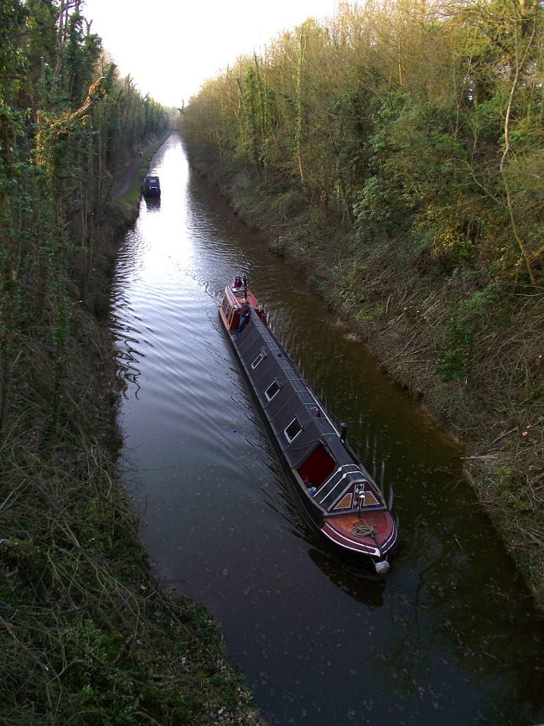
Tring Cutting,
looking north from Marshcroft Lane bridge (No. 134).
|
――――♦――――
1795 – PROJECT CONCERNS
By August, 1795, the Committee was becoming concerned about escalating
costs. To date, the value of work on the Canal amounted to £296,000
and Jessop estimated that a further £312,000 was needed to complete
construction, of which monies owing and assets in hand amounted to
£177,000, leaving a deficit of £135,000.
In explaining the position to their shareholders, the Committee
pointed to a number of unforeseen expenses, some of which had been
imposed by Parliament, such as a change in the method by which the
canal banks were formed (£17,000) and an additional duty on bricks
(£7,200). Other items included the purchase of water mills (to
obtain their water rights, £10,500), construction of reservoirs
(£7,000) and an alteration to the line of the Canal to pass through Cassiobury and Grove Parks (£9,000),
this being offset by Parliament authorising an additional levy of
two-pence per ton “for and in
consideration of the more constant, speedy, and safe communication
proposed by the said deviation”. [8] The
Cassiobury/Grove Park deviation brought the Canal closer to Watford
― to which a branch was then planned ― and despite the high cost of
the land, it probably cost little more to build than
the original route, which would have required an aqueduct across the
Bulbourne and a tunnel at Langleybury.
In addition to the financial impacts of changes and additions to
specification and the inflationary pressures of the age, land was
also proving more expensive than anticipated:
“The price of materials, the expense of carriage and provender
for horses, have been much enhanced; and the dearness of provisions
has greatly enhanced the price of labour. And the price which hath
been paid for the land purchased (in general) much higher than the
same had been calculated upon. Before beginning the work, Mr Jessop
found it advisable to make the locks something larger than they were
first intended, and to make the tunnels something wider and higher;
the canal has also been made five feet in depth, instead of four
feet six inches, as computed in the original estimate.”
GJCC
Statement of Expenditure, 6th August, 1795
A further expense to find its way into the report was “the
payment of interest to Proprietors out of capital stock”.
During this stage of the Canal’s construction, shareholder received
5% p.a. interest
payable on the nominal value of their shareholding, with interest
payments being funded mostly from capital due to the Canal’s very
limited earnings at this stage. The Company projected that between midsummer 1794 and March 1798,
interest payments to subscribers, if continued, would account for
£75,000 and that suspending them was “a measure highly expedient”. In the event, the Committee decided to credit subscribers’ accounts
with the interest owing, but to suspend payment until directed by a
future General Meeting.
And so began the process of finding ways and means of financing the
Canal’s construction, which were to continue for the remainder of
the project. This involved containing costs ― even Jessop’s role as Chief
Engineer was eventually dispensed with (ostensibly) as a cost-cutting measure
― increasing tolls, raising further capital by selling shares, and
raising loans, much of which required the authority of further Acts
of Parliament. These measures commenced later that year with an
application to Parliament to raise a further £225,000 of share
capital. [9]
――――♦――――
1797 – ESCALATING COSTS
|
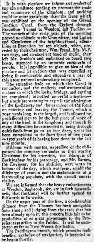 |
|
Northampton Mercury, 5th June, 1796. |
Every major construction project has its critics and that
to build the Grand Junction Canal was no exception. In 1797, a long pamphlet appeared
entitled “Observations on the present state of the Grand Junction
Canal, submitted to the Attention and Consideration of the
Proprietors”. In it, numerous allegations were laid against the
Committee implying mismanagement and incompetence. The author cited,
as evidence, the heavy overspend on budget, money wasted on wharfs
and tunnels (most notably on the Blisworth Tunnel, which was by then in limbo) and the heavy expense of building the Tring
cutting. Overall, the pamphleteer considered the Committee to be “inert
and inexperienced”, pointing to declining investor confidence
and the fall in share price from a £90 premium to £30 to support
that view. To make the best of a bad job, the writer recommended
that the Canal’s “upper [southern] end ought to stop, and the lower end
prosecuted as far as the inland coal trade would extend”.
The pamphleteer’s allegations probably contained sufficient germs of
truth to encourage the Committee to mount a vigorous defence. At the
General Assembly held on 7th November 1797, it was resolved to
publish a rebuttal of the main allegations, preceding which the
Committee assured their shareholders that they had “conducted the
affairs of this Company with the strictest zeal and integrity”. In their response, the Committee gave credence to the charge that
costs were continuing to exceed budget. Again, they were at pains to
attribute overruns to additions to their original plan (some of
which had been heard before), such as the need for the Aldenham
Reservoir, [10] for aqueducts across the Colne and
a change in the line at Harlington, while other unexpected costs
stemmed from additional linings for the Canal, clearing the
Braunston Tunnel workings of quicksand “which from the borings
there was no reason to expect”, and “widening and deepening
the canal beyond the original design, and the consequent increase of
expense in the width of every bridge”. [11]
The inflationary pressures of the French Wars were also
beginning to bite, with military needs competing for scarce manpower
and manufacturing resources. As the Company explained, procurement was
being affected by “the difference of the War price for all labour
and materials, when compared with the sums estimated for them in
profound peace”. But on the bright side, the Committee
report
that work on the Tring cutting and on short sections to the north
and south of it were nearing completion, and that even in its
unfinished state the Canal would soon generate revenue estimated at
£20,000 p.a.
A section of the Committee’s response also provides an interesting
explanation of the sequence in which the various sections of the
Canal were built. In addition to the commercial considerations ―
i.e. what sections were likely to generate the most
revenue soonest ― there was the perennial problem of water
supply to contend with, for an insufficiently flooded canal is near
to, or completely useless. In explaining why work on the section
south of Blisworth tunnel should not yet go ahead, the Committee
pointed out that not only were twelve locks required to take the
Canal down to Cosgrove, but until the Blisworth tunnel was completed
there would be insufficient water to flood them. A section near
Stony Stratford, about five miles in length, could have been
completed but there was no commercial sense in so doing, while the section from Cosgrove up to Fenny Stratford
could not be flooded until it had been reached by the Canal
bringing water down from Tring.
――――♦――――
BARNES REPORTS ON PROGRESS
The Committee supplemented their rebuttal of the mischievous
pamphlet with a report [12]
from Barnes on the present state of construction. This is
revealing. To the south, the Canal was
now open to Kings Langley and would shortly reach Two Waters (Hemel
Hempstead), but Barnes then moves on to reflect on “the great
difficulties, delays and impediments” to construction being caused
by “the immense quantity of water springing from the earth at the
locks”, while the porous ground over which the Canal was being
built in the vicinity of the Nash and Apsley paper mills required
it to be lined. In later years, leakage along this section was
to result not only in the Company paying heavy damages
to the paper manufacturer John Dickinson, whose water mills had suffered
in consequence, but in an alteration to the route followed by the
main line. North of Two Waters, work had begun cutting the
section up to the Tring summit and much building material (bricks
and timber) had been deposited along the route in readiness. Barnes
was optimistic that the ground over which this section was to pass
would prove favourable.
Work had commenced at the outset on the Tring summit due to the
heavy excavation required, about half of its 3-mile length being
in a cutting some 30ft deep in places. Although the Wendover Arm
seems not to have featured in the original planning (1792), its
importance in diverting the Wendover Stream 6¾-miles along the 394ft
contour to the Tring summit must soon have been recognised. The
Arm was probably complete by the end of 1794, but in any event well before the
southern section of the Canal reached the Tring summit
early in 1799.
In his report, Barnes informed the Committee that work excavating
the Tring cutting was progressing well, but two problems had been
encountered. A section of about 500yds was found to be extremely
waterlogged, causing slippages in the adjacent walls of the cutting. These required drainage headings to be driven into the banks behind
the slips to lead off what Barnes describes as “a great quantity
of water”. Further south along the summit, a section of the
Canal passed over ground that was found to contain gravel and was
porous. This Barnes planned to deal with using the earth from the
slips, which was found to be suitable for lining and which, he says,
“I intend taking away with barges”, implying that by this
date part of the summit was already flooded.
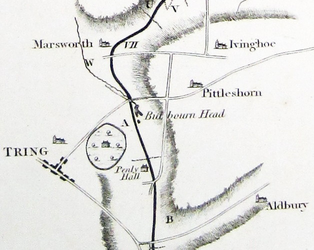
At the northern end of the summit, the deposited plans show a
rather different route was intended from that eventually taken. The
Canal plan and section show the summit pound continuing
northwards along the contour from a location in the vicinity of Marsworth top
lock (No. 45) to a point about ¼-mile to the north of Lower Icknield
Way. From here, the Canal was to descend via a closely spaced flight
of ten locks [13] to the east of Marsworth Parish
Church to join the present route. However, the Canal as constructed follows a
line to the west of Marsworth Parish Church, descending the incline
from Bulbourne along the course of the northern outflow of Bulbourne
Head (or Bulbourne Water) via the flight of seven locks
seen today. The
Tring summit pound is thus about ½-mile shorter than originally
planned, but why this change was made is unknown.
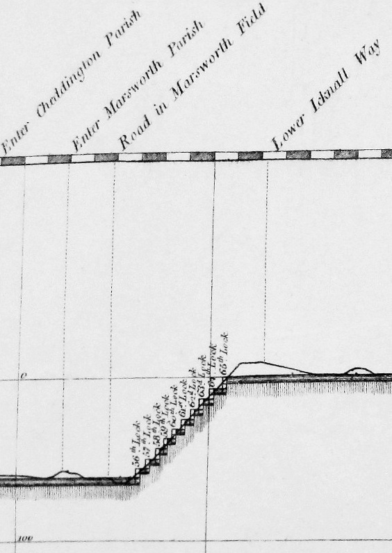
|
Section and plan showing the
variation in the course of the Tring summit at its northern end.
The Canal, as built, passes to
the west of
Marsworth Parish Church,
not to the east as shown, commencing its descent from the summit
well to the south of Lower Icknield Way. |
North of the Tring summit, Barnes
believed the ground to be “upon trial, exceedingly favourable”
stating that he expected the cost of the Canal per mile would be
comparable to that of the section between Uxbridge and Two Waters. Work had already begun in the vicinity of Marsworth and Cheddington,
where Barnes reported finding plenty of
good clay for brick-making, and he was optimistic that the section
to Fenny Stratford would be completed at the same time as the Tring
summit was reached from the south. He then moves on to report
progress on the problematic Blisworth Tunnel.
The Blisworth tunnel was recognised to be one of Grand Junction
Canal’s three major engineering challenges, [14]
construction having commenced in 1793. Trial boring along the line
of the tunnel from the hill above failed to reveal that the strata
through which the tunnel was to pass dipped in the centre. The
effect of this was to cause the horizontal tunnel to move out of a
layer of impermeable clay and into one of porous, unstable rock
which, together with the layer of impermeable clay beneath it,
formed a subterranean reservoir.
By the end of 1795 the tunnel had moved into this water-bearing
stratum, resulting in such severe flooding in the workings
that excavation came to a virtual standstill. The Committee was then
faced with the decision of whether to restart the tunnel on a
different alignment, the option favoured by Barnes, or take the
Canal over Blisworth Hill using a system of locks, reservoirs and steam
pumping, the solution favoured by Jessop. Faced with their
professional advisors’ conflicting views, the
eminent civil engineers John Rennie Snr. and Robert Whitworth were
engaged to
assess the situation and give an opinion. Following inspection and
deliberation the pair decided in favour of the tunnel and the
Committee ruled accordingly, placing Barnes ― who must already have
been carrying a considerable burden of other responsibilities ― in
direct control of the works.
In an age when large-scale tunnelling was in its infancy, Jessop’s
recommendation was undoubtedly the safer, although it would have
brought its own costs and problems. Locking over Blisworth Hill
would have caused a significant delay to traffic added to which
would be difficulty in
ensuring a sufficient water supply at the summit; there was also the cost of
operating and maintaining the locks and pumping system. On the other hand the tunnel has been much
affected down the years by distortions caused by movement in the
interface between the clay and oolite layers, which has led on
several occasions (most recently in the late 1970s and early 1980s)
to closure while expensive repairs and rebuilding was carried out.
By November 1797, the tunnel’s workforce had been deployed to more important
construction
further south, work being continued, at Barnes’s insistence, by a
skeleton team who
continued to drive headings into the hill to carry off the large
amount of subterranean water (a pilot heading later became the
standard tunnelling technique). Barnes
reports that this essential work was proceeding, and he recommends
that full-scale activities recommence by the following spring in
order that the tunnel “may be completed without loss of any time”.
――――♦――――
1798 – FURTHER PROBLEMS AT THE TRING SUMMIT
By June 1798, the advancing Canal had reached Berkhamsted from where
Barnes submitted a further report. In it he informed the
General Assembly that by the end of September he expected the Canal
to be navigable from Brentford to Wendover. He then returned to a
problem described in his previous report, “that the deep cutting
at Tring summit hath occasioned a great additional expense, by the
various slips that have unfortunately happened” and he goes on
to describe “the bottom of the Canal is in many instances so
soft, that a staff may be run down eight or ten feet perpendicular
below the bottom level of the canal with great ease”. The
condition of the ground through which the cutting was being driven
was probably due, in part, to it passing along the course (as it
then was) of the River Bulbourne, and partly to cutting into the
aquifer from which rose some of the springs in the locality, the
Bulbourne Springs and Clarke’s Spring being close to the line of the
Canal.
When Barnes undertook his survey of the Braunston to Brentford
route, he was faced with the problem of how best to take the Canal
over the barrier imposed by the Chiltern Hills. This 47-mile chalk
escarpment extends north-eastward from the Wiltshire Downs and the
River Thames towards the Dunstable Downs and Luton; skirting around
it was not an option. Of the slight depressions in the ridge, Barnes chose
to take the Canal through the Tring Gap. The problem was then to obtain sufficient water to
supply the summit level and the declining gradients to the north and
south.
The water resources in the immediate vicinity of Tring
comprised, principally, four springs, at Miswell, Frogmore, Dundale
and Bulbourne Head. The outflows from Miswell and Frogmore powered a
watermill at Gamnel, which the Company bought,
diverting its millstream (the Tring Brook) into the Wendover Arm. It
is unclear how the Dundale outflow was treated, but today it flows
underneath the Wendover Arm into Tringford Reservoir. As for
Bulbourne Head:
“About two miles from Ivinghoe is a place called Bulbourne,
belonging to John Sear, Esq. of Tring Grove. Here is said to
be the original source of the river Thames: there are two springs,
which divide within ten yards of each other, one running due east
and the other west. [15] Mr. Sear has
made a fine canal for a pleasure-boat, one mile in length.”
Topography of Great Britain,
George Alexander Cooke (pub. 1817)
At this date, the two springs ― known together as Bulbourne Head or Bulbourne
Water ― formed a considerable lake and the source of the River
Bulbourne, which today rises several miles to the south in the
vicinity of Dudswell. The deposited plans show “Bulbourne Water,
purchased of Mrs Mary Seare” [16] to lie along
the Canal’s summit route near the present day hamlet of Bulbourne. The 1793 Act gave the
Company authority to purchase part of Mary Sear’s
“plantation”, [17] providing that the
Company built a dam, fitted with a sluice, which the lady could use
to discharge water into the Canal or hold it back, which suggests
that she made use of the “Bulbourne Water”, perhaps as Cooke
seems to think, for leisure purposes. A further provision in the Act
also forbade the Company “to erect any lock
within the distance of One Mile on either side of the Bulbourne Head
aforesaid, without the consent of Mary Sear . . .” but the
reason for this provision (and others like it elsewhere in the
Grand Junction Canal Acts) are lost in time. It might,
however, explain why the original plan was to descend from the
northern end of the summit from a point on Lower Icknield Way to the
east of Marsworth Parish Church, rather than from Bulbourne
Junction.
Today, the dried-out depression once occupied by Bulbourne Water is
plainly visible in satellite mapping, with the Canal crossing its
western end. The reason that Bulbourne Water is now dry
stems from the draining effect of the Canal cutting on one side, and
of the London & Birmingham Railway cutting (constructed some 40
years later) on the other. It appears that during the construction of the railway
cutting, it was anticipated that the feed to Bulbourne Water would
be intercepted . . . .
“The
excavation for the London and Birmingham Railway, through
Tring-hill, is proceeding rapidly. Mr Townsend the contractor
has upwards of 500 men employed besides a great number of horses.
It is expected they will intercept the
‘Bulbourne
springs’
when they get deeper. These springs at present come directly
into the Grand Junction Canal. There is only one fault to be
found with the work in this neighbourhood, and that is the steepness
of the banks, they being only, for the excavations, in the ratio of
nine inches horizontal to one foot perpendicular. In the event
of a sharp frost, this ground, which is a sort of chalk rag, will
slake down like lime, and will consequently be a great nuisance
after the road is finished. The banks of the Grand Junction
Canal, in the deep cuttings collateral with the railroad, are more
than one to one, yet the slips which have occurred after a sharp
frost have been prodigious.”
The Mechanics' Magazine, Volume 23, 1835
. . . . and such was the case. Robert Stephenson, the railway’s civil engineer,
was later to report:
“. . . . The Tring cutting on the L and B R/Way presents another
forcible example of the constant and rapid absorption of water by
the chalk. In the execution of that cutting a very large
quantity of water was encountered, notwithstanding the situation was
on the summit of the chalk ridge, forming the actual brim of the
basin, where it could not be supplied with any water but such as
fell upon the immediate neighbourhood, yet it yielded upwards of one
millions gallons per day, and continues to yield an extraordinary
quantity up to this hour, without any sensible diminution.”
Minutes of proceedings of the Institution of Civil
Engineers: Volume 90, Part 4
Like Barnes before him, Stephenson had cut into the aquifer that fed the
Bulbourne Springs. The
“large quantity of water” to which he refers is now channelled
from the railway cutting through a heading to enter the canal
summit to the south of Marshcroft Lane Bridge. During the drought of
1934, Edward Bell, the Company’s section
inspector, reported that he was able to walk through the dried out
heading, but not wishing
to retrace his steps he emerged into the railway cutting. In his
memoir he mentions, as he climbed up the steep embankment, “feeling
very scared as an express train thundered along below”.
And so the Tring cutting was driven through waterlogged ground, with
its walls slipping in places. In his report, Barnes again explains
the technique of driving headings into the cutting walls to carry
off the water, but he now describes a further technique, that of
“piling, stretching and campshooting” (sic.) with the canal bed
being “planked very close”. Following World War I, the banks
along Tring summit were strengthened to protect against erosion. In
his memoir, Edward Bell recalls that:
“. . . . considerable difficulty was experienced in the Tring
Summit because halved tree trunks had been laid in the bed of the
canal across the waterway at intervals with timber piles at each end
of the tree to prevent the toe of the high offside bank from
encroaching into the waterway.”
Memoirs of a British Waterways Canal Engineer,
Edward Bell
No doubt Bell had encountered Barnes’s piling, stretching,
campshooting and planking.
――――♦――――
1798 – WORK PROGRESSING, COSTS ESCALATING
By June 1798, between two and three miles of canal had been
completed north of the Tring summit, about one million bricks had
been made and a team of nine moulders were at work making more. Barnes recommended to the Committee that the cutting northward
should proceed swiftly to meet with “the Great Chester Road”
at Fenny Stratford, thereby capturing the road transport to London and
increasing the Company’s toll revenue accordingly. This would then
free up manpower resources to enable “a strict attendance to the
execution of the [Blisworth] tunnel”, which Barnes
believed could be completed in two years “or thereabouts; then,
if the tunnel should not be early proceeded upon, the want thereof
will be so great an impediment to the navigation, that the delay
will hereafter be very much lamented”; in that assessment he was
undoubtedly correct, although the impediment would be mitigated to
an extent by Jessop and Outram’s horse-drawn railway over Blisworth
Hill.
Barnes’s report (2nd June, 1798) was accompanied by a summary of the
Company’s cash account at 1st May, 1798:
| Receipts |
… … … … … … … … … … … |
|
£620,687 |
|
| Payments: |
|
|
|
|
| |
Purchase of land, salaries, etc |
£143,458 |
|
|
| |
Payment of interest to subscribers |
£40,061 |
|
|
| |
Building cost of 47 miles of Canal |
|
|
|
| |
Reservoirs, Feeders, etc. + WIP |
£429,687 |
£613,206 |
|
|
|
Balance |
|
|
£7,481 |
| |
Monies owing |
|
|
£43,226 |
| |
|
|
|
|
| |
Funds available |
|
|
£50,707 |
That only half of the 93½-miles of canal had been opened by this
date was a clear indication that the funds then available were
insufficient to complete the project and that further capital was
needed. And so the Committee announced their intention to raise
£150,000 of 5% loan stock, convertible to shares by 25th March, 1803
(most of it was). But the under-estimation of construction
costs continued, the
outcome being that in later years the Committee were to return to
their shareholders for further capital in one form or another until
by June, 1804, the Company’s capital account exceeded £1.3M. Against
this background, it becomes easier to understand why the construction
of some of the planned branch canals were delayed or not proceeded
with.
In the meantime, the continual haemorrhaging of capital through the
5% p.a. interest payments on subscribers’ shareholdings, ceased.
This decision was taken at the General Meeting held on 6th November 1798,
by which time the cumulative interest already paid exceeded £40,000. At this
meeting it was decided to convert the interest due for the 12 months
ending midsummer 1798 into “a Mortgage or Assignment of the tolls
of the said Navigation”, at 5% p.a. interest (a further loan),
and that following midsummer 1798, shareholders would instead
receive dividends to be paid out of toll revenue after deductions
had been made to cover operating expenses.
Since the first sections of the Canal had been opened for business,
[18] toll revenue had been rising gradually,
assisted by Parliament’s approval of additions and increases to the
toll rates laid down in the 1793 Act. The Act of 1805 [19]
granted the Company further relief by lifting another provision of
the 1793 Act, that which permitted toll-free use of the Canal by the
armed forces. Before the coming of public railways, there are
numerous newspaper reports of the Grand Junction Canal being used
for military transportation, undoubtedly added to by the needs of
the French Wars. Lifting this exemption would have provided a
useful boost to revenue.
――――♦――――
1799 – THE OUSE VALLEY AND BLISWORTH HILL
By June 1799, the Committee was able to report that they had
inspected 64 miles of completed Canal, which despite the severe
winter just passed they found to be in satisfactory condition. Barnes was also able to report (probably in May 1799) that work on
the section between the Tring summit and Fenny Stratford was
progressing “very rapidly” and he remained optimistic that
the terrain onwards to the temporary terminus to be set up to the
south of Stoke Bruerne “appears so very favourable for execution”. Furthermore, the problem of water supply would there be met by the
drainage water issuing from the Blisworth Tunnel workings, which
together with other sources was judged ample “to supply the locks
equal to any trade that can be expected to arise”.
The major obstacle between Fenny Stratford and Cosgrove was the
valley of the Great Ouse, which lies across the line of the Canal
and is the lowest point between the summits at Tring and Braunston.
The Canal was originally planned to descend into the river
valley via a flight of four locks and to ascend the opposite side by
a further four lock flight. Locking into and out of the river valley would
have delayed traffic added to which, because the river was to be
crossed on the level, there was the potential for serious disruption
when it was in flood, which occurred from time-to-time. The locks on
the southern side of the valley would also have increased the demand
for water from the Tring summit where it was often at a
premium, this lockage water being lost into the Great Ouse.

|
An artist’s impression of the
Cosgrove
Embankment under construction, showing Jessop’s aqueduct and
the original scheme for crossing the valley. |
In 1799, Barnes suggested to the Committee that, as an alternative,
the Ouse valley might be crossed by a high embankment in which a
section would contain an aqueduct to carry the Canal over the river. This would avoid the problems inherent in the planned system of
locks, but such a substantial earthwork ― approaching a mile in
length ― would take about two years to build. The Committee decided
in favour of the embankment and aqueduct, but to avoid delay to the
opening of the final section of canal (Fenny Stratford to Stoke
Bruerne) while they were being built, they decided to press ahead
with the construction of the two planned flights of locks, but to
build them as temporary structures. [20] They were
completed in September, 1800.
The progress now being made towards Cosgrove laid bare the obstacle
of Blisworth Hill. Other than excavating the drainage headings,
work on the tunnel had been dormant since March 1797 when the
original alignment had been abandoned. It was now apparent that the
new tunnel would not be complete in time to meet the main section
of the canal then advancing rapidly from the south. Writing in 1797,
William Pitt described the problem that the Committee faced:
“The trade of this canal makes a stop at Blisworth at present;
very considerable difficulties having arisen in the execution of a
tunnel, or excavation, of about two miles in length, under the high
ground at Blisworth: the difficulties arise from the under stratum,
on a line of the tunnel, which consists of a calcareous [21]
blue marl, extremely friable on exposure to air or moisture; and,
the springs being powerful, the water, on coming in contact,
converts this marl into liquid mud, which has occasioned the blowing
of the shafts and sheeting of the tunnel; and some time must elapse
before it can be finished and rendered navigable.”
The
Agriculture of the County of Northampton,
William Pitt (1797)
As arrangements currently stood, it was realised that Blisworth Hill
would impose an increasing barrier to commerce, particularly in shipping
the southbound cargoes of coal that were building up at the
‘port’ of Blisworth:
“Pit-coal from the Staffordshire collieries, is now brought
plentifully to Blisworth, by the Grand Junction canal . . . . At
Blisworth are erected extensive wharfage and warehouses for goods,
two new inns on the canal banks, and there are five or six thousand
tons of coal in stacks on the wharfs; a large number of canal boats
and trading boats in the port, and two new ones on the stocks,
building. A considerable hurry and bustle of business is created
here by this canal.”
The Agriculture of the County of Northampton,
William Pitt (1797)
Apart from coal, toll records show that among the other bulk
commodities that were now being shipped by canal were stone, timber,
pig-iron, salt, bricks and slate ― indeed, in the years that
followed the Canal’s opening, traditional
thatched roof coverings in its locality were gradually replaced with slate. The
build-up of goods at the transhipment wharfs on either side of
Blisworth Hill was such that the
existing road [22] between them was considered
inadequate to cope with the increasingly heavy flow of traffic. To
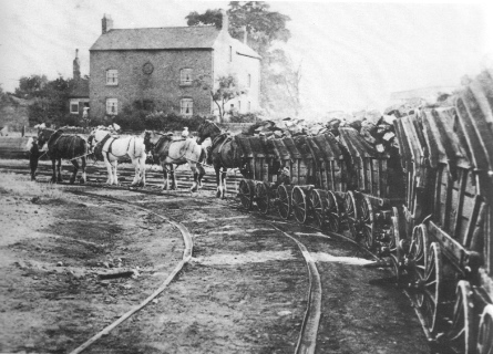
this end, Jessop investigated the feasibility and economics of
constructing a double-track horse-tramway. In his
report of April,
1799 (counter-signed by Barnes), he submitted a detailed argument in
favour of a rail link to run from Blisworth “to the crossing of
the Towcester River”, [23] a distance of some
3¼-miles at an estimated cost of £24,000. The Committee
endorsed the plan, informing the shareholders that compared with
road transport the facility of an “iron road” was “beyond
calculation”. [24]
|
 |
|
The Little Eaton
Gangway, an example of a
horse-drawn
tramway. |
Benjamin Outram (1764-1805), canal engineer and the leading
practitioner of early railways, [25] was
contracted to construct the line. The form of track that he used was
L-shaped cast iron plates fastened to stone sleepers with oak
pegs, the sleepers being laid on a bed of gravel and small stones. No record of the line’s gauge has survived, but it is thought to
have been 4ft 2ins, a gauge favoured by Outram for other of his
railway projects. The rail wagons were fitted with flat rather than
the flanged tyres used by later rail vehicles; these were guided by
the uprights of the L-shaped plates, the plates’ horizontal sections
supporting the wagon’s weight. Flat tyres also permitted the wagons
to be run off the rails at either end of the line and hauled across
the wharfs where ― at least in the cases of coal for nearby
Buckingham ― they were hoisted into a narrow boat. The tramway appears to have been in operation by June of
1800, for Company advertising of that date refers to “. . . . a
temporary cast-iron rail road has been adopted, until the tunnel and
locks could be completed . . . .”
Earlier that year, the Canal had reached Fenny Stratford where the
usual ceremonial opening took place to mark the occasion:
“The Grand Junction Canal was on Wednesday opened for barges from
the Thames at Brentford, to Fenny Stratford, in Buckinghamshire, and
early in the morning a number of boats departed from Tring, in
Hertfordshire, at which place the canal has been completed these two
years past; about one o’clock they passed through Leighton, in
Bedfordshire; and a short distance before they reached Fenny
Stratford the Marquis of Buckingham, accompanied by a number of
friends and principal proprietors, attended by the band and a party
of the Buckinghamshire Militia, met them. — They then went in grand
procession to Fenny Stratford, where they were received with firing
of canon belonging to the town and other demonstrations of joy. The
Marquis and the proprietors retired to the Bell Inn to dinner”.
Jackson’s Oxford Journal,
31st May, 1800
――――♦――――
1800 – BLISWORTH TUNNEL
Work had now commenced cutting from the River Tove
towards Cosgrove to meet the Canal advancing from the south. When
exactly the two sections met is unclear; the respected canal writer
John Priestly gives only the year, 1800, [26] but
other known dates suggest that, if this was so, it was late in the
year. By the following June, the Company was
advertising the canal to be complete from Brentford to Braunston,
with conveyance over Blisworth Hill by way of an “iron railway”.
It is unclear whether this advertising was purely to drum up trade, or an
indication that the Canal did not open for business immediately.
During the summer of 1800, advertisements appeared in the press
inviting the public to subscribe to a £100,000 5% convertible loan,
its principal stated purpose being to fund completion of the
Blisworth tunnel. [27] Since work on the tunnel
had been abandoned in March 1797, the only activity had been to
drive a narrow brick-lined heading beneath the alignment of the
future tunnel to drain the water that had led to the original
workings being abandoned. With the Canal now complete in other
respects, attention was turned to the tunnel’s excavation.
Plans for the tunnel [28] were drawn up by Jessop
and the work put out to tender. The successful bidder was a
consortium, whose rate was £15 13s. per yard, payments to be made
against completion certificates authorised by Barnes. Twenty-one
shafts (pits) are known to have been sunk along the tunnel’s
alignment down to the level of the Canal, and from the base of each, excavations
commenced in each direction to provide (including the two
tunnel ends) forty-four working faces. There is visible evidence
that the debris hoisted up the shafts by winding engines (horse gins) was
spread over the adjacent ground.
Excavation progressed well, but it became apparent that cost was
exceeding budget and that the consortium would be unable to complete
the contract for their stated price ― the eventual cost per yard was
twice that originally estimated. The contract was therefore
liquidated, and in March 1804 Barnes again took over direct
supervision of the work, Caleb Maulin being appointed site engineer. Maulin did not survive long in the role, being dismissed after
shortcomings appeared in his accounting; he was replaced by the
highly competent Henry Provis, who also supervised construction of
the flight of locks linking the Blisworth and Cosgrove pounds.
Surprisingly, the rate of fatal accidents on the Blisworth tunnel
project appears to have been low. So far as can be ascertained, only
two coroner’s inquests (three deaths) were recorded in the press of
the time, although the first of these reports refers to another
fatality for which no report has been discovered; and there may have
been others.
The first fatality was due to suffocation caused by ‘damp’. Gases
(other than air) in coal mines in England were collectively known as
‘damps’, a name thought to be derived from the German dampf
meaning vapour. If so, the term was probably introduced into England
by German miners who were brought here in the 17th century to help
develop deep mining:
“ACCIDENTS.—On Wednesday last an inquest
was taken on the Plain, in the parish of Blisworth, on view of the
body of Benjamin Ludlow, a young man employed on the Grand Junction
Canal works, who having occasion to go down a sinking pit
[one
of the working shafts] on the Plain, before he had got to the
depth of ten yards called to be drawn up, but the damp had so great
an effect on him that he was instantly suffocated, and fell to the
bottom of the pit; when David Williams, a miner, attempted to go
down to his assistance, but had nearly lost his life in the attempt,
as before he had descended fifteen yards he was under the necessity
of making a signal to be drawn up, and was nearly suffocated when
taken out. The damp was so strong that it was necessary to
throw a large quantity of water into the pit, and it was an hour and
a half before any person would venture to fetch up the body of the
unfortunate youth. The Jury brought in the verdict Accidental
Death. The deceased had a brother who lost his life about two
years since, by falling down a pit, on the Plain, more than thirty
yards deep.”
Jackson’s Oxford Journal,
8th November, 1800
The second coroner’s report investigated two further fatalities,
also at one of the tunnel’s pits:
“. . . As they were drawing two of the workmen up from one of the
shafts, by a sudden jirk (sic) of the horse, the basket in which the
men stood slipped off the hook affixed to the rope, by which
accident they were both precipitated to the bottom (a depth of sixty
yards); one of then was killed on the spot and the other survived
but a few hours.”
The Northampton Mercury,
22nd October, 1803
――――♦――――
1805 – COMPLETION
By March 1805, work on the tunnel was complete and the final section
of the Canal
was flooded. On 25th March, an opening ceremony took place with great
jubilation (and the customary dinner for the Company’s big wigs):
“That grand line of communication between the metropolis and the
most distant parts of the kingdom which the Grand Junction Canal was
to effect, was completed on Monday last, when an amazingly large
concourse of people assembled, some of them from considerable
distances, to view the stupendous works at Blisworth Tunnel, and to
see the grand procession in honour of the opening of it. One of the
Paddington packet-boats, called the Marquis of Buckingham, was the
first that went through the Tunnel. This was early in the morning,
in order to join the other boats assembled at the north end of the
Tunnel, at Blisworth, to form the grand procession. About eleven
o’clock the Committee of the Canal company (who had superintended
this great work), Messrs. Praed, Mansell, Unwin, Parkinson, Smith,
and a great number of others of the principal proprietors, entered
the boats, attended by Messrs Telford, Bevan and other of the
engineers employed on the Canal, and by a band of music, and
proceeded into the Tunnel amidst the loudest acclamations of the
spectators. The pitchy darkness of the Tunnel was shortly relieved
by a number of flambeaux and lights, but the company in general
seemed lost in contemplating the stupendous efforts by which this
amazing arch of brickwork (about eighteen inches thick in general,
fifteen feet wide and nineteen in height, withinside, being of an
elliptical form, 3080 yards in length) had been completed between
the 10th August 1793, and the 26th February 1805. The height of the
hill, above the Tunnel, being, for a considerable way, full sixty
feet, for drawing up the clay and soil which were excavated, and
letting down the materials to different parts of the works, nineteen
shafts, or Wells, were sunk on different parts of the line, and a
heading, or small arch, was run or formed the whole length, below
the present Tunnel, with numerous cross branches to draw off the
springs of water, which would otherwise have impeded the work.
In an hour and two minutes the boats with their company arrived at
the south end of the Tunnel, and were greeted by the loud huzzas of
at least five thousand persons, who were assembled, and who
accompanied the boats with continual cheers as they proceeded down
the locks to Stoke, and from thence to Old Stratford.
The principal company retired to the Bull Inn, at Stony Stratford,
and about six o’clock, 120 proprietors and friends of this grand
undertaking sat down to an excellent dinner, Mr. Praed in the chair. The utmost harmony and conviviality prevailed among the company till
near twelve o’clock, when they broke up. All the other inns in Stony
Stratford were filled with company, and many of the parties did not
separate till a late hour.”
Northampton Mercury,
30th March, 1805
Telford inspected the Blisworth tunnel a few months later:
“This Tunnel, which was opened on the 25th day of March last, has
been laid out in a perfectly straight direction; the materials and
workmanship seem good of their several kinds, and as headings have
been driven so as to collect and conduct the water of the adjacent
grounds into directions proper for protecting the Brickwork, and
preventing injury being suffered by the goods in passing, I have no
doubt but that, with due regulation and attention in future, this
difficult and expensive work will fully answer the purposes of the
Navigation.”
The General State of the Grand Junction Canal,
Thomas Telford (1805)
The Cosgrove embankment and aqueduct were completed shortly after
the Blisworth Tunnel. Curiously, in his report Telford makes no
comment on the standard of the work, except to say that it is in the
hands of “respectable and responsible contractors . . . . and as
I have, from good authority, their assurance that every part shall
be left in a perfect state, it is unnecessary, at this time, to
enter particulars . . . .” which suggests that the great civil
engineer’s opinion was, naively as events were to prove, based on
hearsay rather than on personal inspection. One wonders whether the
Committee were satisfied with what they read. So far as the local
press was concerned:
“Grand Junction Canal.—We are happy to announce the completion of
nearly all the great works which were going on upon this important
and extensive line of inland navigation, rendered peculiarly
interesting to Englishmen by forming an immediate connection with
the British capital, and the numerous canals which intersect and
cross each other in all directions between our great manufacturing
towns and works. On Monday morning last, the stupendous embankment
between Wolverton and Cosgrove, near Stony Stratford, was opened for
the use of trade. Boats navigating the Grand Junction Canal will now
avoid the delay, labour, and danger, of passing eight locks.”
The Northampton Mercury,
31st August 1805
――――♦――――
THE FINAL BILL
In the introduction to his inspection report of 1805, Thomas Telford
felt obliged to include a few words in justification of the Canal’s
much inflated construction cost:
“The number and magnitude of the obstacles to be overcome, united
with the rapid increase which has taken place in the value of labour
during the time the works have been under execution, must also, in a
great measure, satisfy the minds of subscribers why additional sums
have been required beyond those originally provided for the purpose
of the undertaking.”
Although the Grand Junction Canal now formed a continuous waterway
from Braunston to Brentford, with the important Paddington Arm also
in operation, its investors did not at first receive the handsome
returns that their investment was to produce in later years: [29]
“In 1806, I find the Blisworth tunnel completed, and a very
masterly and surprising work of art; the whole main line of this
canal is also completed, and some of its collateral branches; but
the communication with Northampton is by a railway: on this great
concern, (the Grand Junction Canal) £1,500,000 have been
expended; shares at present under prime cost, and dividends small,
owing to improvements still making, and paid for from the tonnage;
but hopes are entertained of its coming to pay a good interest upon
the expenditure. Reservoirs of water and other improvements
are in hand or in contemplation.”
The Agriculture of the County of Northampton,
William Pitt (1806)
. . . . and this letter dated 10th July, 1806, published in the much
respected periodical, The Gentlemen’s Magazine: [30]
“Much has of late been said in the public papers, and perhaps
with truth, of the excellence and utility of the Grand Junction
Canal; but many of your readers who have seen their puffing
paragraphs, will be surprised to hear that the benefit, if any, has
hitherto, with the exception of a few individuals, been to the
publick alone; and the original proprietors have as yet received no
advantage whatever from the concern. It is now 17 or 18 years since
the undertaking was begun; new schemes have been successively
proposed and executed, but the proprietors are still in vain
expecting their golden dreams to be realized. To the original
speculators, this may be no more than the just reward of their
views, if avarice, as it probably was with some, not the public
good, was their motive for subscribing. But so long a time has now
elapsed since the commencement of the undertaking, that many of the
first subscribers have been long dead, and their representatives are
now suffering the consequences of ill-judged speculation.
From the pressure of the times, many widows and young ladies, whose
fortunes, with the hopes of extraordinary interest, were vested by
their friends in the stock of this Company, have either been obliged
to sell their shares at a very great disadvantage and loss, or to
struggle with difficulties which could not have been foreseen or
expected . . . .”
The various applications to Parliament over the years to 1803 had
authorised the Company to raise capital far in excess of Jessop’s
initial estimate (£400,000):
|
Act 33 Geo. III |
1793 |
£600,000 |
|
36 |
1795 |
225,000 |
|
38 |
1798 |
150,000 |
|
41 |
1801 |
150,000 |
|
43 |
1803 |
400,000 |
|
|
|
|
|
Total |
|
£1,525,000 |
Of this, £1,404,000 was raised, but later developments were funded
from revenue that inflated the final bill to over £1,500,000, for there
was much that remained to be done to complete the full extent of the
project. The important Paddington Arm had opened in 1801, although
contemporary reports suggest that, initially at least, the
facilities available to support trade at Paddington Basin needed
much development. [31] Following the opening of
the Blisworth Tunnel, the iron rails from the Blisworth Hill
plateway were reused to connect Northampton with the Canal at Gayton; but a decade was to pass before Northampton ― and
Aylesbury also ― received branch connections to the main line. By
1806, the Cosgrove embankment was showing signs of failure; repairs
were made, but two years later the Cosgrove aqueduct failed,
severing the canal and leading, in 1811, to Benjamin Bevan’s iron trunk
aqueduct that stands today. In places side ponds were built to
conserve water and more reservoirs and pumping stations were built, particularly at Tring.
Despite the many calls on the Company’s exchequer during its early
years, the Canal was coming of age and starting to flourish (Appendix
II. gives a brief view of the waterway in 1813). In 1810, annual
receipts amounted to £168,390 12s; in 1815, £155,000; [32] and by 1819:
“. . . . the annual gross revenue of the canal amounted to the sum
of £170,000; it possess 1,400 proprietors; and its shares of £100
have recently sold at from £240 to £250 each. Many of the first
capitalists in the kingdom are its proprietors, and its usual
routine of business is so conducted as to give satisfaction to all
who are connected wit it.”
A Tour of the Grand Junction Canal in 1819,
John Hassell.
Share prices peaked at almost £350 (for a £100 share) in 1824,
whilst dividends peaked at 13%, a level that was maintained for
seven years until 1832, when it fell to 12%. Following the coming of
the public railways, the Company’s share price
declined to around par and the dividend to 4%, at which levels both
remained stable for a long period. [33] By
comparison, the Oxford Canal was built before the inflationary
pressures of the French Wars, resulting in a lower construction
cost and a higher return to its investors; in 1833, that company was
paying a dividend of 32% on its £100 shares, which at the time had a
market value of £595. [34]
――――♦――――
APPENDIX I.
THE GRAND JUNCTION WATERWORKS COMPANY
1811-1904
The Grand Junction Waterworks Company was established in 1811 to
exercise the water supply rights vested in the Grand Junction Canal
Company by their Act of 1798. [35]
The Company extracted their supply from the Paddington Arm;
unsurprisingly, this water was found to be of poor quality. In 1820,
supply was switched to the Thames near the northern end of the
present Chelsea Bridge, opposite the Ranelagh sewer and Westbourne
Brook. When this became known it caused a public outcry:
“. . . . that the water now taken from the Thames at Chelsea by
the Grand Junction Canal Company, and supplied to more than seven
thousand families, was charged with the contents of the great common
sewers, the drainings from dunghills and laystalls, the refuse of
hospitals, slaughter-houses, colour, lead, and soap-works,
drug-mills, and decomposed animal and vegetable substances; and that
the most eminent professions men had pronounced it to be a filthy
fluid, destructive of health . . . .”
The
Hull Packet, 24th April, 1827
A campaign led by Sir Francis Burdett, M.P. for Westminster,
resulted in the appointment of the first Royal Commission to inquire
into the quality of the water to be supplied by the metropolitan
water companies. However, it was not until 1835 that powers were
granted to open a new intake at Brentford. This resulted in the
magnificent Kew Bridge pumping station. Opened in 1838, it was
equipped with a Maudslay beam engine that pumped water along a
thirty inch main for five and a half miles to Paddington. This was
the first long trunk main to be laid by any of the metropolitan
water companies.
In the 1850s the quality of drinking water was again of public
concern. Charles Dickens took an interest in the topic and in
carrying out research visited the Kew Bridge Pumping Station in
March 1850. He recorded details of his visit in his campaigning
journal Household Words, in an article published in April 1850
entitled “The Troubled Water Question”. The epidemiologist
John Snow reported on an outbreak of cholera, pinpointing a
workhouse in Soho that had escaped the contagion because it was
supplied by the Grand Junction rather than the other local supply.
Following the passage of the Metropolis Water Act (1852) – under
which it became unlawful for any water company to extract water for
domestic use from the tidal reaches of the Thames ― the Grand
Junction Waterworks Company again moved their intake, this time to
Hampton (Sunbury Lock) where deposit reservoirs and a pumping
station were completed in 1855.
Additions were made to the Hampton works during the remainder of the
century and in 1882 the Company began to filter part of the supply
there, thus relieving the Kew Bridge works. A large open reservoir
for filtered water was inaugurated on Hanger Hill, Ealing, in 1888. Acts of 1852, 1861 and 1878 enlarged the area of supply and by the
turn of the century the company’s boundary stretched from Mayfair to
Sunbury.
Following the Metropolis Water Act (1902), the functions of the
Grand Junction Water Works Company were assumed in 1904 by the
Metropolitan Water Board and the company ceased to exist.
――――♦――――
APPENDIX II.
THE GRAND JUNCTION CANAL:
From:
An Historical and Topographical Account of Fulham,
T. Faulkner (1813).
THROUGH the
northern extremity of this parish runs the Paddington Canal, for
which an Act was obtained in the year 1795, communicating with the
Grand Junction Canal at Norwood. This latter canal was
executed under a Bill obtained in the year 1793, and begins at
Braunston in Northamptonshire, where it joins the Oxford Canal, and
ends at the Thames near Brentford. By this inland navigation
the metropolis is connected with all the different canals which have
been made in the midland and north western parts of England; thereby
affording a cheap and easy conveyance of all the various articles of
manufacture, and the produce of the counties through which the line
of canals passes, comprehending the great and commercial port of
Liverpool, the considerable manufacturing towns of Manchester,
Sheffield, Birmingham, Nottingham, &c. the salt mines of Cheshire,
the potteries, the coals and iron of Staffordshire and
Worcestershire, besides the great advantages resulting to the
agricultural interests of the country by the transport of lime and
various sorts of manure. Great quantities of timber for his
Majesty’s dockyards at Deptford, and for the use of ship builders in
general, are conveyed by the same channel; also government stores
and ammunition to the depot, which upon the completion of this
canal, was established on an extensive scale at Weedon. The
length of the Grand Junction Canal, with all its collateral branches
is 140 miles. The canal was not completed till March 1805,
when the Blisworth Tunnel was opened. The long interval from
its commencement until its final completion, may be attributed to
the very considerable difficulties which the undertakers had to
encounter, during the progress of the works, independent of the
excavating such a vast length of canal, which is 36 feet wide, at
the top level, 24 feet at the bottom, and 4 feet 6 inches in depth.
It required the erection of upwards of 200 bridges, the construction
of 110 locks of 86 feet in length and 15 feet in clear width, and an
average rise of 7 feet in each, requiring 9,030 cubic feet, or 250
tons of water; the forming of two tunnels, one at Blisworth and the
other at Braunston; the former of 3,080 yards in length, 15 feet
wide and 19 feet high, and the latter 2,045 yards in length and of
the same dimensions as the former.
The great range of chalk hills, near Tring, are passed by a deep
cutting, extending 3 miles in length, and the greatest depth 30
feet. In several other parts of the canal, there are likewise
deep cuttings, of considerable magnitude. The canal is carried
over the valley of the river Ouse, between Wolverton and Cosgrove,
by an embankment of 40 feet in height, and an aqueduct, which is now
constructed of iron, the former brick one, of three arches, having
fallen in in the year 1808. There are likewise embankments of
almost equal magnitude at Weedon, and at Bugbrook, besides numerous
lesser embankments and aqueducts in different places; there are
seven large reservoirs, from which, and other resources, the canal
is at all times most abundantly supplied with water. The trade
upon the canal, which is now very extensive, has been uniformly
increasing. Articles of commerce, including those of every
description, conveyed along the line in the last year, mounted to
527,767 tons. This trade, great as it now is, must soon
receive a very considerable addition from other lines of
communication, which are now forming, particularly from the Grand
Union Canal; the works of which are now in a state of such
forwardness, that they are expected to be completed by the latter
end of next year. This canal will join the Grand Junction
Canal at Long Buckby, in Northamptonshire, and the Old Union Canal
at Market Harborough; a direct inland navigation will then be formed
from the metropolis to the north eastern parts of the kingdom.
A canal is likewise now making from the Grand Junction Canal at
Marsworth to the town of Aylesbury. Another collateral branch
from the Grand Junction Canal is likewise about to be made to the
town of Northampton to join the river Nene. And in the late
sessions of parliament, a bill was obtained for extending the canal
at Paddington to the Docks at Limehouse, by which the goods brought
up by the Grand Junction Canal will be forwarded in the same boats
directly to the place of their destination, instead of being
deposited in warehouses at Paddington, and afterwards carried from
thence into the city, and to the Docks.
We have thought it necessary to draw the attention of our readers to
a work of such considerable importance as that of the Grand Junction
Canal, embracing as it does so many objects worthy the consideration
of a commercial people, and affording so many advantages to the
merchant, the manufacturer, and the agriculturist. |