|
THE GRAND JUNCTION CANAL
A HIGHWAY
LAID WITH
WATER.
PART III ― THE ROUTE
INTRODUCTION
“The Basin of the Canal at Paddington is a large square sheet of
water occupying many acres, with warehouses on either of its sides,
and so commodiously sheltered, that goods of every kind can be
shipped or unloaded without the danger of being wetted. This
is a most desirable advantage, as the fly boats from Manchester
bring a variety of fine articles that require every care.
Since the canal has been brought to Paddington, this place has
become an extensive and well frequented market for cattle, sheep,
butter, poultry, etc.”
A Tour of the Grand Junction Canal in 1819,
John Hassell
In 1819 the travel writer and watercolourist John Hassell published
an illustrated account of a journey from London to Braunston
along the route of the Grand Junction Canal. However, the
title that Hassell chose for his travelogue ― A Tour of the Grand
Junction Canal in 1819 ― is something of a misnomer,
for having visited Paddington Basin he then travelled by road to
Watford, thereby excluding the Canal’s busy southernmost section,
which, following Paddington Basin, he felt “ceases to
be interesting”. At Watford he began his journey during
which he wandered quite widely from the Canal to visit places
of interest. Churches, manor houses, stately homes (together
with their occupants and artworks), villages, towns and historical
events all come under his pen. But, with the exception of
Paddington Basin, canal wharves, their operators and the nature and
extent of their trade go unnoticed, as do the boatmen; perhaps in Hassell’s day such subjects were too mundane to be worthy of
recording. And although details of the waterway’s construction
and its challenges would still have been fresh at this time, Hassell
tells us very little about them or the people who achieved this
great feat of civil engineering, the M1 of its day. Thus,
while he provides some interesting cameos, Hassell too often frustrates by dwelling on subjects of no relevance to the matter in
hand.
Nevertheless, the three chapters that form this section of our account
are influenced by Hassell’s plan. They provide a brief
description ― a complete study would easily fill a book ― of the
route followed by the Grand Junction Canal, in our case southbound from
Braunston to Brentford. And to address the apparent
shortcomings in Hassell’s account, we focus out attention on the
waterway, particularly on further construction following its delayed opening
in 1805.
With regard to commerce, more is written about the Canal’s southern
section. This is due to the greater prevalence of
industry in the south and to the early abandonment of most of the
wharves along the Canal’s rural northern section. By the
1930s, the Grand Union Canal Company listed only six of the sixty
wharfs north of Berkhamsted as hosting tenant traders, and most of
those were connected with the sand trade in the Leighton area.

Grand Union canal: Birmingham to Marsworth.
I. ― BRAUNSTON TO
MARSWORTH JUNCTION
From its northern extremity at Braunston in Northamptonshire, the
Grand Junction Canal follows a south-easterly path to the Thames at Brentford,
a distance of 93½ miles (viz.
system map). Within its length it passes
through the counties of Northamptonshire, Bedfordshire (for a short
distance), Buckinghamshire, Hertfordshire and Middlesex;
crosses summits at Braunston and Tring; passes through long tunnels
at Braunston and Blisworth, and negotiates 102 locks [0]. There
are substantial embankments at Wolverton, Weedon Bec, Heyford,
Bugbrook and Cosgrove, and substantial cuttings on both approaches
to Blisworth Tunnel and at Tring (1½ miles). There are three
significant aqueducts ― Benjamin Bevan’s Great Ouse Aqueduct (1811);
the New Bradwell Aqueduct at Milton Keynes (1991); and Brunel’s ‘Three Bridges’
Aqueduct (1859) at Southall. On the Paddington Arm there
is a further significant aqueduct across
London’s North Circular Road, the present structure dating from 1993
when the road was widened. There are also numerous small
aqueducts, including three that carry the Slough Arm over the Fray’s
and Colne rivers and the interesting Kilburn Aqueduct (now a part
of the Ranelagh sewer), which lies buried beneath the Paddington Arm
near Little Venice.
――――♦――――
At Braunston, the Grand Junction
and Oxford canals meet at an unusual triangular junction.
From this point the Oxford
Canal heads north to Rugby and Coventry, and south to Banbury,
Oxford and the Thames.
In 1929, the Grand Junction, the Regent’s Canal and the Warwick
canal companies amalgamated to form the Grand Union Canal (Chapter XIV.).
The effect of the amalgamation (together with the negotiation of
running rights over a 5-mile length of the Oxford canal) was to extend
the former Grand Junction main line from
Braunston to the outskirts of Birmingham. Thus, at Braunston
Junction, the main line turns south along the Oxford Canal to Napton Junction,
from where it heads in a westerly direction
via Leamington, Warwick and Knowle to reach Camphill Locks
at Birmingham. [1] During the 1930s, the
Company invested heavily in improving its Braunston to Birmingham
section in an attempt to regain trade from the railways. The
waterway was widened and deepened, and new wider locks and bridges
constructed, but as the Company could not afford to extend these
improvements over the entire main line to London, their plan to use
larger craft (12ft 6in beam ‘wide boats’) on the route failed to
materialise.
.JPG)
Braunston Junction looking south along the
Oxford Canal.
.JPG)
Braunston Junction: a third Horseley Iron
Works bridge spans the entrance to nearby Braunston Marina.
――――♦――――
The village of Braunston was once an important hub in our national
transport system, thriving for many years on the transportation of
goods by canal between the Midlands and London. The original
canal depot now hosts Braunston Marina, and although little of its
Georgian and Victorian commercial past is plainly evident, its entrance
remains
dominated by one of three splendid cast iron bridges built by the
Horsley Iron Works ― its two partners span the nearby turning from
the Grand Junction into the Oxford Canal. Well-known canal
carrying companies including Pickfords and Fellowes, Moreton &
Clayton had facilities at Braunston, and many former canal
families have links to the village, if only to the graveyard of All
Saints Church. Today, leisure boating dominates and Braunston
Marina provides mooring facilities for some 250 boats together with
the attendant servicing and support facilities.
Commencing at Braunston Junction, the Grand Junction Canal heads
in an easterly direction, ascending a flight of six locks to reach the first of its two
summit levels, before passing through Braunston Tunnel (2,040yds).
The Daventry and Drayton reservoirs to the south of the Canal act as
feeders for the 3½ mile Braunston summit pound.
Norton
Junction lies some 2 miles to the east of Braunston Tunnel, at
which point the ‘old’ Grand Union Canal [2] heads north towards Market Harborough
and — via the former Leicestershire & Northampton Union Canal and
the River Soar Navigation — to Leicester, Loughborough and the River Trent.
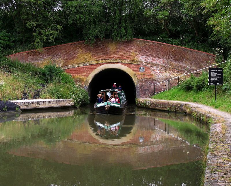
The northern portal of
Braunston Tunnel.
The Leicestershire and Northampton Union Canal was originally
planned to link the River Soar at Leicester with the River Nene at
Northampton, and from there to connect with the Grand Junction Canal. It
received its Act in 1793, but by 1797 funds had run out with
construction halted at Debdale, some 6 miles from Market Harborough.
There progress rested until, in 1805, a further Act was obtained
authorising the Canal to be extended to Market Harborough, which it
reached in 1809, some miles short of and with no prospect of ever
reaching Northamptonshire, let alone its county town. Perhaps
prompted by the project’s failure and their continuing wish to
connect to Leicester and onwards to the Trent, the Grand Junction
Canal Company had James Barnes survey a route ― as did Thomas
Telford ― to link the two canals. In fact Barnes was to undertake three
surveys, which together with Telford’s is indicative of
the difficult terrain to be crossed, for it lacks river valleys or
any other obvious routes for a canal.
A new company, the ‘Grand Union Canal Company’ ― not to be confused
with the company of that name formed in 1929 ― was promoted to
build the link, which extended from Norton on the Grand Junction
Canal, to Foxton on the Leicestershire & Northampton Union Canal.
Benjamin Bevan was appointed
Engineer, and he chose the shorter route proposed by Barnes over
that by Telford. The undulating countryside to be
crossed required cuttings, embankments and two significant tunnels,
one of 1,528 yards at Crick and another of 1,166 yards at Husbands
Bosworth, both of which were built wide enough to allow two narrow
boats to pass abreast. All the locks were built narrow (7ft)
and grouped into two flights at opposite ends of the Canal ― two staircases of five
separated by a short pound at Foxton and a staircase of four and three single locks at Watford
― linked by a 22-mile pound.
Other than the earthworks, water supply was also a problem, with the Canal depending on that gathered in reservoirs at Welford, Sulby
and Naseby, which, in effect, also provided free gratis a supply to the Grand
Junction Canal. The 1¾-mile Welford branch was built as a
navigable feeder to channel water from the reservoirs into the Canal, the
short pound between Welford Lock and the terminus being the highest
point on the present day Grand Union Canal system.
.JPG)
|
The northern extremity of the ‘old’ Grand
Union Canal at Foxton (junction with the former
Leicestershire and Northampton Union Canal), and the commencement of
the famous 10-lock double staircase. Note the narrow (7ft) lock gate. |
The extent of the celebration that accompanied the Canal’s
opening in 1814 are perhaps difficult to understand in an age
when our navigable inland waterways are
regarded in the general scheme of things as unimportant .
. . .
“On Tuesday the 9th inst. the Grand Union Canal was formally
opened by the Committee of Management, who assembled at Long Buckby
Wharf, with several of the neighbouring Gentlemen and a Deputation
from the Union Canal Committee, proceeded in a boat, decorated with
flags and accompanied by an excellent Band of Music. The interest of
the passing scene was heightened by the Boats which followed, some
laden with spectators, and others with merchandize from London. The
Inhabitants from the adjoining villages crowded to the banks, and
loudly greeted the Procession. In eight hours the whole line was
passed, and the encomiums justly bestowed on the Works must have
gratified the Engineer, (Mr. Bevan) who in three years and a half
has so happily and ably executed a Canal of 23¼ miles in length,
attended with considerable difficulties in its progress, and having
in its line two Tunnels; and several heavy Embankments. ― The
festivity of the day was concluded by a Dinner in the Town-hall at
market Harborough, at which Sir Jas. Duberly presided. ― This
Navigation completes the water-communication thro’ Leicester,
between London and the Derbyshire Canals, thereby opening new
Markets for the produce of Leicestershire, and giving a direct route
for the trade between the Metropolis and Nottinghamshire, and the
Eastern parts of Derbyshire and Yorkshire.”
The Leeds Mercury, 20th
August, 1814
Despite the jubilation that accompanied its opening, the ‘old’ Grand
Union was never a financial success due to its heavy construction
costs and reliance on traffic originating from other systems; later,
the railways were to capture most of its trade. Although the Canal and
its bridges were built wide, its locks were not due to the Grand
Junction Canal Company wishing to discourage wide boat traffic on
the lower part of its system, where its tunnels (Blisworth and
Braunston) were too narrow to permit two wide boats to pass abreast.
In 1894, the Grand Junction Canal Company bought the old Grand Union and the adjoining Leicestershire &
Northampton Union Canal, which were then on the verge of financial collapse.
The Board realised that if trade was to develop, their
Leicestershire canals needed to be improved and they commenced a programme of dredging
and ― despite the problem with tunnel width on the main line ―
alterations to permit the passage of wide boats. Other
problems to be addressed were, on the old Grand Union section, the excessive time taken to lock
through the long Watford and Foxton flights and shortage of water.
The use of inclined plane boat lifts at Foxton and Watford was an
attempt to address all three problems with a single solution ―
bypassing the narrow flights of locks using boat lifts would enable
wide boats to enter the canal
while reducing both the delay in locking and the water wasted in the process.
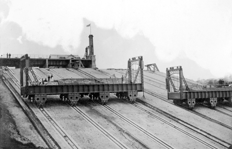
Designed by Gordon Cale Thomas, the Grand Junction’s engineer, the boat lift
installed at Foxton used two caissons, each capable of accommodating
a single wide boat or two narrowboats abreast, entry being through vertical
guillotine gates that created a watertight seal when closed. The
caissons, when filled with water, balanced each other. The lift,
which was
powered by a small stationary steam engine, took some 12
minutes to complete a lift compared with, at best, 45 minutes for
the passage of a single narrow boat through the Foxton flight. No
water from the upper pound was lost in the process, for what flowed
out in the downward caisson was returned in the upward. But
the Company was reluctant
to install a second lift to bypass the Watford flight ― that
at Foxton had cost £40,000 ― or alternatively widen the Watford locks.
This
defeated much of the scheme’s overall objective:
“If we have a cargo in Leeds for delivery to London, we will
presume that we start from Leeds with a short boat measuring 57 feet
6 inches by 14 feet beam [governed by lock dimensions] . . . . we
could journey by Wakefield, Barnsley, Doncaster, Keadby, Newark,
Nottingham, Loughborough and Leicester, as far as the flight of
seven locks at Watford on the Grand Junction Canal . . . . these
locks can only accommodate narrow boats, and form the remaining
obstacle to prevent us reaching London.”
Evidence from H.R. de Salis (Vice Chairman Fellow,
Morton & Clayton)
to the Royal Commission (1906).
The Foxton boat lift conveying two pairs of
narrow boats.
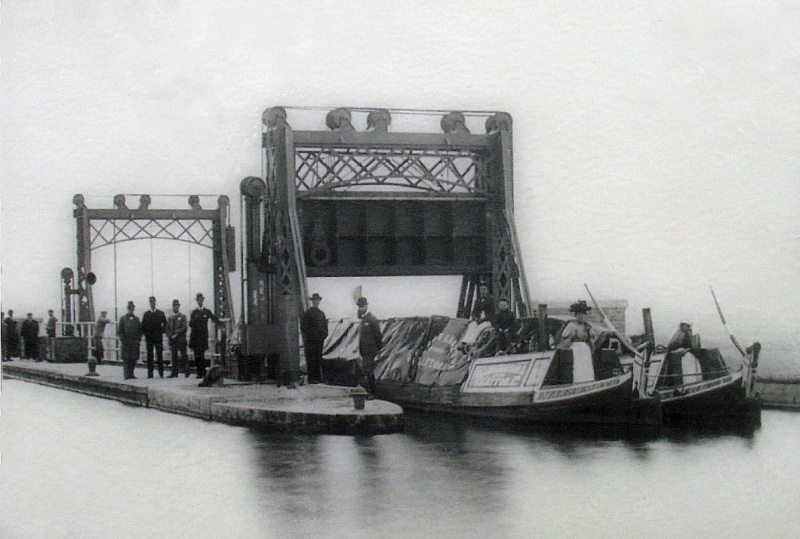
Although the Foxton boat lift achieved its purpose, in practice its rails
suffered excessively from stress due to the weight of the caissons. More important, the anticipated growth in traffic on the Leicester
section failed to materialise and the lift’s operating and
maintenance costs could not be justified on what there was.
After eleven years in service it was taken out of use and eventually sold for scrap
in 1928 for the princely sum of £250. Today, the Foxton Inclined Plane Trust
has cleared the site of foliage for visitors to see, their
ambitious long-term aim being to rebuild the lift.
Despite the Company’s efforts to promote the Leicester route, its
trade continued to diminish. During the 1930s, as part of
their canal improvement scheme, the Grand Union Canal Company
planned to rebuild the Foxton and Watford locks to accommodate wide
boats, but they the failed to secure the necessary government
grant. Following a brief revival during
WWII., regular trade had ceased by the 1950s leaving the waterway
almost derelict. But having managed to survive into the era of leisure boating, the waterway has
since gained a new lease on life.
――――♦――――
To
the south of Norton Junction, the Canal descends through the Long
Buckby flight of seven locks to reach the village of Whilton and the
15-mile Blisworth pound. Some 3½ miles to the south of Buckby bottom
lock lies . . . .
“Weedon, a village in Northamptonshire 8 miles NNW of Towcester.
It stands on the Grand Junction Canal and has a great ordnance depot
and barracks.”
The General Gazetteer,
Richard Brooks (1820)
The
”great ordnance depot and barracks” referred to is the former
Royal Ordnance Depot, [4] a relic of the
Napoleonic Wars with their threat of French invasion.
|
“Such as been the demand for small arms for the
grand expedition, that an order has been made to the
Board of Ordnance, for 22,000 muskets to be sent from
the depot at Weedon; this requisition was received on
Saturday se’nnight [the space of seven nights and
days], and the whole was packed in cases and sent off
for London on Monday morning, by canal boats. On
this occasions nearly two companies of the Bedford
Militia, stationed at Weedon, were employed on the duty.
The arms will be replaced from Birmingham. Upwards of
120 pieces of artillery are said to be at the above
depot, with ammunition wagons, forges, &c. all in
perfect working order for immediate service.” |
|
The Hereford Journal, 9 August
1809. |
The
Depot was built following an Act of Parliament of 1803, which provided for the acquisition of 53
acres of land; this was later extended to some
170 acres. The site’s location was chosen for its considerable
distance from the potential invasion shores of the South Coast
while being well connected with other parts of the country via the
Grand Junction Canal and the Turnpike (the A5). The Depot
housed armouries, storerooms, magazines, guns
and equipment. [5] Nearby were barracks and stables for the
officers, men and horses of troops of cavalry and horse artillery. Security
was tight, the Depot being surrounded by a high wall at the corners
of which were bastions built as sentry lookouts, with patrol walks
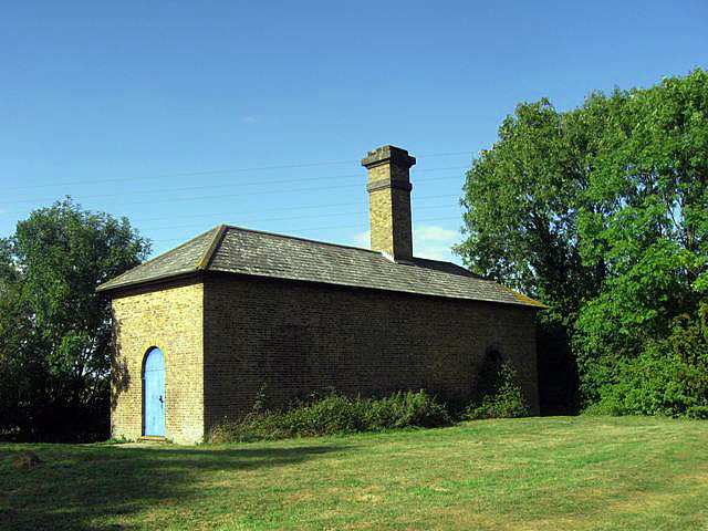
along the top. Lodges were built at each end of the main
enclosure, each equipped with a moveable portcullis.
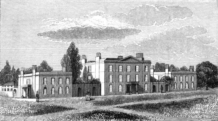
The barracks block at Weedon, as
depicted in Osborne's London & Birmingham Railway Guide
(1840)
In 1804, Barnes built a ⅝-mile branch to service the
new Depot. The military branch canal entered the Depot under a
portcullis, set in a building known as the East Lodge, which formed
part of the surrounding wall. The canal continued into the magazine, passing
through a further smaller building and portcullis. At the far end
was yet another portcullis leading to a barge turning area outside
the perimeter wall, but barges were also able to turn in a canal
basin within the magazine enclosure.
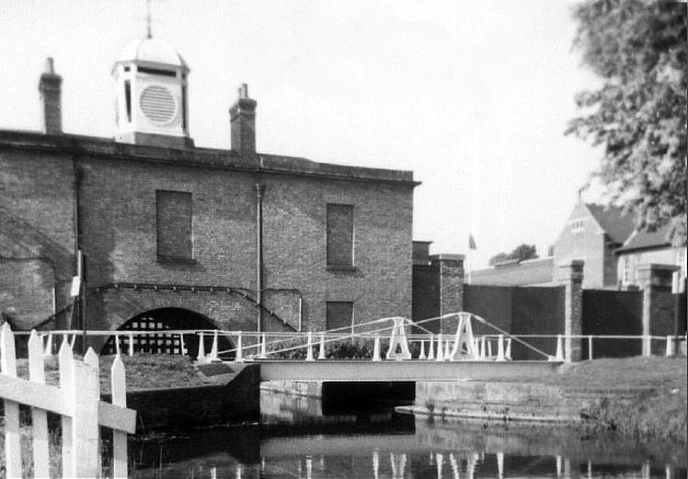
Above, the East Lodge and portcullis;
below, Barnes’s service canal.

Weedon Depot closed in 1965 and much of this interesting historic
relic has since been demolished; what remains is used by light
industry. Now isolated from the main line, Barnes’s branch canal
still runs through the middle of the site like a neglected
ornamental feature.
See also Appendix I.
――――♦――――
Gayton Junction
lies a
further 7½ miles to the south. Here, the
Northampton Arm heads east to the town where, at Northampton
Junction, it connects to the River Nene and onwards to East Anglia’s waterways and The Wash.
Construction of the Northampton Arm was delayed for many years
and in that respect shares a similar history to its contemporary, the
Aylesbury
Arm. Authorised in the 1793 Act and surveyed by Barnes
three years later,
the Company was reluctant to build this short link from Gayton to
the River Nene due mainly to the supply of water it would require from
the main line. [6] However, after much
protest by the town’s citizens, the Company was eventually persuaded, but to save expense Barnes was instructed to
build a
double-track horse tramway using sleepers and
rails released from the now redundant Blisworth tramway and the
completed Wolverton embankment:
“GRAND JUNCTION CANAL.―We
are happy to announce the completion of nearly all the great works
which are going on upon this important and extensive line of
navigation. On Monday morning last, the stupendous embankment
between Wolverton and Cosgrove, near Stony-Stratford, was opened for
the use of the trade. By this great work nine locks by its side,
four down and five up, are avoided, and one level sheet of water is
now formed, from Stoke Bruerne to some miles south of Fenny
Stratford (this overlooks the lock at Cosgrove), as well as on the Buckingham branch, extending to within
a mile of that town. The embankment seems to possess great
stability.
The branch and iron railway, that is to connect the Grand Junction
Canal with the New River at the town of Northampton, as also with
the Leicestershire and Northampton Union Canal, are proceeding
rapidly, and their completion may be expected about the end of next
month.”
The Morning Post, 30
August 1805
. . . . but as mentioned earlier, the Leicestershire and Northampton Union Canal
was never to reach Northampton.
Opened in 1805, the Northampton
tramway was operated by the firm of Pickfords, which relocated from
Blisworth wharves from where it had operated the hill tramway. But
that to Northampton proved unpopular, and in 1810, after much protest by the
town’s citizens, the Company agreed to construct a narrow
canal, although work on it did not commence for a further
three years. Built by Benjamin Bevan to
Barnes’s survey,
the 4¾ miles Northampton Branch opened on May 1st, 1815 to the usual
celebrations:
“On Monday May 1, was opened the Branch Canal between the River
Nene, at Northampton, and the Grand Junction Canal. The day being
remarkably fine, a great multitude of persons assembled to watch the
first arrival of the boats, several of which were laden with various
kinds of merchandise, manufactured goods &c. &c. from Ireland,
Liverpool, Manchester, Yorkshire, Lancashire, Cheshire, &c. &c. and
upwards of twenty with coals. From the greater facilities thus
afforded to trade, particularly in the article of coals, the
inhabitants of Northampton and neighbourhood may reasonably
anticipate considerable advantage. After mooring the boats, amidst
the firing of canon, different parties spent the remainder of the
day with the utmost conviviality.”
The Leicester Journal,
12th May, 1815
The limit of navigation was later extended to West Bridge, with
wharves being built to serve mills, timber and coal yards. Although a
steady trade was established, it never attained a sizeable volume due
mainly to the narrow locks that restricted the size of craft able to
use the branch.
――――♦――――
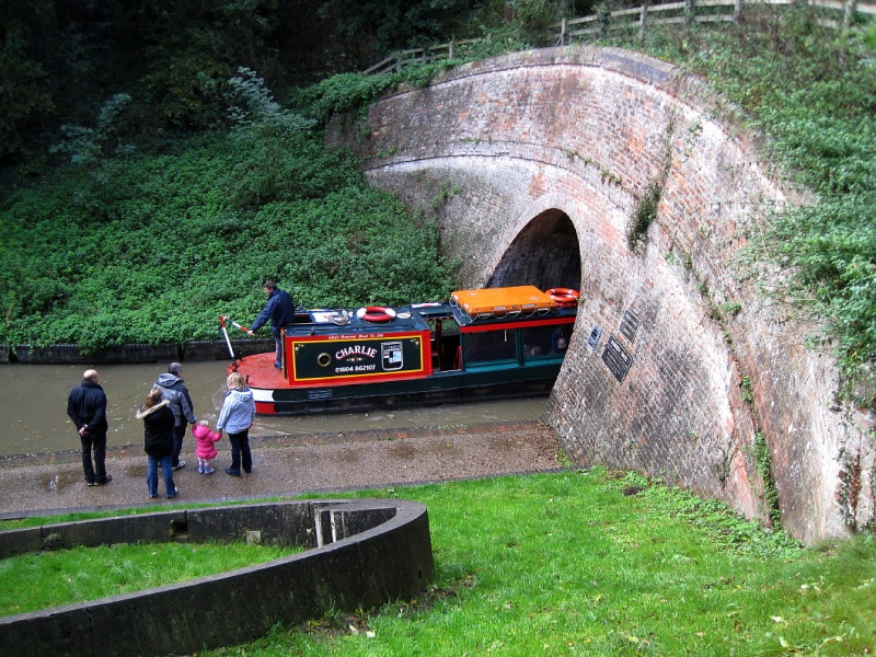
|
Southern entrance to Blisworth
Tunnel. The concrete ring (bottom left) is one of the
reinforcing liners
inserted throughout the central
third of the tunnel’s length during major repairs carried out in
1982-84. |
The village of Blisworth lies just to the south of Gayton
Junction. The canal reached Blisworth from the north in
September 1796, but it was not until the Blisworth Tunnel was opened
in 1805 that a direct link with the south was established. In
the intervening period, Blisworth Wharf, operated by Pickfords
among others, became the busiest inland port in England.
Pickfords was already an established London-based road carrier when, in 1778,
the firm began to convey goods by barge as well as by wagon.
At this time the firm’s operations were being conducted by 50
wagons, 400 horses and 28 barges, and by 1800 they had added 8 canal
depots. In 1803 their canal services reached
Birmingham, and the firm went on to establish warehouses and wharves
at London (City Road and Paddington) and at Brentford. They advertised two classes of
services:
-
‘fly boats’ travelling day and night with two steerers and two
drivers (for the horses) at 3 to 3½ mph, covering 40-miles a day
in stages, with fresh horses at each stage;
-
by barge at 25 miles per day, with two men resting at night.
An
article on canals in Rees’s Cyclopedia of 1805 praises
Pickfords fly boat services “which travel night and day, and arrive
in London with as much punctuality from the midland and some of the
most distant parts of the kingdom, as the waggons do.”
During construction of the Blisworth tunnel, the village became a
transhipment terminal for the goods being
carried road over Blisworth Hill to the Northampton to Old Stratford
turnpike. Land was taken by Messrs. Barnes (he of the Canal), Roper & Co.
and rented
to canal carriage companies, including Pickfords, on which to erect warehouses.
However, the Grand Junction Canal Company received intelligence that
their Resident Engineer was lining his pockets to
their detriment; worse still,
“. . . . that Roper and Barnes having no inconsiderable weight in the
Councils of the Directors, it is probable that the navigation may
stop at Blisworth many years, possibly for ever”. [7] And so the
Company’s Northern Committee, which included the Marquis of
Buckingham, “. . .
thought it their duty, in consequence of some complaints, to
navigate the Canal from Braunston to Blisworth, and to enquire into
the state of the Company’s concerns in that part of the line.”
Their inspection found all to be above board,
and that “. . . the part Mr. Barnes has
taken in this concern has been with the purest and best motives; and
that the Company have derived a very considerable emolument from his
exertions”. [8]
But road communication across Blisworth Hill proved
unsatisfactory, and so the pioneer rail engineer Benjamin Outram was
employed to construct a double-track, horse-drawn tramway. The
tramway was in operation by mid 1800 and remained in use until the
tunnel was opened to much celebration and the customary
dinner in 1805:
“THE GRAND JUNCTION
CANAL – That grand line of
communication, between the metropolis and the most distant parts of
the kingdom, which the Grand Junction Canal was to effect, was
incomplete till Monday last, owing to a range of high land between
Stoke Bruerne and Blisworth, in Northamptonshire, not being
penetrated by a tunnel or arch, as intended; but all goods coming
past that place, have been obliged to be unloaded, and placed on
waggons, and conveyed on a railway over the hill, to be embarked
again in other boats.
On Monday morning, the weather proving very fine, an amazingly large
concourse of people were assembled, some of them from considerable
distances, to view the stupendous works at Blisworth Tunnel, and to
see the grand procession in honour of the opening of this internal
communication by water, between the most distant places. One of the
Paddington packet-boats, called the Marquis of Buckingham, was the
first boat which went through the tunnel. The principal company
retired to the Bull Inn, at Stoney Stratford, and, about six
o’clock, 120 proprietors and friends of this grand undertaking, sat
down to an excellent dinner. Mr. Praed in the chair.”
Morning Chronicle, 30th
March, 1805
There being no further use for the railway, it was dismantled and
the materials reused in the construction of the Northampton tramway.

Horse tramway (or plateway).
――――♦――――
The
Blisworth tunnel ― 3,056 yards in length ― lies to the south of the
village and is approached at both its ends through substantial
cuttings. There is sufficient width within the tunnel for narrow
boats to pass, but not wide boats. The tunnel has no tow path;
the barge
horses were led over Blisworth Hill while the boat crews ‘legged’ through.
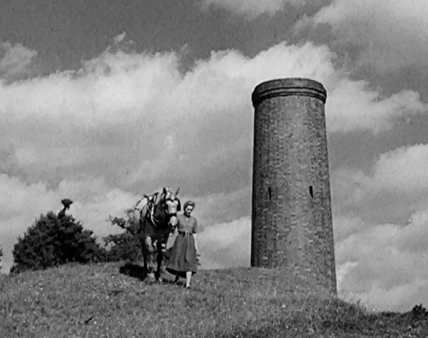 |
|
Walking the barge
horse over Blisworth Hill. On the right is a
ventilation shaft ―a former ‘pit’, built to service the tunnel while it was
being built. A number of them
were afterwards extended into the chimney-like
structures seen today. |
In the age preceding mechanical propulsion, where a tunnel did not
have a tow path one method of
propelling a boat through was by the use of human legs placed
against the tunnel roof or (in the case of the Braunston and
Blisworth tunnels) the walls. This practice, known as
‘legging’, required two people to perform. Each lay at
opposite ends of planks (‘wings’) placed across the bows of the boat.
Holding
the plank with their hands, they then walked the boat along using their feet
against the tunnel walls. Professional
leggers were available, who in the early days of the Canal sometimes
terrorised the boatmen into employing them, which led to complaints
about:
“. . . the nuisance arising from the notoriously bad characters
of the persons who frequent the neighbourhood of the Tunnels upon
the plea of assisting Boats through them.”
Grand Junction Canal Company Minute Book, 10th
November, 1825
Eventually, in 1827, the leggers were registered and employed by
the Company who issued them with brass armlets for identification. They
were paid a standard rate of 1s 6d for a single trip, Blisworth men
working south and Stoke Bruerne men north. In 1859, the novelist
Charles Dickens commissioned John Hollingshead to write a number of
travel articles to appear in the periodicals that Dickens published.
Among them is an account of a journey that Hollingshead made along
the Canal, which includes a description of legging a narrow boat
through Blisworth Tunnel (Appendix
II.).
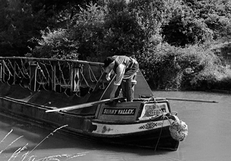
Above: fitting the wings (or legging boards).
Below: legging.

When steam tugs appeared in 1871, the professional leggers were made
redundant; this from the Company’s Minute Book:
26th April 1871: Mr Mercer reported that a tug was now at work at
the Braunston Tunnel and that the same charges were being made as at
the Blisworth Tunnel viz: Boats with cargoes of 25 tons or upwards
each, 1/6d each way. Boats with cargoes of under 25 tons, 1/3.
Empty boats 1/-. And that the services of the leggers would no
longer be required . . . Resolved that a weekly allowance of 5/-
each be made to [former leggers] Mr Benjamin, 75 years of age
and 44 years at the tunnel. R Thomas, 65 years of age and 38
years at the tunnel and John Fox 64 years and 19 years at the
tunnel.
But the new steam tugs were not universally welcome:
6th June 1871: Letter from Mr Cherry reporting that some of the
boatmen refused to avail themselves of the Tugs in use at the
Blisworth and Braunston Tunnels . . . . Resolved that all boats
using Blisworth and Braunston Tunnels between the hours of 4 am and
8 pm be hauled through the same by the Company’s tug at the
following scale of charges viz: Boats with cargoes of 25 tons or
upwards, 1/6d each way. Boats with cargoes of under 25 tons, 1/3. Empty boats 1/-. Any boatman refusing to have his boat so hauled be
charged a sum not exceeding one penny per ton for the weight on
board.
The introduction of steam propulsion was not without other problems. Ten years earlier, two fatalities had occurred:
27th September 1861: The chairman reported that on the 6th inst
an accident had occurred on board one of the Company’s steam boats
in the Blisworth Tunnel, by which two men, Webb and Edward Broadbent
had been suffocated and two men severely burnt and that every
possible attention had been given to the men injured who were now in
the Northampton Infirmary and that the sum of £45 had been given by
the Company to the widows of the deceased persons.
The need for better ventilation led to the uncovering of some of the
‘pits’ that had been sunk during the tunnel’s construction; seven of
the nineteen originally built are now used for this purpose, the
others have either been capped or filled in. A heavy build-up of
soot on the tunnel brickwork was another problem associated with
steam propulsion, which led to the introduction of a ‘brushing’
hopper. Fitted with a curved brush that matched the tunnel’s
profile, the craft was towed through the tunnel, its brush sweeping
the soot from the brickwork into the hopper.
Horse-drawn traffic continued on the Canal until well into the 20th
century, necessitating a continuing need for tugs:
“Although the old horse-drawn boats are rapidly being replaced by
motor-driven craft, the Canal Company still maintains a regular
service of tugs for the towage through the tunnel [Blisworth and
Braunston] of craft which cannot proceed under their own power. At Blisworth the Company has a warehouse of five storeys, for the
storage of goods of all kinds.”
From a Grand Union Canal Company publicity article
(1937)
The “regular service of tugs” was withdrawn in the following
year.
The
village of Stoke Bruerne lies a short distance from the southern end
of Blisworth Tunnel. When the canal reached Stoke from the south in
September 1800, this village also became a busy
transhipment terminal for canal goods conveyed over Blisworth
Hill on Outram’s horse-tramway. Today, Stoke is known for its Canal
Museum. Founded in 1963 by Charles Hadlow, an engineer, and Jack
James a boatman turned lock keeper, it was the first museum devoted
to our inland waterway heritage, although it has since been joined
by others at London (Battlebridge Basin), Gloucester and Ellesmere Port.
――――♦――――
From
Stoke the canal descends through a flight of seven locks to reach
its next level, the 5½-mile Cosgrove pound; only the lock at
Cosgrove separates it from the adjoining Fenny pound.
|
The main line descends through
Cosgrove Lock (No. 21) on the left. To the right is the remnant of
the branch to Stony-Stratford and Buckingham,
now used as moorings.
Rails set into the towing path signify that
Cosgrove
once exported sand and gravel, the
worked out pits (now flooded) being visible from Cosgrove
embankment. |
The
main line passes through Cosgrove village, following
the right bank of the Tove to near its confluence with the Great
Ouse. A public wharf was established about half a mile north
of Cosgrove, where the road to Castlethorpe crossed the canal.
This is Castlethorpe Wharf (a.k.a Thrupp Wharf), and it hosts a
public house, the Navigation Inn. When the Inn was put up for
sale in 1876, the wharf was described thus:
“The excellent WHARF-YARD, with landing for tying-up eight boats;
coal and coke yards, lime-kiln, capital warehouse (capable of
storing 150 quarters of corn), salt-house, granaries,
weighing-house, with weighing machine; stabling for eleven horses,
lock-up coach-house, large barn, with slated roof; piggeries,
excellent walled kitchen garden, and other appurtenances thereto
belonging. There is a COTTAGE, containing three rooms,
Adjoining, which is now used as a warehouse. And also all the CLOSE
of first rate Arable LAND, containing 9¾ Acres, or thereabouts,
adjoining the before mentioned Property, and fronting the road
aforesaid; together with A CLOSE of excellent Pasture LAND,
containing 11½ Acres, or thereabouts, adjacent thereto, with good
thatched hovel, and appurtenances created thereon, the whole being
now in the occupation of the said John Ayres.”
Cosgrove lock (No. 21) lies at the junction with the former Stony
Stratford and Buckingham
Arm. Authorised in the Grand Junction Canal Act of 1793 and
originally planned as a short branch to Old Stratford and the busy
highway of Watling Street (the A5), the Arm was soon extended a further 9¼-miles to Buckingham,
[9] principally at the instigation of
the Marquis of Buckingham who loaned the Company the construction
cost:
“The branch of the Canal from Buckingham to the Grand Junction
Canal was opened this day with great rejoicings. A barge with the
Marquis of Buckingham, Mr. Praed, and Mr. Selby (Gentlemen of the
Committee) and Mr. Box, the Treasurer, accompanied by a large party
of Ladies and Gentlemen, and a band of music, led the way to the
procession of 12 barges, laden with coal, slate, and a variety of
merchandise. Upon their entrance to the basin at Buckingham they
were saluted by the firing of several cannon. A numerous party were
handsomely entertained by the Marquis of Bath at the ‘Cobham Arms
Inn’ on this occasion, and a liberal supply of beer was given to the
populace. This branch of the Canal, 9¼ miles in length, has been
completed in about eight months, and will secure to an extensive
distance of country most substantial benefit.”
The Gentleman’s Magazine,
1st May 1801
As elsewhere, water-borne transport was to have a
considerable impact on the town and its locality. Coal, stone,
bricks, manufactured goods, imported produce from London Docks were
all more readily available at much lower cost than ever before; and
local produce could be moved faster and more easily, whether it was
foodstuffs to the local market, or loads of hay and straw
destined to nourish and sustain the motive power of the Metropolis. Within a few years, trade on the branch had
reached 20,000 tons per annum and was to remain at this level for
almost fifty years.
The first section of the Arm to Stratford was, in common with the
main line, built as a wide canal, but the extension to Buckingham
was built narrow. Its route led over easy ground, only two locks
being required, so construction progressed quickly. In its early
days the Arm was successful, but from the 1850s
railway competition led to its decline, which was further aggravated
by leakage and by Buckingham Corporation using it as a dump
for the town’s sewage, which caused silting. By 1904, Bradshaw’s Guide was
describing its upper section as being “barely navigable” and
by the 1930s the Arm was derelict. All that now remains is a section
of about 100 yards, which extends westwards above Cosgrove lock and
is used for moorings. The remainder of the canal has been filled in,
although there is an ambitious restoration scheme, the Patron of
which is the present Speaker of the House of Commons.

|
A relic of the Canal’s horse
drawn days, the Cosgrove horse tunnel
enabled barge horses to
be led under the Canal to the stables. |
――――♦――――
Immediately to the south of Cosgrove lock, the Canal crosses the
valley of the Great Ouse on a substantial mile-long embankment:
“All the works of that extensive and complicated undertaking, the
Grand Junction Canal, are now completed. The stupendous
embankment that had been raised between the villages of Wolverton
and Cosgrove, near the market town of Stony Stratford, has been
lately opened for the use of trade and internal navigation. . . .
The arches erected under this embankment, to create a passage for
the river Ouse, which arches were believed and reported to be in a
sinking state soon after the central arches were struck, are at
present considered as sufficiently firm, and the embankment is
thought to possess all imaginable strength and durability.”
The Universal Magazine of Knowledge and Pleasure,
July-Dec, 1805
Reference to the “arches were believed and reported to be in a
sinking state” refers to the three arches of a brick-built
aqueduct, designed by Jessop, which carried the embankment
over the Great Ouse. When the timber shoring was removed the
aqueduct began to show signs of failure . . . .
“After its erection Mr. Bevan, the engineer, of Leighton Buzzard,
being called upon, gave it as his opinion, it would not stand twelve
months; his prediction was verified, for in less than six months
after its construction, the materials were so indifferent, that a
continued leak of the aqueduct was observable.”
A Tour of the Grand Junction Canal in 1819,
John Hassell (1819)
The embankment had experienced slippage in 1806, shortly after its
opening. This was repaired, to be followed in February 1808 by
failure of the aqueduct:
“On Friday morning last the inhabitants of this town were thrown
into the utmost consternation, by information which arrived from
Wolverton, that the large embankment for carrying the new line of
the Grand Junction Canal across our valley, about a mile below this
town, had fallen in; and that the river Ouse was so dammed up
thereby, that this town must shortly be intirely inundated to a
great depth. I hastened to the spot, where my fears were very much
allayed, by finding that one of these arches, which had been propped
up underneath with timber, soon after the centres were removed, was
still standing; and that this one arch, owing to there being no
flood in the river, was able to carry off the water of the river as
fast as it came down. On examining the other two arches, I found
that about 22 yards in length of the middle part of each had fallen
in, and blocked up the arches, laying the canal above in complete
ruins, emptying it as far as the nearest stop-gate on each side, and
exposing the remains of 500 quarters of coke and cinders which the
contractors had lain in the arches. The ends of each of the broken
arches were found standing in a crippled state. Most fortunately for
the Public, as well as the Company, the old line of the canal and
locks across the valley are still remaining, and in sufficient
repair, immediately to convey the barges, and prevent interruption
to trade: but the loss of £400 per month, which I am told has of
late been the amount of extra tonnage received by the Company for
goods passing over this embankment, will be lost to them during the
period of re-building the arches and repairing the canal over them.”
Jackson’s Oxford Journal,
27th February, 1808
A subsequent investigation attributed the aqueduct’s failure, not to
deficiency in Jessop’s design, but to poor workmanship on the part
of the contractor. The legal dispute with the contractor that
followed was settled in the Company’s favour, with damages being
awarded for loss of trade and the cost of the replacement. Today,
the Great Ouse is bridged by Benjamin Bevan’s iron trunk aqueduct of
1811:
“The new aqueduct bridge of the Grand Junction Canal, over the
Ouse River, below the town of Stoney Stratford at Wolverton, which
has been for some time in preparation, of cast iron, in lieu of that
of brick, which fell down in 1808, was on 22nd January, at one
o’clock, opened for the passage of boats, the Empress,
belonging to Mr. Pickford, and his Queen Charlotte, being the
first of 30 which passed this first metal aqueduct that has been
constructed anywhere in the South of England. ― The whole length of
the iron-work is 101 feet; it is wide enough for two boats to pass
each other, and has a towing path of iron attached to it; it is firm
and tight in every part. Mr. Benjamin Bevan, the Engineer who
designed it, and about twenty persons only besides the boatmen were
present, no announcement having been made of its completion. The
opening of this Aqueduct and the passage of trade over the
embankment, will, it is expected, add full £500 per month to the
revenues of the Company.”
The Tradesman Vol. VI.,
Jan - June, 1811


Benjamin Bevan’s cast iron
trunk aqueduct of 1811.
――――♦――――
The
Canal now enters Wolverton, the first town of any size on its
southward journey. Wolverton was once home to the London and
Birmingham Railway Company’s locomotive works before this was transferred to
Crewe, after which Wolverton Works concentrated on the manufacture
and repair of rolling stock. At Wolverton, the Canal passes
under the former London and Birmingham Railway ― which Robert
Stephenson conveyed across the Ouse Valley on a fine brick-built viaduct
(1838) ― before crossing Grafton
Street on the New Bradwell aqueduct (1991). It then commences a
circuitous journey around the eastern outskirts of Milton Keynes,
during which it becomes a travelling companion to the River Ouzel [10] until their paths
eventually diverge at Grove Lock, to the south of Linslade.


Stony Stratford lies to the south-west of the canal at Wolverton.
Here, at
‘Watling Works’, the engineering firm of Edward Hayes was once
located. Although originally in the agricultural engineering business,
the firm was to make its mark in boat-building, not canal boats, but
steam boats of various descriptions for
coastal and harbour work ― and this despite being some distance from
the Canal and many miles from the sea:
“In 1845 the late Mr. Edward Hayes started the works for general
engineering, but gradually the business has become confined to the
building of steam yachts, tugs and launches. These are exported to
all parts of the world for steamers and machinery of various
descriptions have been built for the British Admiralty, Crown Agents
for the Colonies, the Board of Works, Trinity House Pilots, the Shah
of Persia, the Sultan of Morocco, besides various foreign
governments and well-known shipping lines. During the late
South African War a little steamer destined to work in connexion
with the landing of troops and stores actually steamed from the
place she was launched, the Old Stratford Wharf, which is a branch
of the Watling Works, along the Grand Junction Canal to the Thames
and thence to Delagoa Bay, South Africa.
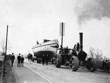
In Stony Stratford it is not an unusual sight to see one of these
steamers being drawn on large eight-wheel trolleys by a powerful
traction engine from the Watling Works, where they are built, to
the wharf half a mile away, and often followed by its engine and
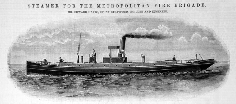
boiler on separate trolleys . . . . The steamers originally built
for the riverside work of the Metropolitan Fire Brigade came from
the Watling Works, and the present Mr. Edward Hayes has taken out
numerous patents for improving steamers, one of the most recent
being for cheapening and facilitating the exportation of small
steamers abroad, making it possible to erect steamers at the site of
their work and where only unskilled native labour can be obtained.”
The Victoria History of Buckinghamshire
(1908)
The steamer that sailed to South Africa was the 65ft Curlew.
Built
in 1902 and launched into the Canal, she then set off for London, grounding on a
shoal at Leighton Buzzard en route from which she was hauled by
a team of horses. Having reached the Port of London under her own
steam and successfully completed her trials, she then sailed on to
her overseas customer. The larger of Hayes’s vessels built for
export were prefabricated.
The firm ceased boat-building in 1923 due to the glut of small
war-surplus vessels on the market, but at least one of their craft
survives. Following her retirement from the Thames Water Conservancy
Board, the river tug Wey (originally named Pat) was repatriated and
is now on display at Milton Key Museum.
――――♦――――
|
 |
|
Newport Pagnell
Canal: charges authorised under its Act |
At
Great Linford the canal approaches the M1 (north of junction 14) and
the site of the junction with the former short ― and
short-lived ― Newport Pagnell Canal (1¼-miles). As with the Aylesbury and
Northampton arms, the Grand Junction Canal Company were unenthusiastic about building
this branch,
the view being that as Newport lay close to the
main line there was nothing to justify a branch. But the citizens of
the town disagreed. In 1813, after some years of fruitless argument,
they decided to promote the branch themselves while harbouring the
grander ambition of extending it eventually to Olney, Bedford and
beyond. Benjamin Bevan surveyed the line, an Act was obtained in
1814, work commenced in 1815, and the canal, built as a broad canal,
opened early in 1817.
During its comparatively short life the Newport Pagnell Canal
remained in the ownership of its promoters, and while their grander
ambitions were unfulfilled, the Canal did pay a modest dividend
throughout most of its life. In 1864 the Canal was bought by the
Newport Pagnell Railway Company who used part of it for their track bed. [11]
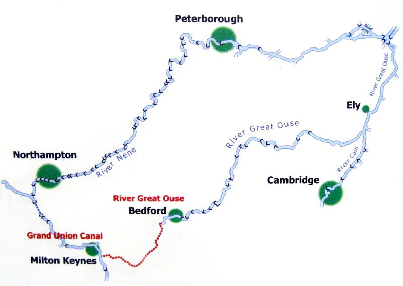
Proposed canal linking
the Great Ouse at Bedford with the Grand Union Canal at Milton
Keynes.
Bedford and
Milton Keynes Waterway Trust.
――――♦――――
Fenny pound extends for 11½-miles from Cosgrove lock southwards to
Fenny Stratford. Located just to the east of Watling Street (the
A5), Fenny Stratford lock provides the unusually small rise of 12 inches, for it was never intended to form a permanent
feature of the canal. Its purpose was, as a temporary measure, to
control leakage through the uppermost part of the canal banks in
Fenny pound by reducing the water level. The problem
was addressed in 1802, but although the Company considered removing the
lock on more than one occasion, they were deterred by the cost and
disruption to canal traffic, and the ‘temporary’ lock lives on.
The Canal was opened to Fenny Stratford in 1800, the event attracting
public celebration and ending with the customary dinner for the Company
hierarchy:
“The Grand Junction Canal was on Wednesday opened for barges from
the Thames at Brentford, to Fenny Stratford, and early in the
morning a number of boats started from Tring, at which place the
canal has been completed these two years past; about one o’clock
they passed through Leighton; and a short distance before they
reached Fenny Stratford the Marquis of Buckingham, accompanied by a
number of friends and principal proprietors, attended by the band
and a party of the Buckinghamshire Militia, met them. They then went
in grand procession to Fenny Stratford, where they were received
with firing of cannon belonging to the town, and other
demonstrations of joy. The Marquis and the proprietors retired to
the Bell Inn to dinner.”
Jacksons Oxford Journal,
31st May, 1800
By the 1930s, regular local trade on the Canal appears to have
mostly died out on the section of the Canal north of Berkhamsted,
with Grand Union Canal Company publicity material of the period
identifying very few of the wharves with tenants. Of those that
are listed, most are located along the section from Fenny Stratford
to the Leighton area:
|
 |
|
Grand Union Canal Company
route map, c.1938. |
“At this point thousands of tons of
Leighton sand are loaded from the adjoining pits . . . and taken by
canal boat both to Paddington and Brentford for distribution to all
parts of London. Mr L. B. Faulkner, one of the long distance canal
carriers, has his depot and boat repairing yard at Leighton Buzzard.
. . . At Fenny Stratford, quantities of farina
[12]
and sugar are landed from steamers in the River Thames.”
Grand Union Canal Company
publicity material,
c. 1938
The farina and sugar referred to was probably destined for Valentin, Ord
and Nagle, a tenant listed at Fenny Stratford wharf who manufactured brewing sugars from grain brought in by
narrow boat.
Before the Canal reached Leighton, the deposits of sand in the
locality had been used by building firms and in tile-making,
but the Canal’s arrival opened up a much
wider market. Local hauliers transported the sand from quarries
for loading into barges at canal-side wharves, from where it was
shipped to London and to the Midlands. But the constant
passage of carts through the town caused such damage to the roads
that the Council demanded that the sand firms set up an alternative
form of transport. This led, in 1919, to the building of the
2ft gauge Leighton Buzzard Light Railway. Constructed from war surplus
materials and equipment, the railway became the main means of moving
sand from the quarries in the north of the town to its southern
outskirts where the grading and washing sheds were situated and from
where there was good access to the Canal and the mainline railway. But transport by canal and rail declined in the years following the
Second World War, for road haulage could deliver faster and more
directly. From the 1950s onward, Leighton Buzzard became home to
many road haulage firms specialising in the transport of building aggregates,
while the light railway has become a popular attraction for tourists
and those with an interest in the industrial narrow gauge.

Brantom’s Dock (with
towing path bridge) in
operation ― and following its transformation into an office
block.

Linslade hosted a number of wharves. Sandhole Bridge had
wharves that served the sand quarries of Heath & Reach.
Whichello’s Wharf, named after Stephen Henry Whichello and Son, coal
merchants, was situated to the north of the busy Leighton Road bridge
and on the west bank of the canal. To the south of the bridge, on
the opposite bank, was the dock of Grant and Lawson, later known as Brantom’s
Dock.
Both served as
coal yards, timber yards, agricultural machinery suppliers, brick
and tile manufacturers, etc., and they undoubtedly attracted industry
and commerce to this new part of the town. [13] Both wharves had rectangular basins perpendicular to the canal for
loading and discharging, with various warehouses, offices and other
buildings set around. In 1974 the basin serving Brantom’s
Wharf ― by then choked with weeds and mud ― was filled in to make a
car park, but its attractive towing path bridge was preserved
through the efforts of the Leighton Buzzard Preservation Society.
Traces of another of the canal-side wharfs, Garside’s Wharf, also
exists complete with its semi-inset 2ft-guage railway track. This
line was not part of the Leighton Buzzard Light Railway, but served Grovebury Quarry and connected with other tracks serving quarries
and works in the area to the south of the Linslade to Dunstable
railway branch, and east of the Canal. It appears to have been
horse-operated at first but later used locomotives. The last
boatload of sand was shipped from the wharf in 1965.
――――♦――――

The three locks at Soulbury.
One of the ‘northern engines’ pumping stations is on the right.
At Fenny Stratford the
Canal begins its gradual ascent to Tring summit, and over the next 16½ miles ― much of it in company with the River
Ouzel ― it negotiates a further 14 locks [14] rising
by 105ft. Within this section there is an attractive flight of three
locks at Soulbury together with an old steam pumping house, one of
what became known as “The Northern Engines”.
Ensuring an adequate depth of water was always at the forefront of
the canal builder’s mind, particularly at summits where recourse to
steam pumping from reservoirs was often necessary. Even then,
prolonged drought could bring traffic to a near
standstill, and there are records of the cost of pumping coupled
with the
decline of traffic due to low water making a substantial dent in the
Company’s profits (referred to in
Chapter XIV). In 1838, to help alleviate this problem, the Company awarded a contract to Grissell and Peto to build nine
engine houses and culverts between Fenny Stratford and Marsworth,
the aim being to pump lockage water back up the canal from the
valley of the Ouzel to the Tring reservoirs. By 1841 the
engines were in operation and capable of pumping water around seventeen
locks. The Soulbury pumping station ― to the right in the
picture above ― is one example, that at Seabrook [15]
another and particularly attractive in having been fortunate to
retain its yellow
brick chimney.
|
 |
|
Seabrook pumping
station |
――――♦――――
At Marsworth Junction, the Aylesbury Arm branches off to the west.
Construction of this narrow canal was authorised by the 1794 Act (together with its
contemporary, the Northampton Arm), but the Company was reluctant to
build it due in part to their concern about the quantity of water
that it would draw from the main line.
Henry Provis was appointed
Engineer, construction commenced in 1813 and the
branch was opened in either 1814 or 1815 ― oddly, there seems to be
no reliable record of exactly when. In its 6¼-mile journey, the Arm follows a
fairly
straight path across the Vale of Aylesbury, descending 95ft through
16 locks (the first two at Marsworth being a ‘staircase’ [16])
to its terminus to the south of Aylesbury town centre.
Initially the Arm was very busy, being used to transport grain,
timber, coal and building materials, but competition from the
Cheddington to Aylesbury railway, which opened in 1839, followed later in
the century by the arrival at Aylesbury of the Metropolitan Railway, led to
its decline. By the Second World War trade had become
spasmodic and the last regular delivery of coal to Aylesbury by
canal was in
1964. In the 1960s British Waterways considered the Arm for
closure, but its fortunes revived with the growth
of leisure cruising. Aylesbury Basin now hosts a marina and
is currently at the heart of a major town-centre redevelopment
programme. The Arm is also very popular with fishermen.
A more detailed account of the
AYLESBURY
ARM.
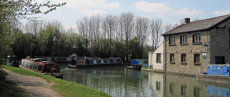
Turning into the Aylesbury Arm
at Marsworth Junction (looking south). Marsworth Wharf is on the right.
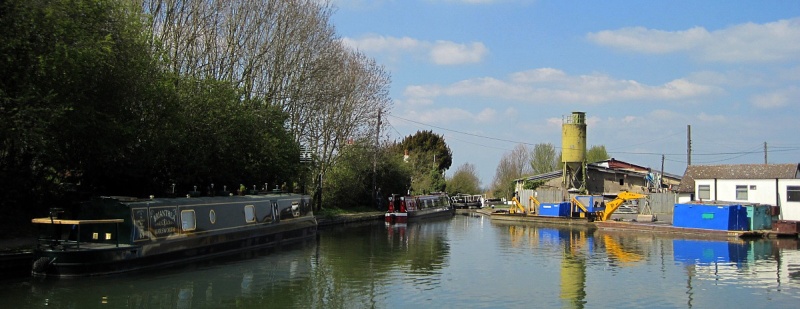
|
Marsworth Junction and the
entrance to the Aylesbury Arm.
The silo on the right
marks the site of the former British Waterways plant for manufacturing
concrete piles used for bank protection.
The wharf site has now been cleared and
is awaiting redevelopment. |
――――♦――――
APPENDIX I.
WEEDON ORDNANCE DEPOT
from
The History of Northampton and its Vicinity,
(Pub. James Birdsall, 1831)
WEEDON or Weedon Beck,
formerly called Church Weedon, but now generally Weedon Royal, from
the barracks and depot erected there; it is bounded by Nether
Heyford on the east, Dodford on the north, Everdon on the west, and
Stow with Farthingstone on the south.
The works of this depot commenced about the year 1805, and consist
of barracks originally intended for two troops of horse artillery
but now capable of containing 500 infantry; they are strong
buildings of brick erected in the form of a square; near them is a
handsome hospital. Upon an eminence contiguous to the barracks is a
most elegants edifice, consisting of a centre with corresponding
wings, built of white brick intended as a residence for the officers
of the ordnance department; which is said to have cost £18,000 in
erecting.
There are eight store-houses, four being built on each side of the
arm ot the Grand Junction Canal, which runs by this place, and a
proportionate number of work shops for the artificers. The upper
rooms of these store-houses are capable of containing 240,000 stand
of small arms, which are placed under the charge of a store keeper.
The lower rooms are appropriated for field artillery, and may be
generally computed as containing about twenty four brigades, of six
guns each, with all necessary stores, ready for service at the
shortest notice; these are under the superintendency of a field
train commissary. At an extremity of the canal branch, in an
enclosed square, completely detached from the other buildings, are
four powder magazines, one of which contains nearly 70,000 rounds of
ammunition for the field pieces; the remaining three are adapted for
powder and small arms ammunition, containing, when filled, about
5,000 barrels each. Alternately is a magazine and traverse, of equal
altitude filled with earth for the purpose of preventing extended
damage in case of explosion.
Weedon has been considerably enlarged and improved within these few
years, and now contains several neat dwelling houses some of them
being residences for officers &c attached to the depot. The quantity
of ground purchased by government for this establishment is about
170 acres.
OSBORNE'S GUIDE TO THE
LONDON & BIRMINGHAM RAILWAY
(1840)
The Royal Military Depot stands on a slight eminence, and consists
of a centre and two detached wings, with lawn in front; these form
the residence of the governor and officers, while for the common men
there are barracks on the top of the hill, capable of containing
500. At the bottom of the lawn there are eight store houses
and four magazines, adequate to contain 240,000 stand of small arms,
with a proportionate quantity of artillery and ammunition; there are
also a number of workshops for the military mechanics and a hospital
capable of accommodating 40 patients. In consequence of the
establishment of the railways, this one military force is rendered
so efficient and such power is afforded of presenting itself when
ordered by the civil authorities, in any portion of England, in the
course of a few hours, that the inutility of a number of these
expensive establishments will doubtless soon begin to attract public
attention. A troop of a few hundred men can be forwarded by
railway from this central depot to any important part of the kingdom
where their services might be required with a magical celerity and
precision that would be quite adequate to prevent mischief. A
small force permanently stationed here for such emergencies would
certainly be much more efficient than our present very numerous but
straggling military establishments, to concentrate the forces from
which, without marching to the scene of action, would often take a
much longer time than is needed in having a troop from Weedon to any
of the important districts.
――――♦――――
APPENDIX II.
ODD JOURNEYS IN AND OUT OF LONDON
by
JOHN HOLLINGSHEAD
(1860)
A journey through Blisworth Tunnel
The boatmen were preparing for the passage of the Blisworth tunnel
(nearly two miles in length), an underground journey of an hour’s
duration. The horses were unhooked, and while standing in a group
upon the towing-path, one of the child drivers, a girl about six
years of age, got in between them with a whip, driving them, like a
young Amazon, right and left; utterly disregarding the frantic yells
of a dozen boatmen, and nearly half a dozen family-boatmen’s wives. At the mouth of the tunnel were a number of leggers, waiting to be
employed; their charge being one shilling to leg the boat through. We engaged one of these labourers for our boat to divide the duty
with one of our boatmen; while the youth went overland with the
horse. A lantern was put at the head of the boat; the narrow boards,
like tailors’ sleeve-boards, were hooked on like projecting oars
near the head; the two legging men took their places upon these
slender platforms, lying upon their backs; and, with their feet
placed horizontally against the wall, they proceeded to shove us
with measured tread through the long, dark tunnel.
The place felt delightfully cool, going in out of the full glare of
a fierce noon-day sun; and this effect was increased by the dripping
of water from the roof; and the noise caused by springs which broke
in at various parts of the tunnel. The cooking on board the boats
went on as usual, and our space being confined, and our air limited,
we were regaled with several flavours springing from meat, amongst
which the smell of hashed mutton certainly predominated. To beguile
the tedium of the slow, dark journey— to amuse the leggers, whose
work is fearfully hard, and acts upon the breath after the first
quarter of a mile, and above all to avail themselves of the
atmospheric effects of the tunnel, the boatmen at the tillers nearly
all sing, and our vocalist was the captain’s straw-haired son.
If any observer will take the trouble to examine the character of
the songs that obtain the greatest popularity amongst men and women
engaged in heavy and laborious employments, he will find that the
ruling favourite is the plaintive ballad. Comic songs are hardly
known. The main secret of the wide popularity of the ballad lies in
the fact, that it generally contains a story, and is written in a
measure that fits easily into a slow, drawling, breathtaking tune
which all the lower orders know; and which, as far as I can find,
has never been written or printed upon paper; but has been handed
down from father or mother to son and daughter, from generation to
generation, from the remotest times. The plots of these ballad
stories are generally based upon the passion of love; love of the
most hopeless and melancholy kind; and the suicide of the heroine,
by drowning in a river, is a poetical occurrence as common as
jealousy.
There may have been a dozen of these ballads chanted in the
Blisworth tunnel at the same time; the wail of our straw-haired
singer rising above the rest. They came upon our ears, mixed with
the splashing of water, in drowsy cadences, and at long intervals,
like the moaning of a maniac chained to a wall. The effect upon the
mind was, in this dark passage, to create a wholesome belief in the
existence of large masses of misery, and the utter nothingness of
the things of the upper world.
We were apprised of the approach of another barge, by the strange
figure of a boatman, who stood at the head with a light. It was
necessary to leave off legging, for the boats to pass each other,
and the leggers waited until the last moment when a concussion
seemed inevitable, and then sprang instantaneously, with singular
dexterity, on to the sides of their boats, pulling their narrow
platforms up immediately after them. The action of the light in
front of our boat produced a very fantastic shadow of our recumbent
boatman-legger upon the side wall of the tunnel. As his two legs
stuck out horizontally from the edge of the legging-board, treading,
one over the other, against the wall, they threw a shadow of two
arms, which seemed to be held by a thin old man — another shadow of
the same substance — bent nearly double at the stomach, who worked
them over and over, as if turning two great mangle-handles with both
hands at the same time. |