|
 |
|
The Bridgewater Monument. |
Slightly to the east of Aldbury lies the Ashridge Estate, once
the seat of the Duke of Bridgewater. In 1803, the Tring vestry
minutes record the Duke’s passing. His Grace’s fortune having
being spent constructing the Bridgewater Canal, the family seat,
Ashridge House ― according to the vestry minutes ― fell into
“decay to such an extent that in places the roof had become open to
the sky”. The entry goes on to record that at the time of
his death, the Duke’s canal revenues had made him a very wealthy man
and that he intended to rebuild Ashridge House on a very grand
scale, had death not intervened. Ashridge House, as it stands
today, was built between 1808 and 1825 by the architect James Wyatt.
In 1832, the ‘father of inland navigation’ was commemorated with the
erection of the nearby Bridgewater Monument, a 108ft tower built
overlooking the Grand Junction Canal.
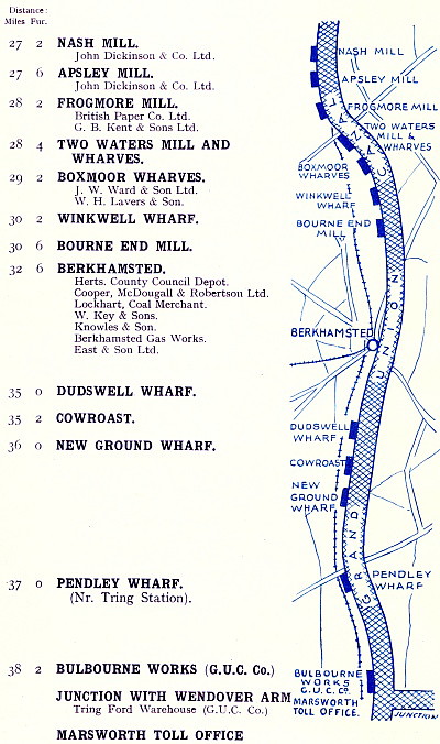
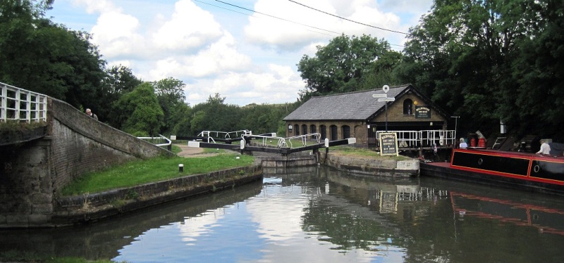
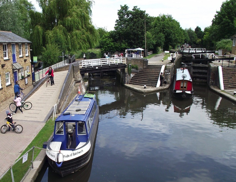
The Tring summit ends at Cowroast lock, the odd name of which is
believed to be a corruption of ‘Cow Rest’, a relic from the days
when herds of cattle were driven through the Tring Gap to market in London. John Hassell observed that the spot was:
“. . . most erroneously named . . . Here we saw herds of cows
grazing, and observed a fresh drove of sucklers with their calves
coming up to remain for the night, and we found, upon enquiry, that
this inn [The Cowroast Inn] was one of the regular stations
for the drovers halting their cattle for refreshment; hence I should
suppose, the proper name is the Cow Rest, or resting place of those
animals, for along the road, and all the way through the breeding
and grazing parts of Bucks, Bedfordshire, and Northamptonshire,
there is a perpetual supply of cows passing to the capital . . .”
A Tour of the Grand Junction Canal in 1819,
John Hassell
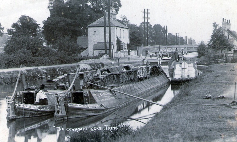
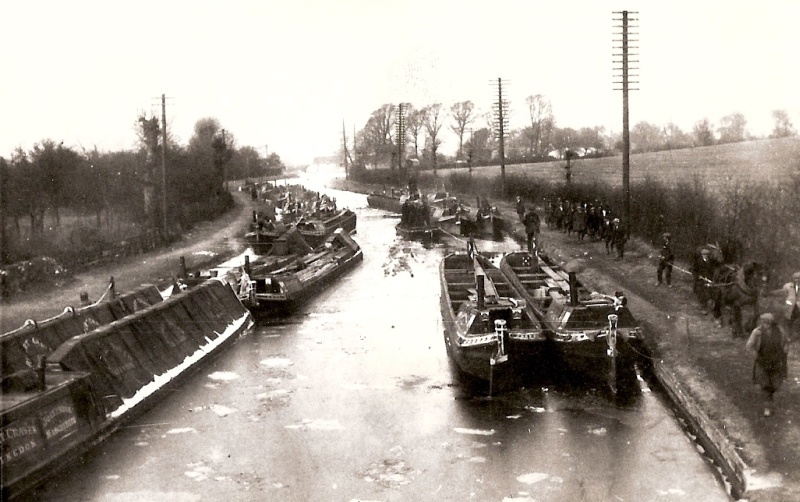
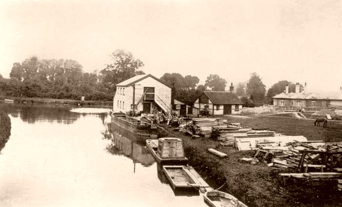
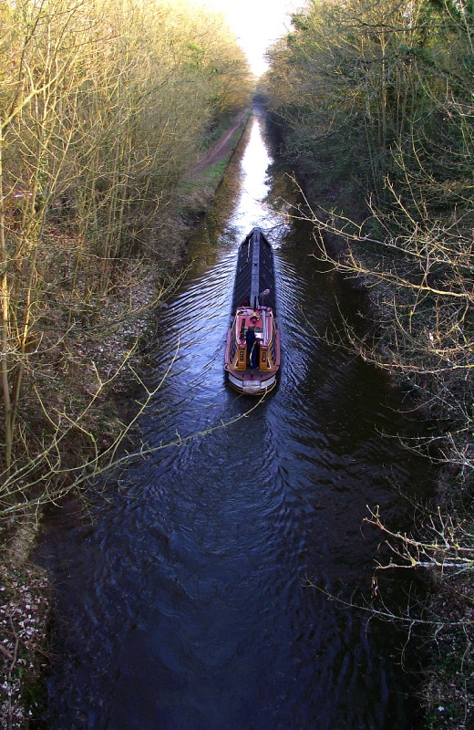
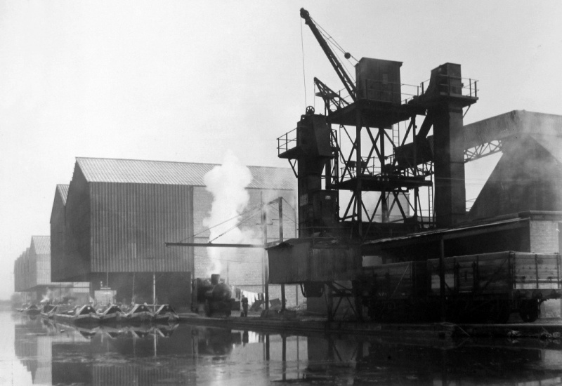
A pair of L. B. Faulkner narrow
boats, southbound at Cow Roast lock. The nearer is carrying
coal.
The telegraph poles make a nice contrast with this earlier era of
human innovation.
――――♦――――
South of Cowroast, the Canal continues to follow the original course of the
Bulbourne, then, at Hemel Hempstead, of the Gade, of which the
Bulbourne forms a tributary. Both rivers powered numerous
water mills. When the Canal was built the Bulbourne and the
Gade were diverted into
it, with excess water being returned to the original river
beds across overflow weirs set into the canal bank. During its
early years, this extraction of
water for the Canal was to bring the Company into conflict with the water millers, particularly with the paper manufacturer
John Dickinson.
|
“John Dickinson thought it would be interesting to
become an astronomer, and built an observatory at
Abbot’s Hill in which he had a fine telescope set up.
When it was ready he entered it by himself to observe
the moon. He twisted the instrument about and aimed all
over the sky, but could see nothing. Swearing loudly, he
left the observatory and never entered it again. He had
in fact omitted to take the cap off the telescope.”
The Endless Web, Dame Joan Evans, 1955
|
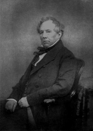
John Dickinson
(1782-1869),
inventor,
paper manufacturer and
Fellow of the Royal Society |
|
 |
Heavy traffic on the Canal resulted in more lockage water flowing down
it than had been anticipated, leaving insufficient to return to the
rivers for the use of Dickinson’s paper mills at Apsley; and, to
exacerbate the problem, that section of the Canal also wasted water through leakage. Dickinson’s complaint was not merely
about insufficient water
to power the mill wheel, but insufficient water to support the
pulping process. The 1793 Act required Company to build a
reservoir to compensate the water millers on these rivers for any
loss of water to the Canal ― expressed in the legal English of its
time, the gist of the relevant section reads:
“That before Brooks, Streams, Rivulets, Waters, Water-Courses, or
Springs, which now supply the Rivers or Streams of Gade, or Colne,
or the Berkhempstead River called Bulborne . . . . shall be taken or
used, for the Use or Supply of the said intended Canal . . . . be
diminished by Means thereof, the said Commissioners shall, and are
hereby authorized and required, to set out some Place or Places, as
near to the Line of the said intended Canal . . . . as they shall
judge most proper and convenient, a Piece or Pieces of Land, for the
making and forming a Reservoir or Reservoirs, for collecting
Flood-Waters sufficient to supply such Rivers, Streams, and Cuts,
with a Quantity of Water, equal at least to what shall be taken . .
. . for the Use or Supply of the said intended Canal . . . .”
Grand Junction Canal Act, 1793 (pp31-32)
― in other words the Company had by some means to put back, for the
use of the millers, the water it took out. But the reservoir
was not built and the long-running litigation that resulted led not
only to Dickinson being awarded damages, but the Company being
obliged to re-route the
Canal at Apsley to reduce the leakage. [6]
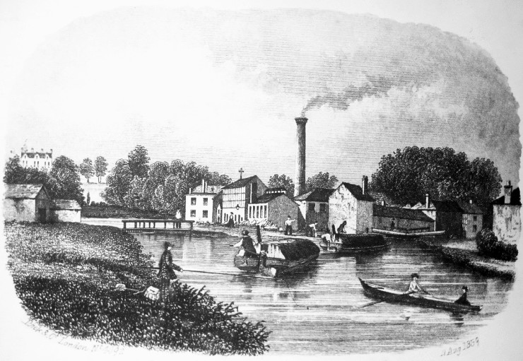
An artist’s impression of Nash
Mills, dated 1859.
As originally built, the Canal at this point followed a separate
course to the Gade, from above Apsley Mills to below Nash Mills,
where it rejoined the river after passing through a series of locks;
the deviation changed the course of the Canal to that of the river.
This required a further Act, which received the royal assent on 17th
March 1818, and the deviation opened that year:
“Dickinson had contracted to carry out the brickwork for the new
canal, and supervised it himself. He and a workman named Marks
had a violent quarrel over where a marking-post should be set in the
ground. They came to blows, and Dickinson was well and truly
beaten in the fight. The next day the workman expected to get
the sack; instead Dickinson gave him half a crown and later made him
sub-foreman at Batchworth.”
The Endless Web, Dame
Joan Evans, 1955
The damages awarded to Dickinson must have been substantial, for in 1816
the Board withheld the half-yearly dividend with the explanation
that (among other expenditure) the Company “had to pay heavy damages
unexpectedly awarded to Messrs. Dickinson and Longman, for a
subtraction of water from their mills on the Rivers Gade and
Bulbourne, between the years 1809 and 1815”. At the time
of Hassell’s visit to
Cowroast lock, this conflict with the paper
manufacturer (not to be the last) had recently been settled:
“On the right of the road at the Cow Roast, a lane leads to the
navigation, at the distance of about a hundred yards; there are two
cottages on the banks of the canal, which are called Water-gauge
Houses, one of which is inhabited by a servant of the Grand Junction
Company, the other is occupied by a person placed there by the Duke
of Northumberland. [7] Both of these persons keep an accurate
account of the height of the water at all hours of the day, and also
at the times of different boats passing the locks.
A deficiency in what is termed the river stream, or back water, for
supplying the bed of the River Bulbourne, which turns the wheels of
the paper mills upon that river, occasioned a protracted litigation
between the Company and Messrs Longman and Dickinson, who ultimately
obtained damages against the company.”
A Tour of the Grand Junction Canal in 1819,
John Hassell
Other than curing the leakage, the
Apsley deviation was to prove of benefit to Dickinson’s business in
another way, for the Canal now passed immediately adjacent to his mills, thereby
providing a ready transport link to other of his canal-side
factories and depots in London, and to the London docks.
However, Dickinson wished to have stronger control over the
water resources of the Bulbourne and Gade valleys and with this end
in mind he applied, in 1821, to have himself appointed an officer of
the Grand Junction Canal Company. His application having
failed, his wife duly confided to her diary:
“My Father . . . told us the Superintendent situation is to be
vested in the Select Committee so Mr. D.’s prospect has failed, a
thing we neither of us much regret.”
The Endless Web, Dame
Joan Evans, 1955
Trouble between Dickinson and the Company over the water
supply to his factories led to further litigation in 1851.
Three years previously, the Company had sunk a borehole adjacent to
Cowroast lock from which it extracted water for the Tring summit.
Because chalk is porous, it absorbs rainwater, in effect forming an
underground reservoir or aquifer that at Cowroast is maintained by a layer of
non-porous clay beneath it. Originally ― it was alleged ― this water found its
way into the Bulbourne, then flowed down the river valley to Dickinson’s
mills. After the new borehole had been dug, it was observed
that the level of water in a nearby well fell when it was being
pumped. This caused Dickinson to apply for an injunction to restrain the
Company from extracting water that he felt would otherwise be
available for the use of his mills. The court directed the eminent civil engineer William
Cubitt (1785-1861) to investigate. By taking careful
measurements in the Bulbourne when water was being extracted from
the borehole, Cubitt was able to demonstrate that the river level
did in fact fall at these times. Dickinson, having been granted a
perpetual injunction against the Company,
informed his sister that:
“This is not only a triumph, but a most important relief from
anxiety, because the costs on our side only have run up to £1700 and
upwards, and the [Canal] Company’s are at least as much.
This is the second lesson I have given
that rascally Company, and I should think it is the last time that I
shall have to fight them”.
The Endless Web, Dame
Joan Evans, 1955
But Cubitt’s method appears to
have been flawed, for some years later during a period of drought
that left the millers short of river water, the Company was still
able to pump water from their Cowroast borehole, thus proving that
their water came from another source. The injunction was set
aside by mutual consent, since when the Cowroast borehole (plus
another since added at Northchurch) has been of great
service in supplying the Tring summit during dry periods.
Canal scene at Dudswell lock (No.
48).
The rollers just visible behind the horse’s harness prevent the
towing rope from chafing.
From Cowroast, the Canal commences its
35-mile descent along the valleys of the Bulbourne, Gade, Colne and
Brent to its destination at Brentford, and in the course of its
journey negotiates 57 locks. The first section of the descent is
comparatively steep, with 33 locks encountered in the 15 miles to
Watford. The first is at the hamlet of Dudswell, which in
1798 was severed by the new waterway. Here, a prominent feature of
the canal
scene is ‘Mill House’, which has an interesting history
linked to the Canal.
The Company built Mill House to stable 20 boat horses, with
an adjacent cottage for a keeper, and leased it to Pickfords, who at the time had an extensive
canal carrying business. Their overnight fly-boat services
operated to strict timetables, which required fresh boat-horses to
be available at points along their routes. It is estimated that
during the course of the day up to 40 boatmen would exchange their
horses at Dudswell.
Boat horses were sometimes beautifully decorated. Their harnesses were fitted
with small brightly-painted rollers (just visible in the photograph
above) through which the tow rope ran
to prevent it causing chafing injuries, and in summer they
wore decorative cotton covers over their ears as protection against the irritating
flies. When hauling a barge, a boat-horse would often have a
metal bucket (its feed tin) left over its mouth to prevent it
stopping to graze on the towing path, for should it stop, the momentum
of the loaded barge was likely to pull the horse into the canal; the same
outcome could also result from the tow line snapping. Thus, at points
along the canal bank there were steps into the water to allow horses to be
recovered ― a few still exist. The horse’s feed tin, in common with
everything else associated with a canal barge ― drinking water can,
wash basin, cabin stool, headlamp, bucket, the walls inside the
cabin, the built-in furniture and doors ― was brightly painted with
pictures and posies.
 |
|
This notice on the
Regent’s Canal
records another
cause of horses entering the water. |
In the late 1840s Pickfords gave up canal carrying in favour of the
railways, following which the Dudswell premises were taken over by
the Company’s newly formed Carrying Establishment which used the building until 1876, when
they too withdrew from the business. The next tenant was Albert Mead, a
member of the extensive Tring-based family who ran Tring Flour Mill
and the canal wharf at Gamnel Bridge. The Meads also operated a small
fleet of barges and had extensive business interests on the canal at
Paddington Basin. Albert Mead’s tenure at Dudswell lasted
until the 1890s, after which the building became the Dudswell Hay
and Corn Stores, a milling and mixing business that received
consignments of grain from local farmers, which were processed on
the premises and then offered for sale in various forms including
animal feed. During the 20th century, the Dudswell Mill passed
through a number of hands and uses, eventually becoming a warehouse
until, in 1986, it assumed the residential role it fulfils
today.
A
short distance to the south, the Canal reaches Northchurch where a
British Waterways borehole is located from which water can be back-pumped
to the Tring summit using equipment installed upstream at Dudswell and Cowroast
locks.
――――♦――――
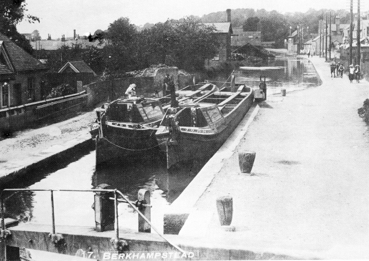
Approaching the Port of
Berkhamsted from the south.
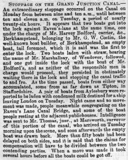
Stoppage at Berkhamsted, Buck
Herald, 1st March 1890.
To the south of Northchurch, the Canal flows into the ‘Port of
Berkhamsted’, or perhaps the former port, for of the eight working
wharfs that once served the town none now remain. [8] The section of
the Canal through Berkhamsted was opened in 1798. Castle Wharf,
between Ravens Lane and Castle Street, became the centre of the
town’s canal trade and it was this area that became known as ‘The
Port’. The town’s commerce then grew rapidly due to this
quicker and cheaper means of transporting the usual bulk
consignments of coal, grain, building materials and manure. Wharves, timber
yards, breweries, boat-building, and later a chemical works, and all
the people associated with these industries flourished as a result. Ironically, the
waterway was later to carry some of the
materials used in the construction of the London & Birmingham
Railway, which following its opening in 1838 captured much of the
Canal’s business leading to a decline in its fortunes.
Among the new businesses that the Canal brought to Berkhamsted was
boat-building. In 1799, the firm of Peacock & Willetts established a
boat-building business on the canal bank at Castle Wharf. Their
first craft, owned by William Butler, was launched in 1801 and
registered the following year in the Company’s Gauging Register. Named
Berkhamsted Castle after the ruined Norman castle that stands nearby,
she was the conventional length for a narrow boat ― 70 ft ― but at
14ft she had twice the beam, making her a river barge. [9] Gauging
records show that she drew 12 inches of water light and 49 inches when
loaded to 65 tons. When inspected she had on board “one
Fire Stove, one Pump, One Anchor and Cable, two Warps (or Hawsers),
one pair of Oars, three Sets, and two Planks”.
The Berkhamsted Castle was the first of 60 boats to be built in
Berkhamsted over the next 125 years. In 1826, the boatyard was
acquired by John Hatton, a boat builder, who appears in local
trade directories for at least the next 55 years. A further change
of ownership came in 1882, when the yard was acquired by William
Edmund Costin, later trading as W. E. Costin Ltd. Again, trade
directories record that he was a boat builder and coal merchant, who
traded at Berkhamsted for almost 30 years in premises described as
“dock, shed and yard, house and water house”. Costins built many of
the boats for the Aylesbury-based canal carrier John Landon & Co.
(later taken over by A. Harvey-Taylor). They were named after towns
in the South of England: Benfleet, Fulham, Blackwall,
Erith,
Guildford, Purfleet, Richmond and Westminster; the last of the
fleet,
the Hythe was launched in June 1909. Other large customers included
the canal carrier L. B. Faulkner of Linslade, who commissioned the
Vulture, Buzzard, Falcon, The Swan, Cygnet,
Dauntless, and White
City. The list goes on, with clients as far away as Birmingham — the
Bourne, Chess, Dane, Danube, Dart, Don, Dove, Isis, and
Wear were
built for the canal carrier, Thomas Clayton Ltd. Shortly before the
boatyard closed, boats constructed for carrying crude tar were built
for Fellows, Morton & Clayton. All these vessels were launched down
the company’s slipway sideways on, with the opposite bank being
sand-bagged.
A wide boat being launched
broadside on, this at Bushell Brother’s boatyard at Tring.
Boat-building ceased in Berkhamsted in 1910, and the premises were
then taken over by William Key & Sons, timber merchants, who became
established after supplying fencing for the London & Birmingham
Railway. The final owner, Bridgewater Boats, refurbished the old
warehouse as a modern dwelling and started a canal boat hire company
catering for the leisure industry. This business closed in 2002 and
the boatyard site is scheduled for redevelopment.
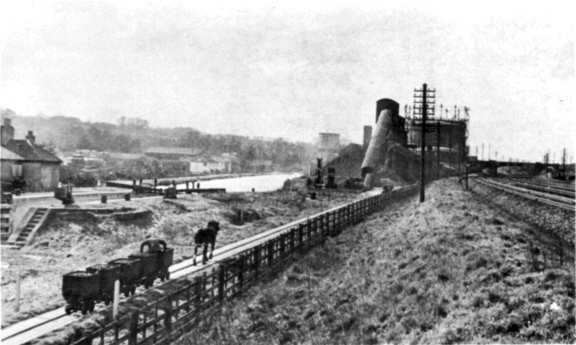
Berkhamsted
Gas Works ― Canal
to the left, West Coast Main Line to the right.
Castle Wharf also serviced ‘The Great Berkhamsted Gas, Light & Coke
Company’. Set up in 1849 to provide street lighting, the original
gasworks was built at the junction of Water Lane and the Wilderness.
Its deliveries of coal were by canal, via Castle Wharf, the gas company
despatching crude tar products to the London area in return. In 1906
the gas works moved to the triangle of land between the Canal and
the railway line east of Billet Lane, coal then being delivered via
a short access line from the railway sidings. Both gas works are
long gone, but a surviving memento of the first is ‘Adelbert House’
in Mill Lane, once the home and office of the Berkhamsted Gas, Light
and Coke Company’s manager.
In 1990,
East & Son of Gossoms End, Berkhamsted, celebrated the founding of
the firm by Job East 150 years earlier. They have made a variety of
timber products including lock gates. Here gates have been loaded by
crane from premises into Prince and princess. The firm supplied 100
head gates and 102 tail gates for the New Hatton Locks in the 1930s.
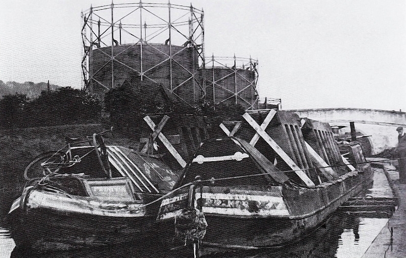
The
gas holders of Berkhamsted Gas Light & Coke Co. are those in the
background.
The largest commercial operation in Berkhamsted to use the Canal was
the chemical business of Cooper, McDougall & Robertson,
manufacturers of sheep dip. This business was started by William
Cooper, a veterinary surgeon, who arrived in the town during the
early 1840s with very little to his name. He began to search for a
formulation that would combat scab in sheep, a type of mange caused
by the sheep scab mite and a condition for which there was then no
cure. By the early 1850s Cooper had developed an effective remedy
comprising arsenic and sulphur, and began its manufacture. So
successful was the product that business grew and with it the
factory premises, which eventually included a wharf where
barges discharged their loads of sulphur, arsenic and coal, and
loaded cases of powdered sheep dip for transportation to the London
docks.
In 1959, Cooper, McDougall & Robertson was acquired by the Wellcome
Foundation, and then in 1992 the French company Roussel acquired the
business and its Berkhamsted site. Having cost a fortune of
detoxify, the former industrial premises was sold and redeveloped
for housing.

――――♦――――
|
 |
|
Boxmoor Wharf to
let: an advertisement from 1815 |
To
the south of Berkhamsted, the Canal continues its descent through Winkwell to Boxmoor,
following closely the course of the River Bulbourne.
Boxmoor Wharf was built by the ‘Box Moor Trustees’ with the proceeds
of the sale (in 1799) of common land at Boxmoor to the Grand Junction Canal
Company, the wharf’s income going towards the relief of the poor at
Hemel Hempstead and Bovingdon. [10]
Later in the century, the wharf became associated with the import of
wines and spirits:
“The best known of the lessees in the 19th century was Mr.
Balderson, who took over the lease in 1856. Henry Balderson was a
notable figure in the town; he was a dealer in coal, coke, stone,
corn, and timber. He was probably better known nationally as an
importer of wines and spirits, especially for his port and Olde
Stone Jar Whiskey. The former came in from Oporto in great barrels,
brought down from London by canal and then bottled at the Wharf. The
boats were called Mildred and Ellen. His son, Robert Henry, joined
the firm in 1890. There is no further record of the name after
1926/7, when it is believed that the business went into
liquidation.”
The Book of Boxmoor,
Hands and Davis (1994)
Boxmoor Wharf and dock
during Balderson’s tenure.
The wharf was taken over in 1947 by Rose’s of St Albans, who were
expanding their lime juice and lime oil refining business . . . .
“The unprocessed lime juice arrived by ship at London’s docks and
the casks were transported by barge down the canal to Boxmoor. Here
the juice was stored in huge oak vats, each holding up to 12,000
gallons. After a time, the clear green-gold juice was drawn off,
filtered and sweetened with pure sugar. It was finally bottled at St
Albans.”
L. Rose & Co.
What was known to boatmen as the ‘barrel run’ took ― on a clear run
― about 12 hours
from Brentford to Boxmoor Wharf. Rose’s was one of the last
companies to use the waterway commercially, ceasing their canal operations in
1981. The site is now occupied by a B&Q DIY store.
Boxmoor Wharf in its limejuice
days. By this date the dock had been filled in.
Another canal-side business based at Boxmoor was Foster’s Saw Mill,
which stood on the site of the present day River Park Gardens.
A mill had stood at Boxmoor since the 18th century, when it was
originally a shoe-heel and clog factory, powered by a water-wheel
driven by the River Bulbourne which ran through the premises.
This was later replaced with a steam engine. In 1930, the mill
was taken over by the firm J. W. Ward of Bourne End. Many
local people were employed there in the preparation and supply of
timber for building, fencing, joinery and even musical instruments.
The mill burnt down in 1967.
――――♦――――
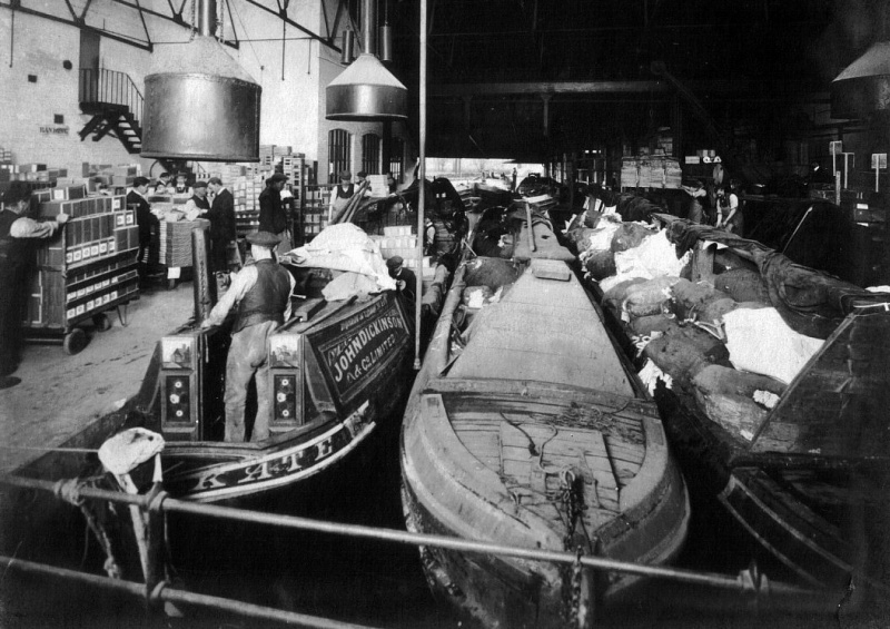
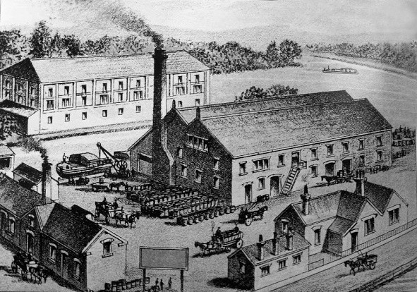
|
Narrow boats at Apsley Mill.
The butty on the left (Kate) is loading finished products, probably
for London. The two on the right appear to be loaded with raw
materials for pulping. In 1890 Fellows, Morton and Clayton
contracted to operate the Dickinson inter-mill service. In
1897 they had replaced horse-drawn boats with the steamers Countess
and Princess together with the butties Maud and May; they were
replaced, in 1910, with Alice and Kate. |
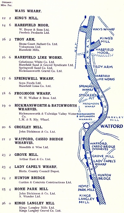
At Two Waters, the River Gade flows into the Canal just above Boxmoor Wharf.
From this point to Rickmansworth
the history of the Canal becomes closely associated with that of paper
manufacturing:
“TWO WATERS, a
village in Herts, two miles S.S.W. from Hemel Hempstead, is
pleasantly situated at the union of the river Gade with Bulbourne
Brook and adjoining the Grand Junction Canal . . . . and in the
village is the elegant little cottage of Henry Fourdrinier Esq.
Two Waters, and its vicinity, have long been noted for the number of
paper mills erected on the sides of the stream; but that belonging
to Mr. Fourdrinier is more particularly worthy of notice, for
containing the invention of manufacturing paper by machinery.
By this machine, and appendant apparatus, every part of the process
is conducted without the intervention of manual labour; and it
cannot fail of exciting surprise in the spectator, on beholding the
rag first washed, then beaten or reduced to pulp; and, lastly,
conducted through pipes to the reservoir of the machine, which
constantly feeds itself, and, in a very few seconds, produces a
paper so perfect in all its parts, that it is wound off upon a reel,
exactly like a web of cloth.”
A Pocket Companion for the tour of London and its
Environs (1811)
A short distance to the south, the Canal begins its journey past the sites of the former John
Dickinson paper mills. In 1819, Hassell described Apsley Mill as:
“. . . .occupying a large space of ground, and rather resembling
a village than a manufactory . . . . Such of our readers who have
never seen the process of manufacturing this useful article, will be
highly gratified in visiting a paper mill. The machinery of this
mill is entirely worked by steam, from the washing of the rags to
the keeping of the pulp in a state of motion, while taken into the
mould from whence it is placed between flannels until it sets; and
afterwards it is pressed, dried and sorted for the market”.
A Tour of the Grand Junction Canal in 1819,
John Hassell
The paper-making process is indeed of interest and today is
demonstrated for the benefit visitors to the ‘Paper
Trail’ Museum at Frogmore Paper Mill, Apsley. Other than the Museum, little now remains of the
site as Hassell saw it, for following company acquisitions and closures
during the 1990s the former Dickinson paper mills received the attention of the
residential property developer.
Irascible though he was, John Dickinson was no fool [11]
and he and the Company were to have a close business relationship
over many years, hostile at times, but overall to their mutual
benefit. Originally the firm owned its canal boats, but in
1890 the canal carrier Fellows, Morton and Clayton contracted to
operate Dickinson’s inter-mill service. [12] FMC
replaced Dickinson’s horse-drawn boats first, with steamers, and
then in 1927 with motor boats. These were used to convey the
firm’s products to London, with return cargoes of raw materials such
as waste paper, rags, esparto grass, wood pulp, chemicals and china
clay. Following their conversion from water to steam power,
large quantities of coal were also shipped to the mills from the
Warwickshire coal fields. During the 1870s and 80s:
“Coal came by boat. At Nash Mills it had to be wheeled from
the wharf on the canal, over the Mill Head Bridge and down the
garden path on to the tip, a run of from eighty to one hundred feet.
A gang of six men was made up to wheel in the sixty tons from two
boats, the pay being 4d. per ton and thirty-six pints of beer (drawn
from two barrels kept on the premises), this working out to about
4s. plus six pints per man. The other mills allowed beer for
this work but were less generous in quantity.”
The Endless Web, Dame
Joan Evans, 1955
Among its many exhibits the Paper Trail Museum displays a
“Register of boats and coal arrival 7/1933 to 26/6/1942” at
Apsley Mill, which records pairs of narrowboats delivering around 53
tons of coal every two to three days:
“Most of the coal-boat skippers were Number Ones ― working
owners, whose wives and families were the crew. They all lived
aboard, in the tiny cabins of the leading and towed ‘butty’ boat,
the round trip from Warwickshire taking ten to twelve days. . . . It
was 1927 before the first Number One acquired a motor-driven boat
and cut the round trip time to four days.”
Canal Memories, pub.
Dacorum Heritage Trust (1999)
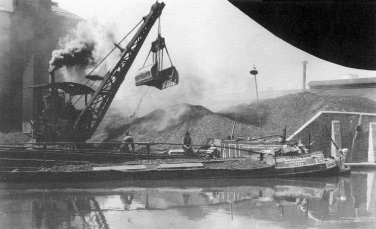
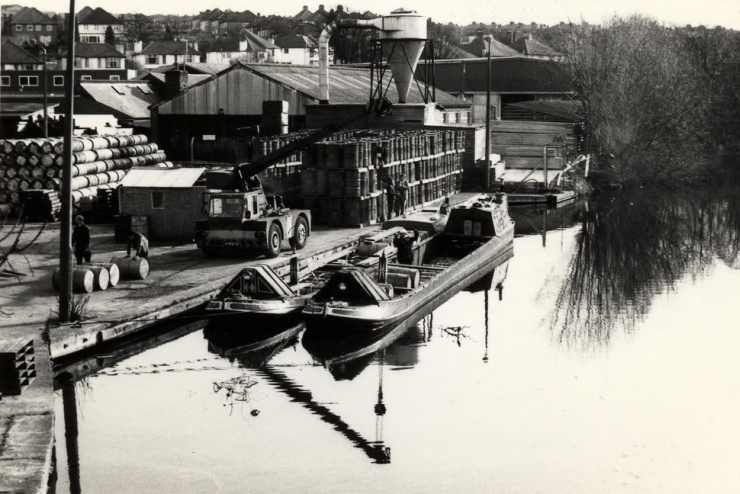
|
Discharging coal at Apsley
Mill. The Dickinson paper mills in the Apsley area closed in
1999, and the land has since been redeveloped.
Nash Mill was sold to the Sappi Group and continued to
make paper until 2006, when it too closed. |
During the 1960s the paper mills switched to oil-fired boilers and
coal deliveries ceased.
Just south of Apsley the canal passes the former site of Nash Mills,
another of Dickinson’s paper mills. During the construction of
the London & Birmingham Railway, the artist John Cooke Bourne made a
series of sketches of the railway under construction that included
an illustration of Robert Stephenson’s fine skew railway bridge,
which crosses the Canal near to this point. It is near the
location of this bridge that the southern end of the 1818 deviation
returns to the course of the original Canal.
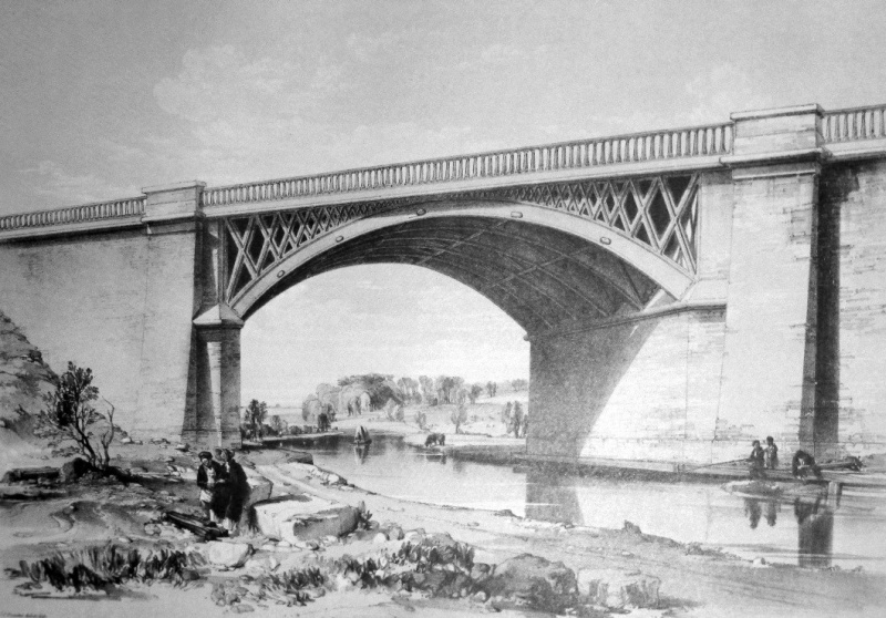
Nash Mills Railway Bridge and the Grand
Junction Canal, by John Cooke Bourne.
――――♦――――
Continuing south of Nash Mills railway bridge, the
Canal reaches
Kings Langley and the site of Toovey’s Flour Mill. A mill stood here
on the River Gade long before the Canal arrived to pass close by. Following a dispute with Thomas Toovey, the
miller, over water rights, the Company bought his mill and leased it
back to him. The family-run business kept pace with
technical developments, installing, in 1894, steam power and the new
‘roller’ milling process by which grain is ground by a succession of steel
rollers (rather than with traditional millstones) in a gradual
reduction process, a system that
continues in use today. The firm maintained its own wharf and canal
boats, which carried imported grain from Brentford to the Kings
Langley mill. Records show that the Tring boat-builder Bushell
Brothers
constructed a pair of horse-drawn ‘wide boats’ (11 ft beam), the Langley and the
Betty, for Toovey in 1916.
‘Golden Spray’ was Toovey’s top grade flour and a canal boat
registered in 1922 in the name of T. W. Toovey carried that name. The firm continued in business until 1978 when it went into
voluntary liquidation. The machinery was then sold by auction and the
mill demolished.
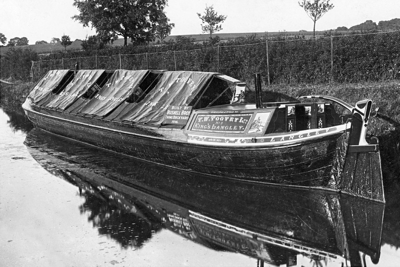
|
The board for’ard of the cabin
proudly proclaims the Langley to be a product of Bushell Brother’s,
Tring Dockyard, where she is pictured.
Bushell’s received a repeat order in 1922, which resulted in the
‘Golden Spray’. Both were wide boats. |
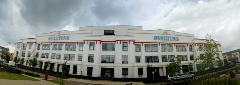
Photo: meophamman
A short distance to the south of Toovey’s Mill stood the factory of
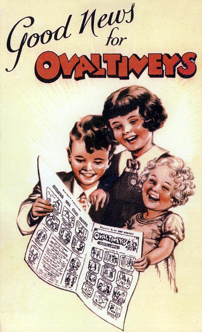
A. Wander Ltd., manufacturers of the malted dairy drink ‘Ovaltine’.
Ovaltine ― formerly ‘Ovomaltine’, from ovum, Latin for egg, and malt, originally
its main ingredients ― was created in the 1860s by Dr George Wander,
a Swiss chemist, to exploit the nutritional value of malted barley. Its success was such that the product was marketed internationally.
|
 |
|
Discharging coal at
the Ovaltine factory |
The manufacture of Ovaltine commenced at Kings Langley on a small
scale in 1913. Sales grew and a much larger factory, the fine façade
of which remains, was built on the site between 1924 and 1929.
Erected by C. Miskin and Sons of St Albans, oddly, the architect of
this art deco masterpiece is unknown. To
ensure that supplies kept pace with the company’s growing demand for
barley, eggs and milk, two nearby farms were bought to provide Ovaltine’s natural ingredients. Known as the
‘Model Poultry’ and ‘Dairy’
farms, they were rebuilt in precise imitation of the farm that King Louis XVI
of France built for Queen Marie Antoinette, and featured
regularly in the firm’s advertising to promote their drink’s
wholesome qualities.
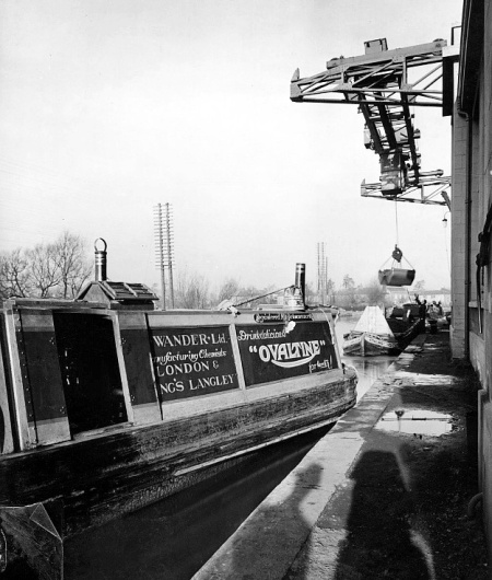
The canal-side location of Wander’s factory allowed the coal
needed to fire its boilers to be delivered direct from the
Warwickshire collieries, narrowboats completing the 10 to 14 day
round trip in a continuous circuit. In 1925, the firm introduced its
own fleet of boats, the first pair, the motorboat Albert and the
butty Georgette, entering service in January 1926. At its peak, the
Ovaltine fleet totalled seven pairs of narrowboats, but by 1954 it
had reduced to 3 pairs and contractors were increasingly delivering
the coal. Eventually the company switched to oil, the last delivery
of coal being made in April 1959.
In 2002, production of Ovaltine was transferred to Switzerland by
its then owners Novartis and the factory was sold for residential
development, which was described in the advertising as
“Luxury apartments and stylish townhouses on a popular Art Deco
development with historic charm”.
Both Toovey and Ovaltine made use of the Kings Langley section of
the Canal towards the end of its commercial life, but in
its early days the Canal served a much more agrarian society, as
was recorded by Arthur Young, an eighteenth century writer on agriculture:
|
“Mr. Newman Hatley, a considerable farmer at King’s Langley, has
opened a trade upon the canal, in order to give him a greater
command of manure for his farm. I was solicitous to know at what
expense a barge could be kept constantly in employment: he favoured
me with the following particulars.
“The barges carry 60 tons; and their construction costs £262-10s. They are navigated by a bargeman and his boy, and one other man,
with three horses: the bargeman and boy cost £2-12s-6d. a week; the
man 17s. A voyage takes ten days; locks and dues on a load of manure
amount to £5. Hay pays three farthings a mile per ton; the distance
extends 25 miles. Corn and other goods, 1½d. I was informed, that a
barge-load of night-soil [13] and sweepings of streets, in a compost,
costs at London £12.”
The Agriculture of Hertfordshire,
Arthur Young (1804) |
――――♦――――
To
the south of Kings Langley, the canal passes under the M25 viaduct
to reach lock 74, adjacent to which is the former ‘Lady Capel’s
Wharf’, a name that stems from the Capel family, earls of Essex. In
1546 Henry VIII granted the Manor of Cassiobury to Sir Richard
Morrison, who, with his son Charles, built a large house and
extensive gardens. In 1627 Charles’s daughter, Elizabeth, married
Arthur Capel (1610-1649) and the estate passed into the Capel
family. At the Restoration, King Charles II made Arthur Capel 1st
Earl of Essex.
A river barge at Hunton Bridge
― an early colour photograph (Vivex) from the 1930s.
The 4th Earl, William Anne (sic.) Capell (1732-99), was one of the
noblemen on the Grand Junction Canal Company’s board, and at his insistence the
Canal
was widened and landscaped where it passed through his estate. The
name ‘Lady Capel’ persists, although the wharf, which was a mile or
so north of the present park, is long gone. It was here that
large shipments of coal were landed due to a monopoly enforced by
the early Canal Acts, which barred coal from being conveyed
any further south. The 1793 Act makes clear the harsh penalties
awaiting any boat owner intent on breaking the monopoly:
“. . . . the conveying of Coals from the Collieries of
Warwickshire, Staffordshire, Leicestershire, and Derbyshire, by the
said intended Canal, to the City of London, may be detrimental to
the Coasting Trade of this Kingdom, by diminishing the Consumption
of Coals brought to the Port of London by Coasting Vessels; be it
therefore enacted, That no Coal, or Culm, or Cinders burnt from Coal
or Culm, which shall pass along the said intended Canal and
Collateral Cuts, or any Part thereof, shall be conveyed nearer to
the City of London than the Mouth of the intended Tunnel at Langley
Bury, in the County of Hertford, by any Barge, Boat, or other
Vessel, on Pain of Forfeiture of every such Barge, Boat, or Vessel,
and of all such Coal, Culm, or Cinders, as shall be on board the
same, and also on pain of forfeiting the Sum of Fifty Pounds by the
Owner or Owners of every such Barge, Boat, or Vessel . . . .”
Grand Junction Canal Act, 1793
In the event the Canal did not follow its intended path through the
“Tunnel at Langley Bury”, and the boundary of the coal monopoly was
transferred to the north-eastern edge of Grove Park, which is where
Lady Capel’s Wharf was located. [14] The monopoly was later relaxed to permit the
transit of 50,000 tons, a weight limit that was later removed, but subject
to the payment of ‘coal duty’ ― which in 1831 was £1-1s per ton ―
and Lady Capel’s Wharf became the nearest point at which coal for
Watford could be offloaded without payment of the duty. Officials
were stationed at the boundary marker to collect the duty and to
record the tonnage that passed.
Coal duty was introduced in the 17th century [15] as one of a range of
duties levied on some types of goods entering the Port of London and
certain surrounding areas. The proceeds were used to help finance
rebuilding following the Great Fire of London (1666). Buildings
damaged or destroyed in the fire that benefitted from the duty
included Saint Paul’s Cathedral and many of the City’s churches, the
Guildhall, the City’s markets and Newgate Prison. Eventually
numerous of the Capital’s public works and causes came to be funded
in this way such as (in the 19th century) the construction of the
Victoria, Albert and Chelsea Embankments, Northumberland Avenue,
Hyde Park Corner and the northern and southern outfall sewers (which
were largely responsible for wiping out cholera in London). When, in 1861, the area for the coal duty was altered to coincide
with the Metropolitan Police District, the coal duty boundary was
transferred to Stocker’s Lock near Rickmansworth. Coal duty was
eventually abolished in 1890.
――――♦――――
At
the north-eastern edge of Grove Park, the line
followed by the Canal today lies to the east of that authorised
originally by Parliament. The intention had been to cross the River Gade on an
aqueduct near to Kings Langley and then to drive a tunnel through
the high ground behind Langleybury House, then to pass down the western side
of the Gade Valley and descend into Rickmansworth through a
flight of locks. It is possible that this route was influenced by a wish
to avoid confrontation with the influential
owners of the Langleybury, Grove and Cassiobury estates that lay in
the river valley, then the domains of Sir John Filmer and the Earls
of Clarendon and of Essex respectively. But equally, driving a
tunnel at that time was, as Braunston and especially Blisworth
were to demonstrate, an engineering challenge fraught with risk.
The alternative line down the eastern side of the Gade Valley would
not only avoid the need for the aqueduct and tunnel, but take the Canal nearer to
Watford. At the General Assembly of November 1797 ― with the experience of tunnelling at Blisworth
by then before
them ― the Committee explained the change of line in the Gade Valley, stating simply that “the importance of avoiding a tunnel, few will now
dispute”. [16] And none did.
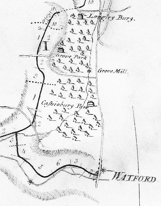
The intended line of the
Canal ran down the western side of the River Gade
Valley
― the line
taken followed the Gade, shown at the centre of the map
A contract to drive the Langleybury tunnel having already been let,
the Company Chairman, William Praed, entered into negotiations to
purchase land for the deviation that is followed today. Writing some
years after the event, Arthur Young had this to say:
“The proprietors of the navigation proposed to tunnel under
Crossley-hill, but the Earl of Essex, actuated by motives of
patriotism becoming his high rank, and consonant with his
philanthropy, agreed that the navigation should pass through his
park, which it accordingly does; great expense in tunnelling was
thus saved to the proprietors, and of freight in course to the
public.”
General View of the Agriculture of Hertfordshire,
Arthur Young (1804)
. . . . and John Hassell was also to join in the
kowtowing:
”Ready permission was granted by the present Earl of Clarendon,
and the late Earl of Essex, to allow this great national undertaking
to pass through their respective parks; and when we find the
opposition that the Duke of Bridgewater was continually receiving,
from parties, through whose premises he was unavoidably often
obliged to pass his navigable canals, it must stand as a monumental
record, and example of the urbanity and amor patriæ, these
distinguished noblemen exhibited for the weal of their country.”
[17]
A Tour of the Grand Junction Canal in 1819,
John Hassell
No doubt these patriotic landowners received adequate financial
compensation; in fact the Earl of Essex held out for a better price,
which he received. Their Lordships did, however, insist on clauses
in the Act that authorised the altered route, to stipulate that the
sections of canal that ran through their domains be made as
attractive as possible. And so they were and now form a delightful walk.
Cassio Wharf, at the southern end of Cassiobury Park, was the
nearest wharf to Watford; today the site is occupied by a marina. A
branch canal into Watford and onwards to St. Albans was in fact
authorised by Parliament in 1795, but in the cold light of day ― despite much agitation from the
citizens of both towns ― it must have appeared to the Company that the
costs of building and maintaining the Watford/Saint Albans branch outweighed
its likely
benefits:
”An act passed for another canal from St. Albans, to join the
Grand Junction below Cassiobury-park; but for want of power to raise
£17,000 by subscriptions, nothing has yet been done towards carrying
it into execution.”
General View of the Agriculture of Hertfordshire,
Arthur Young (1804)
Plans for the 2-mile
Watford Arm show that it would have departed the main line in the
vicinity of Croxley (lock 79) to terminate in a basin to the north of
the site now occupied by Bushy Station. Barnes surveyed the 9-mile
extension to St. Albans in 1792. This he planned to commence from the
vicinity of the Watford basin, then, following the course of the
rivers Colne and Ver (sections of each being canalised), would
terminate in a basin in the Ver valley about 1-mile to the
south-east of St. Albans Abbey.
In passing it is worth mentioning that other proposed branches for
which Acts were not obtained were to Chesham, Dunstable and Hemel
Hempstead. The 1-mile branch canal to Daventry was authorised by
Parliament, but not proceeded with; it is still discussed today, as
is a once-mooted branch from the locality of Fenny Stratford to
Bedford. In none of these cases does the business case appear to
have been sufficiently robust to justify the costs of overcoming
resistance from landowners and of construction.
――――♦――――
Croxley Mill
At the southern end of the Gade Valley the
Canal reaches Croxley and further territory once occupied
by John Dickinson’s paper-making empire. In 1830, Dickinson opened a
canal-side paper mill on Common Moor, which by 1838 was producing 14 tons of paper
a week. Papermaking was eventually transferred to Croxley Mill from Apsley
and Home Park (Nash Mill continued to manufacture specialist papers)
and by 1894 weekly output at Croxley had risen to 140 tons.
Croxley mill was mostly steam-powered, the coal to fire its furnaces
being transported by canal. Writing in 1896, Lewis Evans [18] gives an
interesting description of the factory’s coal deliveries:
“The actual buildings of the mill cover an area of about 24,000
square yards, or nearly five acres. The power for driving the
machinery is almost entirely derived from steam engines . . . .The
coal shed occupies an area of 200 ft. by 50 ft., and is capable of
holding 4,000 tons of coal . . . . The coal is unloaded from boats
on the Grand Junction Canal by a kind of dredging machine, which
delivers it to an endless chain-conveyor running in a trough along
the top of the shed. There are gratings in the bottom of this trough
through which the small coal can drop, the lumps which are too big
for the mechanical stokers passing on to the other end of the shed. The chain returns along the shed in an underground tunnel, the coal
for the boilers dropping on to it through openings in the floor, and
so being carried along for delivery to a second chain, which conveys
it over the mill-tail to the chimney, where it is elevated to a
third chain passing along the top of the boiler-house. This chain
distributes the coal down chutes to feed the mechanical stokers on
the boilers, the ashes and clinkers being carried out of the house
by the returning chain.”
The Firm of John Dickinson & Co. Ltd.,
Lewis Evans (1896)
Croxley Mill depended largely on the Canal not only of supplies of
coal from the Midlands, but for its but raw materials brought up
from the London Docks by barges and lighters and for the export of
its finished products:
“Though the mills were all established before the age of
railways, Mr. Dickinson with his usual forethought chose for his
enterprise a locality provided with excellent water-carriage, and
though the London and North Western Railway now passes close to
three of the mills, and one of its branch lines near to the other,
water-carriage is still found to be the cheaper and cleaner, so that
the greater part of the traffic of all the mills is even now carried
on by means of the GJC, on which there are quite a fleet of boats
employed in bringing coal and materials to the mills, and in taking
away paper and stationery. These boats each carry about twenty-five
tons at a time, and every evening paper leaves the mills by them,
and is delivered in London next morning at six at the company’s
warehouse, Irongate Wharf, Paddington.”
The Firm of John Dickinson & Co. Ltd.,
Lewis Evans (1896)
But progress gradually overtook the leisurely pace of canal
transport. In 1937, articulated lorries took over the Apsley to
London run to collect esparto grass [19] and wood-pulp from the docks,
while the inter-mill barge service ceased in 1947. Coal deliveries
by canal continued until 1970, when Croxley switched to oil firing.
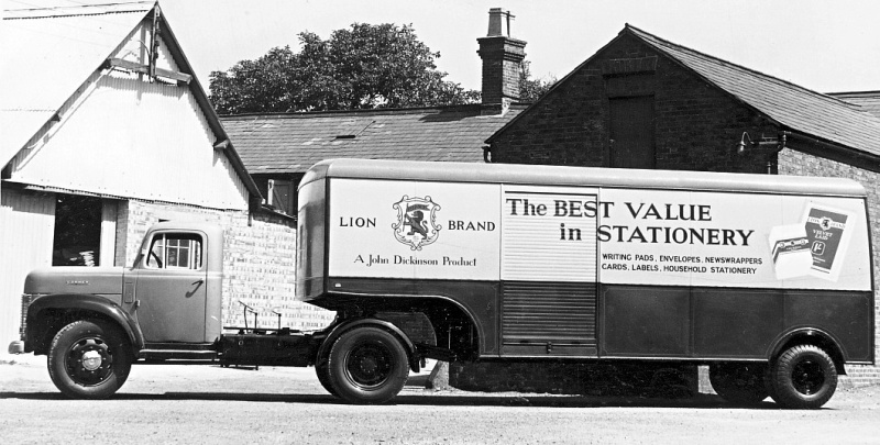
A Commer articulated truck in John
Dickinson livery pictured at Tring Dockyard where Bushell Brothers
had built the
bodywork.
――――♦――――
“Owing to the heavy rain, the water has overflowed the banks of
the river Colne and Gade, so that the meadows in the neighbourhood
of Watford and Rickmansworth are completely covered, and a great
quantity of hay is washed away. A barge belonging to Mr. Moses
Robinson, of Birmingham, was driven on the bank of the Grand
Junction canal, about a quarter of a mile from the town of
Rickmansworth, on Friday morning, and instantly went to the bottom.
It was loaded with iron bedsteads. A woman and two children very
narrowly escaped a watery grave.”
Jackson’s Oxford Journal,
3rd July, 1824
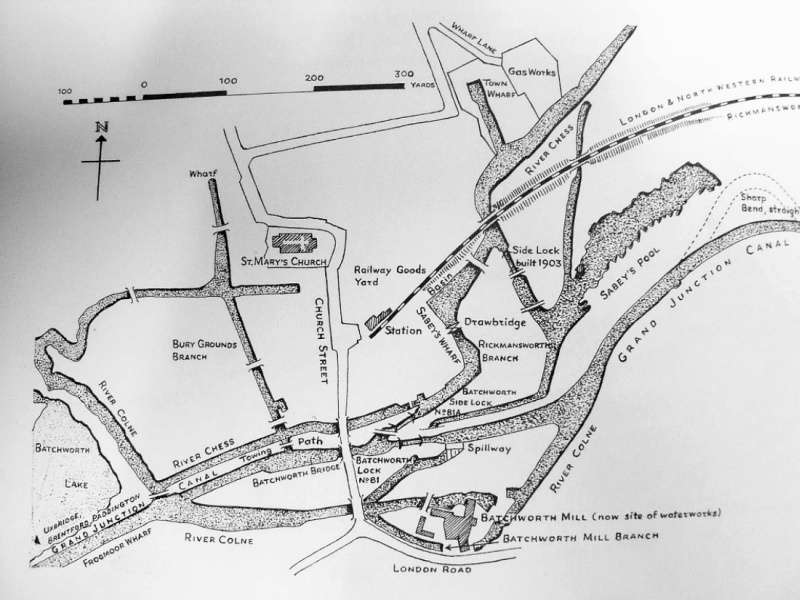
Rickmansworth stands at the confluence of the rivers Gade, Chess
(which flows into the town from Chesham to the north), Colne (which
flows into the town from Watford) and the Grand Junction Canal,
which, in 1796, arrived from the south to establish a link with the
Thames at Brentford. Local businesses soon began to use the
Canal, especially when a short branch was constructed to a wharf
just off the town centre. A century later, Wilson’s
Imperial Gazetteer of England and Wales described Rickmansworth
as a small town with:
“. . . . a railway station, a banking office, a good inn, a
timbered market house on pillars, a church, Baptist and Wesleyan
chapels, an endowed school with £24 a year, alms-houses with £10,
other charities £32, an extensive brewery, a silk mill, four paper
mills, cattle fairs on 20 July and 24 Nov., and a fair on the
Saturday before the third Monday of Sept.”
Waterways (shaded) at
Rickmansworth c.1870.
The railway, brewery and the paper mills referred to all benefitted
from links to the Canal, as did a bakery and, later, a boatyard.
The railway was the Watford & Rickmansworth Railway. Opened in 1862,
the line was never profitable and even less so when, following the
arrival of the Metropolitan Railway in 1887, the town was
connected directly with London. [20] Electrification in 1927 didn’t
ensure the line’s future; it
closed to passengers in 1952 and to freight in 1967. The railway’s
Rickmansworth terminus and goods yard, which was located opposite the parish
church, included a freight interchange siding with the Canal.
Salter’s brewery met with more success than the railway. The
Salter family’s connection with brewing dates from the 17th Century,
but it was only when Stephen Salter took over the business in 1750
that it began to grow. His nephew, who succeeded him, paid for
the River Chess to be made navigable for some 500 yards to the
firm’s brewery and maltings. Opened in 1804, Salter’s Cut [21] joins the Canal through a lock adjacent to Batchworth
Lock. Its main traffic was barrels of beer for Uxbridge with
the empties in return, although grain for malting and coal were
probably landed there as well. Besides
serving the brewery, the cut also served Town Wharf, the Rickmansworth gas works and a gravel pit
(Sabey’s Pool). [22]
In 1820, a short section of the River Colne just to the south
of Batchworth Lock was also canalised and used to convey shipments to Batchworth Mill.
The mill was used originally to spin cotton, its
machinery being powered by a waterwheel driven by the river.
Following the Canal’s arrival, there began a long-running dispute
over water levels at Batchworth. In 1809, the Company bought
the mill to obtain its water rights before selling it on, ex water
rights. In 1818, the mill was bought by John Dickinson and
converted to a ‘half-stuff’ mill, one in which rags and other
materials were prepared for turning into pulp at Dickinson’s other
mills, the output being transported to them by canal. But it
seems that the disputes over water continued until 1825, when a stone obelisk was erected in a pond to
act as a water gauge, the Company being liable for compensation
should the water level fall below a mark on the gauge. The
obelisk, which still stands, records the agreement made between the Company, John
Dickinson and R. Williams of Moor Park, who was the landowner. In 1886, following
the expansion of Croxley Mill (which by
then covered 16 acres), the smaller Dickinson mills became redundant
and Batchworth rag mill was sold and later demolished, the cut to
the mill being filled in 1906 when the London Road was widened.
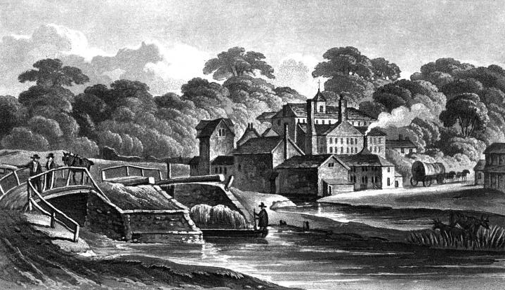
John Hassell’s sketch of
Batchworth locks and mill c.1819. Salter’s
Cut departs under the bridge on the left.
The mill was demolished
in the early years of the 20th century.
It is unusual to find a bakery served by
its own canal, albeit of a mere 300
yards in length, but such was the case at Rickmansworth. Taylor’s
Cut ran from a point just below Batchworth Bridge to a wharf
situated in the grounds of ‘The Bury’, the principal manor house of
the medieval manor of Rickmansworth. In 1843 The Bury was bought by
John Taylor, a coal and coke merchant who developed interests in
flour, grain and baking. Taylor built a cut, which passed in front
of the manor and nearby stable block to a wharf. Here, he unloaded
barges, their cargoes being stored in parts of the manor house that
he put to use as a warehouse ― unsurprisingly, the premises
are reported to have
deteriorated seriously by the time of his death in 1868.
Before leaving Rickmansworth, one further business should be
mentioned, that of W. H. Walker and Brothers, which besides trading
in timber, building materials, coal and coke, also ran a boat
building and repair yard. The firm were based at Frogmore
Wharf, now the site of a Tesco supermarket. During its years
in operation (1905-64), the boatyard became one of the canal network’s most
successful builders, launching 212 new boats and repairing over 600 others. Walkers specialised in wooden construction,
[23] building boats for,
among others, the canal carriers Fellows Morton and Clayton and the
Grand Union Canal Carrying Company, and for the manufacturing firms
of Cadbury of Bourneville and Wander (Ovaltine) of Kings Langley.
Batchworth Lock and the
entrance to Salter’s Cut on the left (a nice little tea shop exists
in between).
――――♦――――
 |
 |
|
The Stocker’s house and the London
Coal Duty marker.
“House. 1861-2. Built for the
City of London Corporation as a residence for its Collector of the
Coal Dues on the Grand Junction Canal. Stock brick.
Shallow hipped slate roof. 3 bays. Tall 2 storey front
with steps up to central entrance with a panelled door and
rectangular fanlight all in a rebated reveal. Large glazing
bar sashes in reveals.”
Grade II listing ― English National
Heritage description (extract) of Stocker’s House. |
South of Rickmansworth, below bridge 175, stands Stocker’s House, built in 1861 for the Collector of Coal Duties when the
boundary was relocated from its original position at The Grove near
Watford. This splendid Victorian dwelling suggests
that considerable status was attached to the Collector’s role. The
actual point at which duty became payable is designated by ― in the
words of English Heritage ― a “City of London Coal Duty Marker.
1861. Cast by H. Grissell, Regents Canal Ironworks. Cast-iron square
pier, one and a half metres high, painted white”. Both marker
and house are Grade II listed monuments.
Black Jack’s lock (No. 85) and watermill (now a guesthouse) lie a
couple of miles further south. The story behind the name is that the
mill and lock were named after a black slave who was bought and sold
with the land. With his donkey and cart, Black Jack delivered to its
customers the flour ground in the mill.
Nearby, at West Hyde, is Troy Cut, a 1,000-yard branch off the canal
built to serve Troy Mill. When milling ceased, the cut was
used to ship sand and gravel from nearby pits, now worked out. Indeed, the section of the
Canal between Rickmansworth and Denham is
lined with numerous worked-out gravel pits, now flooded and the
haunt of wildlife, fishermen and the occasional marina. And it was
in one such pit, during the 1950s, that the British Transport
Commission, who then ran the canal network, scuttled many redundant
narrow boats. . . .
. . . . an extract from the Inland Waterways Bulletin for
December, 1959, tells the story:
“We have more information about the sinking of narrow boats in
Harefield Flash . . . . Further investigation has disclosed that not
six boats have been sunk, but twenty-four. None of these appear to
have been offered for sale; though a firm of carriers inform us that
they might have purchased several, and the demand for converted
narrow boats is now so great that, for better or for worse, almost
any craft that will float at all, can be sold. British Waterways
themselves keep a list of applicants for boats suited to conversion.
Instead of offering the boats for sale, British Waterways apparently
paid the owners of the water where the sinkings took place, a
substantial sum, in the same way that payment is made for the
privilege of using land as a rubbish dump; and that they paid also
for a breach to be made, and later repaired, in a dyke, 20’ wide and
3’ high, which separates the subsidiary flash (normally an isolated
lake), from the main flash, which is accessible from the canal. The
boats were towed through this temporary channel, and then sunk right
across the subsidiary flash, like the fleet at Scapa Flow. Finally,
all these operations appear to have been carried out at a week-end,
on overtime. One can perhaps surmise why.”
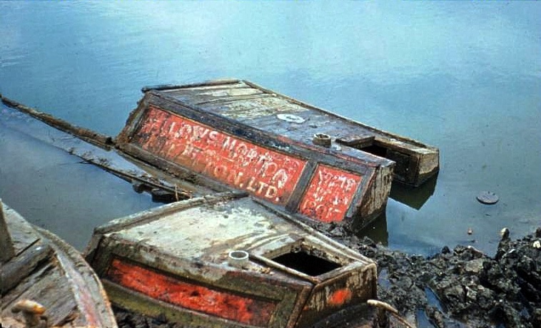
Recent research suggests that over 50 boats share this watery
resting place including Daisy, once owned by the Aylesbury canal
carrier, A. Harvey-Taylor.