|
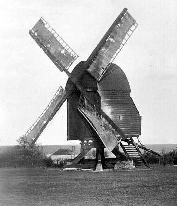
“This is another of the remaining open
trestle post mills. It is in bad condition. One of the sails remains
with its end resting on the ground, and so helping to support the
body of the mill. It ceased working before the war . . . . This is
one of a group of mills with three, instead of two cross-tree
timbers, and six, instead of four quarter bars [Chinnor
being another] . . . . This mill is not marked
on an old map of 1797, and as its appearance suggests a greater age
than one is led to suppose, it may have been brought from elsewhere
and erected on its present site.”
English Windmills, Vol. 2, 1932
Piecing together a windmill’s history
is usually much more of a challenge than locating it,
for windmills rarely attracted much attention during their lifetime and
it is not unusual to find that little or no
documentary evidence survives.
Nevertheless, when taken together, parish records, local trade directories,
newspapers, auctioneers’ catalogues and letters of the period can
sometimes provide a sketchy outline, as this
chapter illustrates. Then there are old books; fortunately, enthusiasts such as Stanley Freese, Rex Wales
and Donald Smith were around when windmills that are now long gone were
still to be seen — even if only their
remains — and they recorded for posterity what they saw and
learned about a windmill’s history, usually from people who could
remember the mill at work, or even worked in it.
Thus, what follows is sometimes little more than a mention of
some of the undoubtedly many windmills that once worked in
north-west Hertfordshire and over the county boundary into parts of
Buckinghamshire.
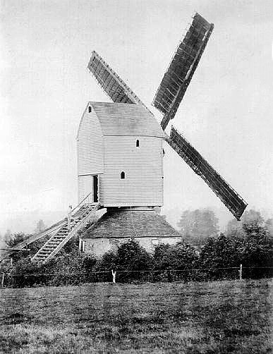
Fig. 14.2: Cuddington
post mill near Aylesbury, seen in 1894.
This post mill was demolished c.1925
TRING
From the time of Domesday until the middle of the 16th century,
streams in and around Tring drove three different watermills; so it
can be assumed that in medieval times there was probably no need to erect any
windmills, or if there were any they are unrecorded. The
watermill at Gamnel was bought by the Grand Junction Canal Company
to acquire its water rights, but when the
other watermills fell into disuse is not known. The first windmill
map symbol for
Tring appeared in 1766 on a map surveyed by the famous
cartographers Dury and Andrews.
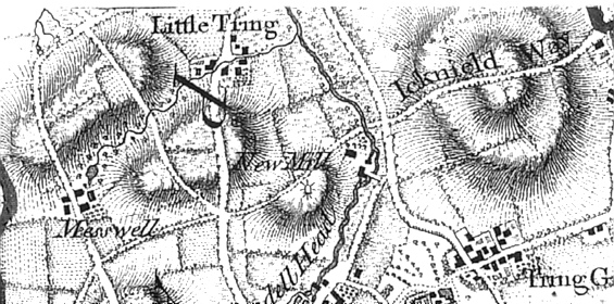
Fig. 14.3: c.1766 —a windmill
symbol is at the centre of the map, under ‘New Mill’
(an area of
Tring which has retained that name)
and to the right of the intersection
of the present day
Dundale Road and
Icknield Way.
The windmill depicted on this map (fig. 14.3) was sited three
quarters of a mile north of the parish church, on the Icknield Way
and to the east of what is now Dundale Road; on the map, the area is
called ‘New Mill’, a name that it has retained. A windmill is also shown in this position on the Inclosure map of 1797; valued by the Commissioners at 6s.2d., it is
listed as belonging to Edward Foster’s Trustees. No other records of Tring’s old windmill on Icknield
Way are mentioned in any local records. The late local
historian Bob Grace, who
owned Grace’s Maltings in Akeman Street, claimed that a 3ft ‘Cullin
Stone’ (a name given by millers to black millstones imported from
the Cologne area of Germany) from this old post mill was set into
the courtyard of his premises.
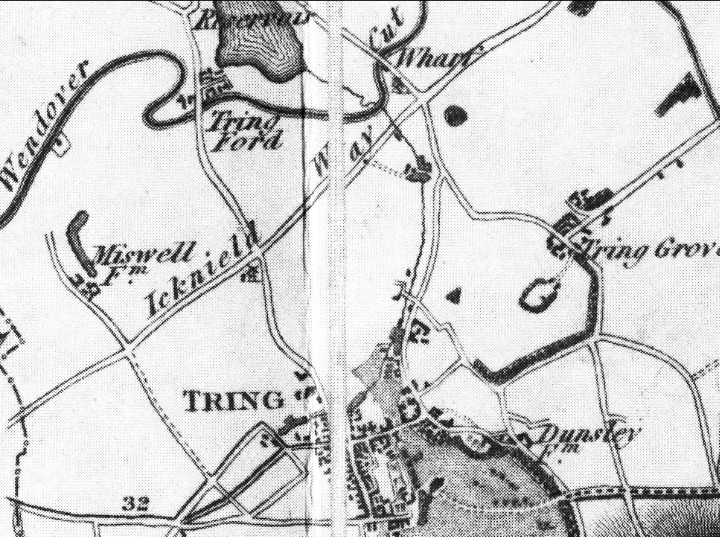
Fig 14.5: Bryant’s Map of
1820. A windmill (unknown) symbol
appears under the “eld”
of Icknield
Before leaving Tring, it is worth mentioning that a windmill symbol appears
on Bryant’s Map of 1820
(fig. 14.5). It is also located on Icknield Way at the
junction with Dundale Road, but further
west than the ‘New Mill’ mentioned earlier. This symbol might
in fact refer to the ‘New Mill’, with either Bryant’s or Dury &
Andrews’ map containing an error as to its location. It is
also possible that Dury’s map might correctly mark the location of
an entirely different mill of
which nothing now is known, or that the ‘New Mill’ was moved.
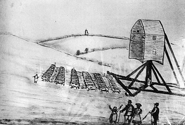
Fig. 14.4: moving a post mill
using a sled hauled by a team of oxen
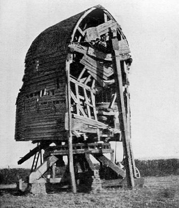
Although uncommon, windmills were moved occasionally, as this
account of the procedure for bodily removing a post mill illustrates
. . . .
“If the main post and crosstrees were to be retained, they might be
removed complete with the mill carcass; the crosstrees [fig. 2.2]
would be shored up, brick piers demolished, and the trolley run
underneath the structure, which was then let down bit by bit with
jacks and levers. Sometimes in Suffolk two ‘drogues’ (or timber
wagons) were lashed together side-by-side, two arms of the
crosstrees being rested on one, and two on the other . . .”
. . . . and many horses or oxen were then teamed to haul the
resulting load. But were the mill was to be moved any
distance, this could only be achieved by dismantling it; an example
here is the smock mill at Lacy Green, which originally stood at
Chesham. In 1821, it was dismantled and reassembled some
9-miles to the west on its present site at Lacy Green (Chapter
XIII).
ALDBURY
In Aldbury the Open Village, (pub. 1987), Jean Davis, the Aldbury
historian, writes that . . . .
“. . . . in the southwest corner of Aldbury Parish, Great and Little
Windmill Fields recall the mill which would have served Pendley
Manor, but as early as 1354 it was in very bad condition.”
Two maps of Aldbury, one dated 1762 and the other 1803, show a ‘Great
Windmill Field’ and a ‘Little Windmill Field’ in an area about one and
a quarter miles south-west of the church. These fields are near both
the Tring and Wigginton parish boundaries with Aldbury, and an
account of the bounds of Tring Manor in 1650 contains what seems to
be a reference to this windmill site. . . .
“. . . . and soe a longe the highway between Aldbury ffield and
Tringe ffield and soe to Pendley Lockshops and from thence unto
Pendley gate and from thence to Windmill Corner and from thence to
old well . . . .”
These references to known landmarks locate ‘Windmill Corner’ as
adjacent to the ‘Windmill Fields’.
Even more mystery surrounds the second windmill in Aldbury. A rental
document, with an approximate date of 1501, mentions a “wynd Milfelde”, the site being about two-thirds of a mile west-north-west
of the church. Further evidence of a windmill in this position comes
from a map of the Duke of Bridgewater’s estate dated 1762 which
names a ‘Windmill Hill’. On an aerial photograph of 1972, there is a
circular crop mark in the position where it is thought to have been
sited.
A further shred of evidence can be found in the Victoria County
History of Hertford (Vol.2), which states that a windmill was
erected in Aldbury towards the end of the 16th century. In 1589-90,
a licence was asked for by Thomas Kynge to erect a cottage for the
miller “a painfull man in his calling”. This latter does not quite
agree with the other dates, but in discussing matters so long ago, a
difference of one hundred years has sometimes to be expected; all
that is certain is that there has been no working windmill at Aldbury for a very long time.
PITSTONE’S OTHER WINDMILL
The post mill at Pitstone (Chapter VI), now in the care of the
National Trust, is well known and documented. What is less known —
indeed, almost unknown — is that it once had a near neighbour,
another post mill, which was located on land that is now part of the Castle Mead estate.
The sole documentary evidence for this mill lies in an
account written during the 1930s by the windmills author, Stanley Freese. Freese admits that the mill is not shown on
standard maps of the period, “although the early 6in and 25in O.S.
outlined the mill mound without naming it”. However, local
historians at Pitstone Green Museum were able to locate the mill on
an undated tithe map, where it is shown standing adjacent to the course of the former
Marsworth to Pitstone Road.
Freese’s single type-written sheet gives a brief account of an
interview that he had with one John Tompkins, whose family drove the
mill. Tomkins told Freese that his father “had the mill until about
1861” when he left for America and that the mill met its demise
shortly afterwards. In Freese’s words. . . .
“Mr. Tompkins believes that the late Mr. Hawkins, who eventually had
Ivinghoe Mill [the National Trust mill], took the old one from his
father, but in any case it would have been only for a year or two;
for the mill ‘ran away’ in a gale whilst the miller and an old man
named Corkett were in it; and before it could be checked two of the
sails were hurled from the mill. The miller anticipated the
catastrophe and shouted to Corkett to look out, but the latter being
very deaf did not hear the miller’s shout above the gale; and found
the roundhouse, in which he was at work, falling about him, and a
sail coming through the roof. He escaped serious injury however.”
Such were the risks of windmilling, and it is coincidental that
Pitstone windmill was to meet with a similar catastrophe in 1902.
The mystery mill must have been badly damaged, for it was demolished
shortly afterwards. John Hawkins, a local farmer interviewed by Freese, had known old Corkett and although he did not recall the
mill he did remember that its brick piers remained for a time before
they, the mound on which the mill stood and its access path, which
lay adjacent to the old Ship Inn in Vicarage Road, disappeared under
the plough.
The description given to Freese was of a post and roundhouse
structure of average size, but not as big as Pitstone Mill,
nondescript in colour, with four cloth sails and a tail post and
wheel. It was equipped with both wheat and barley stones, side by
side, but it is thought not to have been a flour mill but employed
in grinding animal feed. The mill is believed to have belonged to
the Ashridge Estate and Freese thought it possible that the Estate
later purchased Pitstone Mill to replace it.
CHOLESBURY
Yet another mystery windmill was sited on the east side of
Cholesbury Common. This is shown on Robert Morden’s 1695 map of
Buckinghamshire and also that of his copyist Emanuel Bowen’s map of
1760. About a furlong south of Tring Grange Farm, the position
marked is now just over the Hertfordshire border. According to local
tradition, the exact site was not ‘Windmill Field’, which
would place it on a hillside, but in the next field upon the
hilltop. However, at the time of writing it remains a mystery, for
no remains have been discovered.
HAWRIDGE COMMON

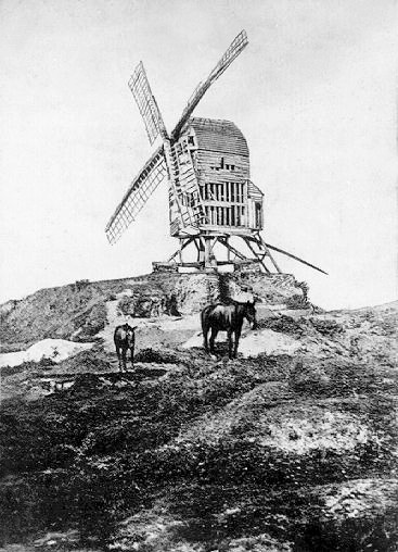
Fig. 14.6: Hawridge smock and
steam mill
In the words of Stanley Freese, a “fine-looking though not well
designed smock mill” (fig. 14.6) was erected on Hawridge Common by
the ‘Norwich Wind and Steam Mill Company’ in 1863, and came complete
with steam engine to supplement the wind; old photographs depict an
impressive brick chimney and, by 1866, a delivery note for half a
sack of flour (at 18s.0d.) was headed “Hawridge Wind and Steam
Mill”. The chimney was pulled down in 1884.
Hawridge smock mill was
unusual in Buckinghamshire in having a square two storey brick base, above which
was a narrow wooden tower whose walls were tarred. The four white
sweeps were of the patent anti-clock double-shuttered type, and the
fantail was six-vaned.
There is no continuous and completely reliable record of the various
millers and owners of Hawridge. The Millers who can be traced through
the census returns are . . . .
|
1861 |
Thomas Moreton, miller, born Nuneaton
Charles Pedel, journeyman miller, born Wendover |
|
1871 |
Joseph
Salt, miller, born Congleton
George Salt, miller, born Warwickshire
George Wright, miller, born Cholesbury |
|
1877 |
William
Wright, miller |
|
1881 |
Harry Wright,
miller, born Tring |
Original documents show that the mill was acquired in 1871 by
Humphrey Dwight, described as a pheasant breeder from Wigginton, who
purchased it from a consortium at Great Windsor. He paid £700, which
included “a messuage, granary and premises”, the legal aspects of
the sale being handled by Smith, Fawdon & Low of Chesham and Shugar,
Vaisey & Co. of Tring.
It seems that Dwight did not prosper, for ten years later the
freehold again changed hands. Dwight (described in the 1881 Census
as a farmer of 140 acres employing 5 labourers, and resident at 24 Bellingdon Road, Chesham) called again on the services of Tring
solicitor, Arthur Vaisey, who prepared on his behalf the following
statement dated 14th February 1881 . . . .
“I the undersigned Humphrey Dwight of Bellingdon near Tring having
been served with a Writ for the sum of £578.5s.2d. due from me for
principal and interest to the executors of the late Mr John Merritt
Shugar which sum is charged upon my freehold mill and premises
situate at Hawridge Bucks hereby authorise and request you to take
the necessary steps on my behalf for selling the said mill and
premises either by public auction or private contract and also to
endeavour to get any further proceedings on the said Writ stayed
pending the sale of the property.”
On 26th February, William Brown & Co. received instructions to
auction the mill, the sale being held at the Rose and Crown Inn,
Tring. The auctioneers described the property as a . . . .
“Free hold Windmill with steam power attached, driving four pairs of
stones, situate on Cholesbury Common, part in the Parish of
Cholesbury, part in the Parish of Hawridge; also capital residence
with garden, yard, and stabling. The property is in the occupation
of Mr Wright, a yearly tenant at a rent of £400 p.a.”
The sale realised exactly £600, which Humphrey Dwight was obliged to
surrender to settle the debt together with a further £20. 18s. 5d. to
cover auctioneer’s and solicitor’s fees.
The mill is believed to have been bought by Daniel, another member of the
extensive Dwight dynasty, who at some time between 1881 and
1883 replaced the smock mill with the tower mill (Chapter
IX) that stands
today. The reasons for demolishing a mill only twenty years old were
given as inconvenient arrangement; poor construction; loading floor
on the ground instead of at cart-level; and no bin floor, resulting
in grain having to be fed directly into the eye of the millstones
instead of being shot down from storage bins in the floor above. These defects probably rendered the mill unprofitable to work, and
might in turn explain the frequent change of millers. But one miller
is known to have given up the mill for an unrelated reason. Joseph
Salt met a tragic death when, helping to right a derailed locomotive
in the neighbouring Tring valley, he failed to let go of a lever
when it was released by the other workmen, and was killed as a
result.
During its demolition, the smock mill’s machinery and other parts
were salvaged to be incorporated in the new tower mill. Today, a
fitting reminder of Hawridge’s old smock mill lives on in the shape
of the logo of the Hawridge & Cholesbury Cricket Club, whose members
are fortunate enough to have a pitch on the beautiful Common.
MARSWORTH
The Domesday survey records three mills in the Manor of Marsworth. By 1292 a water mill existed, valued at £4. 9s. 4d., which descended
through various owners, eventually becoming known locally as Dyer’s
Mill. It stood in the south-west corner of the village, and
according to the Victoria County History (Vol.3), it was “turned
into a windmill”, which seems quite possible since the construction
of the Grand Junction Canal diverted the water, thereby
incapacitating all Marsworth’s watermills.
A reference of 1817 records that a Thomas Sear insured a brick and
timber wind-driven corn mill with no kiln and two pairs of stones
for £600 and an adjoining house for £200, the whole a quarter of a
mile west-south-west of Marsworth church. In 1824, members of the
Sear family leased the premises to William Pickett, shopkeeper of Marsworth. These included “a recently erected windmill on the same
site of the former watermill”.
Twenty years later Thomas Sear sold the mill to a horse dealer,
Charles Gregory, who took over the £400 mortgage. After a few years
it was sold on again to Thomas Clarke, miller of Tring, who in his
turn took over the mortgage and insurance payments, also obtaining a
second mortgage of £1,000 to erect a steam mill “adjoining to the
said Wind Corn Mill”. The Indenture included a requirement to keep
“the wind corn mill insured against loss or damage by fire, and to
run the business correctly”. By 1875 the mortgage was paid off.
Thomas Clarke died intestate, and his property was offered for sale
at the Rose & Crown, Tring; Thomas Mead, a local miller, bought the
entire premises for £1,500. According to the sale advertisement that
appeared in the Bucks Advertiser during January, 1881, it comprised
. . . .
“. . . . a Steam Mill of 5 floors fitted with a 12 hp. Steam Engine,
a 16 hp boiler, 3 pairs of stones with elevators, and all necessary
shafting and gearing, most completely fitted, and all in perfect
order; a SIDE MILL of 4 floors, communicating therewith from each
floor; a bean and drying kiln; a comfortable dwelling house, adapted
for the proprietor with all necessary fittings; a stable for 4
horses, with loft over; various convenient out-houses; good garden;
close of pasture and orchard land, together about one acre, one
rood, and one pole, upon which a lucrative business has for 28 years
past been carried out . . . .”
Thomas Mead already owned a new steam-driven mill at Gamnel Wharf,
Tring, and bought Marsworth windmill possibly as a strategic
purchase to prevent any competition with this new venture. However,
he had no use for the old windmill which was eventually demolished
c.1919.
Elderly residents of Marsworth, when interviewed during the 1930s,
recalled that the windmill’s sails were torn off in a gale in about
1845 and the gear so damaged that for a considerable time the mill
was unworkable. A man who assisted with the demolition remembered it
being built of red brick, four storeys high but without a stage, and
with four patent sweeps and the usual fantail.
OTHER VANISHED WINDMILLS
|
 |
|
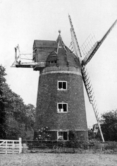
Fig. 14.7:
Parson’s Mill, Brill |
In his book Hertfordshire Windmills and Windmillers, Cyril Moore
refers to several windmills in the broad locality of Tring about which
very little is known. That at Abbots Langley, believed to have been in
the vicinity of Catsdell Bottom, was standing in 1912 in a derelict
condition. There is evidence of two windmills at Berkhamsted, one of
which, a post mill, is depicted in an 18th century view of the town
that places it in the vicinity of Millfield Road. The windmill at
Little Gaddesden probably disappeared in antiquity, with old
references to a “Mill Field” to the south-east of the church being
its last trace.
To the north of Tring, there were windmills at, among other places,
Brill and Quainton — in addition to those that remain at both
locations — and at Wing, Wingrave and Waddesdon.
At Brill, the famous post mill that stands on the Common once had a
near neighbour. Built in 1634 and latterly known as Parson’s
Mill, it stood on the opposite side of the road. Unlike its
neighbouring post mill, Parson’s Mill did not have a roundhouse, but
at the time of its demise and on the grounds of comparable age, the two mills were probably similar in other respects. Struck by lightening in 1905, the mill
was demolished in the following year; the mound (‘tump’) on which it
stood (seen in the photograph) remains visible.
|
 |
|
Fig. 14.8:
Waddesdon mill stood on Windmill Hill |
There is no record of when Waddesdon Mill was built, although it was
standing in 1834, for in Cook’s History of the English Turf the
author describes a steeplechase run in that year over a course from Waddesdon windmill to Aylesbury Church, while from a slightly
earlier period the account book of the Aylesbury millwright William
Cooper (Chapter V) records that he undertook work on a windmill at “Wadsdon”;
it is also believed that John Hillsdon of Tring was in some way
connected with the mill. [6] The mill is said to have been a particular favourite of Miss Alice
de Rothschild, who had inherited the great Waddesdon estate from her
brother, Baron Ferdinand. In its latter day this attractive
tile-hung windmill was said to be more ornamental than practical,
for local rumour has it that if the wind was favourable it was set
to work for no better purpose than to greet Miss Alice on her return
to the village after her absences abroad, and she is believed to
have paid for its restoration in the early years of the 20th century
(c. 1905). English Windmills (Vol. 2) records that (c.1930) the mill
was “slowly decaying”; according to Stanley Freese, it met its fate
when “it was dynamited by the Baron’s nephew for no apparent reason
in the summer of 1932”.
The history of the fine tower mill that stands near the village green
at Quainton is
well known; much less is known about the village’s other
windmills, of which there were several over the centuries although
only scant references to the earliest of them exist.
The first windmill about which there is firm information
stood at Blackgrove Farm to the south-west of Quainton village.
Owned by Thomas Anstiss,
who later erected Quainton tower mill (Chapter
XI), ‘Banner Hill Windmill’ opened for business on the 16th May
1797, having been erected in the short space of 57 days. Following
completion of the tower mill, Anstiss sold Banner Mill, which was
later dismantled and moved to Mursley (c.1840) where it continued in operation
until the 1890s, when it burned down in mysterious circumstances.
Another post mill, ‘Curtis’s Mill’, named after its owner Thomas
Curtis,
stood at Quainton on Seech Field near to the railway station.
Built towards the end of the 18th century, she was an open-trestle post mill with four cloth sails,
which drove two pairs of stones (4ft 4ins and 3ft 10 ins) and a
dressing machine. According to the windmill researcher Stanley Freese, “She was a nice
little fast-running mill, she would always go, even when the giant tower
mill refused to start”.
“QUAINTON. — On Wednesday morning last the
old mill belonging to Mr. Thomas Curtis at Quainton, was discovered
to have been broken open, and about four bushells and a half of
flour, with two sacks, stolen therefrom, the property of Mr. W.
Cooper, baker, of Quainton. Information having been given to Mr.
Read, the constable, he was soon on the spot, and found footmarks
near the mill which he traced over the new inclosed fields and quick
sets in a direction for Waddesdon, nearly up to some houses occupied
by Jos. Kibble and F. Cripps, and with the assistance of Mr. Paine,
another constable, made a search of the above houses and succeeded
in finding about the quantity of flour lost lost, when Kibble and
Cripps were apprehended, and taken before the Rev. E. N. Young the
next day, who after hearing the dispositions of the witnesses,
committed then to Aylesbury goal to take their trial for the offence
at the next Quarter Sessions. Mr. Cooper and other witnesses were
severally bound over to appear against them. This mill was broken
open in February last, on which occasions a quantity of meal was
stolen therefrom.”
Bucks Herald,
19th April 1845
The mill was sold at least twice
during her life; in 1854, she was put up for auction together,
with a granary for 100 sacks of flour and stables. Whether she
sold or not is unknown, for the following year a newspaper article
describes an . . . .
“. . . .
excellent supper at the George Inn given by Messrs
Hillsden,
Millwrights of Tring, on closing the works of a new mill belonging
to Messrs Curtis of Fulbrook, on the site of the old mill which
stood for a number of years in Seech Field. Mr Huckvale, the
tenant, presided.”
Bucks Herald,
10th November 1855
One assumes from this that the “old mill” was in a poor state
of repair and was substantially rebuilt, for the “new mill”
was unlikely to have been of the post mill type. In 1870,
Curtis’s Mill was put up for auction, on this occasion as part of a
larger lot:
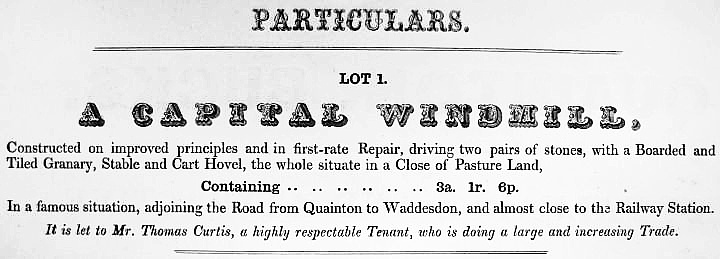
Fig. 14.9: The auctioneer’s
particulars for sale held on the 9th June, 1870,
at the White Lion
Inn, Quainton
In February 1892, the Mill was again put up for Auction — according
to the advertisement, Thomas Curtis remained the “proprietor”)
— and in September 1897 it was advertised to let. Over a
century of milling on the site came to a close at some time around
1900, and in 1912 the mill was blown down in a gale.
Wing’s windmill is marked on the 1770 and 1788 Thomas Jeffery maps
of Buckinghamshire situated on the northern side of Aylesbury Road.
The windmill had ceased operations by 1798 when it was noted as “due
to be taken down immediately” in the Posse Comitatus of that year.
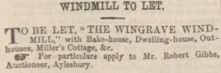
Fig. 14.10: Bucks Herald,
4th July 1863
The smock mill at Wingrave stood at Windmill Farm. It had been moved
from Whitchurch in 1809 and operated at Wingrave until about 1872,
when it was replaced by a steam mill elsewhere in the village. In
December, 1841, the Aylesbury News announced that . . . .
“Wingrave Windmill — the above mill having undergone extensive
repairs and improvements W. Burton begs to inform his friends that
he will work day and night (wind permitting) to fetch up his arrears
of grinding”.
The windmill’s sails evidently came very near to the ground, for it
is recorded that they once killed a passing pig.
At Wendover, a windmill is marked on maps by Jefferys (1768) and by
Andrews and Dury (1809) standing upon the high ground adjoining
Hale Road and almost opposite the east end of Chapel Lane, about a
quarter of a mile north-east of the Parish Church. The name of the
field where the mill stood is Snail Hill, but nothing else is known
about it.
These are just a few of the windmills that once graced our locality
and that gradually fell into disuse and decay as industrialisation
progressed and our way of life changed. An article in the Home
Counties Magazine (Vol. II., 1900) gives a contemporary view of
these romantic, but sadly vanishing landmarks . . . .
“With the increasing application of steam to milling purposes, and
the improved means of transport of foreign flour, it is pretty clear
that the days of windmills, if not quite over, are rapidly becoming
fewer, and at no very distant date most of the numerous picturesque
examples now left in the Home Counties will have fallen victims to
neglect and decay, or have been swept away to make room for more
utilitarian buildings. . . . the old windmill on Mitcham Common is
likely to disappear before long. For so many years it has been one
of the chief landmarks of the Mitcham district, and especially of
the heath upon which it stands, that its removal can hardly fail to
produce that feeling of regret which is inseparable from the
destruction of old and familiar features in a landscape.”
Where a windmill has left any trace at all, it is often in nothing
more than a name, the significance of which has long been forgotten.
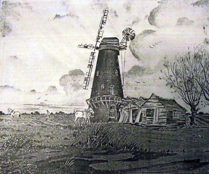
Fig. 14.11: Croxley Green
windmill
Croxley Green Windmill was built c.1860. The mill was working
by wind until its sails were blown off during the 1880s, and from
1886 it was worked by steam engine only. The mill was last
used to grind wheat in 1899. The mill was equipped with four
patent sails that drove three pairs of stones. |